RAH disco seems bullish on today
-
Hello, please take a minute to check out our awesome content, contributed by the wonderful members of our community. We hope you'll add your own thoughts and opinions by making a free account!
You are using an out of date browser. It may not display this or other websites correctly.
You should upgrade or use an alternative browser.
You should upgrade or use an alternative browser.
Arctic April
- Thread starter NBAcentel
- Start date
Jessy89
Member
Sunday Monday could be a flooding issue 3-5 inches rain gfs and Canadian models in some areas
Sent from my iPhone using Tapatalk
Sent from my iPhone using Tapatalk
B
Brick Tamland
Guest
RAH disco seems bullish on today
NEAR TERM /THROUGH TONIGHT/...
As of 1115 AM Wednesday...
Minimal changes to the forecast. The outflow boundary from the late-
night/early-morning MCS over S OH/WV/VA has propagated southward
into NC, reaching the W Piedmont, N Sandhills, and the central
Coastal Plain. We`re still eyeing this boundary as a likely focus
for convection this afternoon, with strong heating and subsequent
destabilization eventually busting through a prominent cap noted on
the 12z GSO sounding at around 800 mb. Once that occurs, strong
updrafts are likely with fairly steep lapse rates through the EML
depth, particularly 750-500 mb. MLCAPE is expected to reach 1000-
1500 J/kg within 30-40 kt of deep layer shear this afternoon,
supportive of vigorous rotating updrafts with the potential for
splitting cells. Large hail appears to be the primary threat, with
damaging wind gusts a close second. -GIH
Yep didn't expect them to be that bullish. Big hail potential day to be honest. Looking at the visible satellite the outflow has gone to our south but tails back from asheboro toward boone. If that stays in there today storms would likely form on that arc then move ESE into our area
NBAcentel
Member
Hrrr looks to be Lessening coverage each run, almost looks like downsloping kills off storms, hopefully this is not the case as I’m looking forward to today
BHS1975
Member
Hrrr looks to be Lessening coverage each run, almost looks like downsloping kills off storms, hopefully this is not the case as I’m looking forward to today
Yeah looks like Monday’s coverage.
Sent from my iPhone using Tapatalk
Webberweather53
Meteorologist
No.

Dawgdaze22
Member
Lol
Sent from my iPhone using Tapatalk
accu35
Member

Good News!
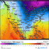
Weather.us now has ERA5 Reanalysis data going back to 1979.
Here is an example from the blizzard of 93. I bet this is going to be extremely useful in the storms to come.

 weather.us


Weather.us now has ERA5 Reanalysis data going back to 1979.
Here is an example from the blizzard of 93. I bet this is going to be extremely useful in the storms to come.
ECMWF ERA5 (Reanalysis) | USA
Historical weather maps, USA - Temperature (°F) | ECMWF ERA5 (Reanalysis)
Attachments
Last edited:
I don't understand why snow is a bad thing now. It's not like we have to go somewhere.
Webberweather53
Meteorologist
I don't understand why snow is a bad thing now. It's not like we have to go somewhere.
Lol been beyond ready for spring now, winter should have tried a little harder when it actually mattered in January. This is sort of like a basketball team being down 60 points with 3 minutes left in the 4th quarter and your star player finally starts draining 3s. It's annoying lol
accu35
Member
BRING THE SNOW!!
NBAcentel
Member
Welcome to April 


LickWx
Member
Its the growing season now farmer got their soil tilled and crops that are harvested in early summer are growing..... it would not be good for anybody.I don't understand why snow is a bad thing now. It's not like we have to go somewhere.
Jessy89
Member
I wouldn’t care if it snowed 6 inches from Atlanta to most the Carolinas in may. It give relief from heat
Sent from my iPhone using Tapatalk
Sent from my iPhone using Tapatalk
Its the growing season now farmer got their soil tilled and crops that are harvested in early summer are growing..... it would not be good for anybody.
Taking what you’re saying a step further, neither would severe wx be good for anyone at any time (actually the effects are potentially way worse obviously) but that doesn’t stop some folks for rooting for it. So, as far as this forum is concerned, what you’re saying is pretty much irrelevant.
Snow would be fine if it's above freezing. A freeze at this point in our region is an ag nightmareIts the growing season now farmer got their soil tilled and crops that are harvested in early summer are growing..... it would not be good for anybody.
NBAcentel
Member
Snow would be fine if it's above freezing. A freeze at this point in our region is an ag nightmare
Yeah definitely, would be really bad to get a freeze right now
NBAcentel
Member
Hrrr upping coverage again 

Tornado warnings dropping out of Kentucky. I agree with no watch for NC it should dry up once in southern Virginia.
Avalanche
Member
Really need those storms to survive the App downslope. Parts of central NC are dry.
This post tooReally, my gifs had to be deleted from this thread?
NBAcentel
Member
Still looks like this MCS May make it and actually redevelop past the mountains given MUcape values up to 1500jkg, shelf clouds will be nice as heck if this holds, especially right at sunrise 
Is it too arduous to get a decent thunderstorm right now? I want some big boomers, wind, very heavy rain, and maybe some hail. Just your good ole fashioned southern spring storm. Boy, would that help my anxiety and stress right now!
NBAcentel
Member


NBAcentel
Member
it’s worth noting that the main threat with that MCS would be large hail given that soundings are elevated in nature with steep mid level lapse rates, 1000-2000 jkg of MUcape and solid 0-6km bulk shear, although some areas could see strong wind gusts, especially in the mountains 
BufordWX
Member
Severe thunderstorm watch issued for parts of Mississippi and Alabama until 9:00 PM CDT.
This is the first year I've had all my apples bloom in full and all together. We are set for two frosts in the next week but hopefully it doesn't get too cold.Snow would be fine if it's above freezing. A freeze at this point in our region is an ag nightmare
FCX radar is lighting up. Should get a line of storms into central nc by 7-9pm
NBAcentel
Member
FCX radar is lighting up. Should get a line of storms into central nc by 7-9pm
Yeah the hrrr has come back to life, lol, shows more storms again, been noticing to my north what looks almost like a boundary where I’ve seen towering cumulus continue to fail but they won’t stop building, and its this general area to my north

BufordWX
Member
Hrrr continues to advertise some pretty good storms coming through Tennessee tonight. Loads of Cape for them to work with too.
BufordWX
Member
Meanwhile in Illinois, anyone up for some Softball sized hail?
Dawgdaze22
Member
Meanwhile in Illinois, anyone up for some Softball sized hail?View attachment 38695
Is this the same system for in the morning?
Sent from my iPhone using Tapatalk
BufordWX
Member
It’s the beginning phases of it forming right now. I doubt we will see softball sized hail anywhere down here.Is this the same system for in the morning?
Sent from my iPhone using Tapatalk
Webberweather53
Meteorologist
These storms just bulldozed their way through the mountains... Here we go.
Brent
Member
Record high while talking about an Arctic front lmao

Webberweather53
Meteorologist
This storm outside of Roanoke, VA looks nasty. Definitely could see wind gusts of up to 70+ mph downstream in N.C. once the trailing stratiform precipitation is able to establish a strong rear inflow jet, this usually just takes time.

That storm rolling into blacksburg is a beastThese storms just bulldozed their way through the mountains... Here we go.
Jessy89
Member
What would softball size hail sound like on a ten roof of a mobile home? Good sleeping weather?
Sent from my iPhone using Tapatalk
Sent from my iPhone using Tapatalk