Air you can wear luckily tomorrow hopefully will be the last oppressive day for a littleRemember when a certain poster quoted my posts a couple weeks ago about the heat
-
Hello, please take a minute to check out our awesome content, contributed by the wonderful members of our community. We hope you'll add your own thoughts and opinions by making a free account!
You are using an out of date browser. It may not display this or other websites correctly.
You should upgrade or use an alternative browser.
You should upgrade or use an alternative browser.
Pattern Ablazing August
- Thread starter SD
- Start date
NBAcentel
Member
Yes something for the OFB to kick up later ! 

Brent
Member
Heat index 109
So excited
So excited
NBAcentel
Member
NBAcentel
Member
Oh boy 

NBAcentel
Member
Update 
outflow just rolled thru and nada ???

Sent from my iPhone using Tapatalk

Sent from my iPhone using Tapatalk
smast16
Member
Why?? 
NBAcentel
Member
Haha Suckers 
NBAcentel
Member
These look like desert SW thunderstorms so high based 
NBAcentel
Member
These LCLs are high 
Anyone higher than RDUs 96 today?
Looks like 94 imby
Looks like 94 imby
Too bad this.png")
Isn't supported by this
.png")
Isn't supported by this
smast16
Member
Anyone higher than RDUs 96 today?
Looks like 94 imby
Caught it at 97, but was showing 98 before I could get a shot. My pws also reports 97 max.

Good thing the dog days of summer were over or we might have busted high...
Ohh wait.
NBAcentel
Member
Made it to 96 actually mixed out like the hrrr showed for once
JHS
Member
18z GFS is probably right. Less than .50 for much of SC through 192. Gonna have to wait for whatever comes behind Fred I guess.
LickWx
Member
Mid Atlantic and northeast are blazing , upper 90s across the region . That trickled down to here . Hit 98 today and i think tomorrow may be the hottest day yet so 100 may be possible lmao. Though prolly not , we will see . Maybe another 96-99 day .
How the last 3 weeks went :
1. cool down and lots of rain coming
2. Ok well look like it warms up after cool down , but prolly lots of 88s and 89s
3. Ok well looks like regular heat, some low 90s . Defo nothing higher .
4. Well ---- we been above 95 3 days straight now with heat index’s above 105 , peaking 107-108. Even nearing 100 for temps .
This heat is quite the surprise . Hottest day of the summer after dog days are over ? Someone fire up a thread !
Last edited:
NBAcentel
Member
Watch out that might make the weenies dislikeMid Atlantic and northeast are blazing , upper 90s across the region . That trickled down to here . Hit 98 today and i think tomorrow may be the hottest day yet so 100 may be possible lmao. Though prolly not , we will see . Maybe another 96-99 day .
How the last 3 weeks went :
1. cool down and lots of rain coming
2. Ok well look like it warms up after cool down , but prolly lots of 88s and 89s
3. Ok well looks like regular heat, some low 90s . Defo nothing higher .
4. Well ---- we been above 95 3 days straight now with heat index’s above 105 , peaking 107-108. Even nearing 100 for temps .
This heat is quite the surprise . Hottest day of the summer after dog days are over ? Someone fire up a thread !
LickWx
Member
Lol I had tagged Shane initially that’s why he disliked . I’m surprised myself , I mean initially models last week hinted at this but it was kind of disregarded , then it actually happened . Still nothing truly noteworthy though. Just the hottest of the summer.Watch out that might make the weenies dislike
NBAcentel
Member
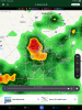
Hrrr says ? 
LickWx
Member
100 is possible tomorrow , I give it a 30% chance of happening. Prolly tops out at 99. Imma be out all day too . In the heat island of Raleigh roasting. Should be great .Hrrr says ? View attachment 88091
Told ya18z GFS is probably right. Less than .50 for much of SC through 192. Gonna have to wait for whatever comes behind Fred I guess.
cd2play
Member
SH*T!

Almost 11 pm and heat indexes still either side of 90, yuck
Brent
Member
Almost 11 pm and heat indexes still either side of 90, yuck
Ugh yeah I just went outside and it's still gross
smast16
Member
Watch out that might make the weenies dislike
They are suspiciously quiet right now. Slippin into the bushes like Homer....
SouthGarnerSleet
Member

75 for the low
BHS1975
Member
LickWx
Member
Low of 76 , temp up to 79 now . 2 degrees warmer than this time yesterday . 100 looking more possible , I’ll up the chance to 40%.
I'm at least interested in the possibility RDU hits 100 today hrrr has 850s around 21/22Low of 76 , temp up to 79 now . 2 degrees warmer than this time yesterday . 100 looking more possible , I’ll up the chance to 40%.
Burned crispyCrisp
Sent from my iPhone using Tapatalk
It's Ablazing out there.
86 for the 10am RDU ob. Need to be around 93-95 at noon to have a good shot at 100
Shaggy
Member
86/77 HI 97 at 1015am. Pits of hell!!
86
30°C
86
30°C
| Humidity | 75% |
| Wind Speed | SW 6 mph |
| Barometer | 30.16 in |
| Dewpoint | 77°F (25°C) |
| Visibility | 7.00 mi |
| Heat Index | 97°F (36°C) |
| Last update | 13 Aug 10:15 am EDT |
smast16
Member
So, I personally believe this thread was aptly named after all...
Damn its hot out there.
Damn its hot out there.
Look at all the heat advisories and excessive heat warnings.

Shaggy
Member
Triple digit HI before 11AM. Fun times
Last edited:
LickWx
Member
90/77 at RDU. 1 degree ahead on temp vs yesterday and 3 degrees higher on dew.Triple dogit HI before 11AM. Fun times