Shaggy
Member
Most models are calling for another inch or two around here, but I'm skeptical, looking at the radar. Upstream returns are fairly paltry.Models had done pretty good showing this rain minimum down along I95.
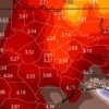
2.39 hereWow! You all are getting soaked, 7-8 inches. 2.8 is my total since Monday. Curious to hear some RDU totals.
We are definitely a bit soggy here.Wow! You all are getting soaked, 7-8 inches. 2.8 is my total since Monday. Curious to hear some RDU totals.
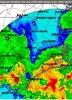
BIG moisture plume coming off the Atlantic will dump on areas of NC from Raleigh north and east. You can see a little meso low, on radar, spinning as it traverses NW. Also some lightning returns showing up.
I’ll tell you what the HRRR and HRRRX 12z really showing some good severe weather setting up tomorrow .. should be quite interesting


As usual the Euro was impressive...
Mondays 12z run compared to actual
View attachment 41820View attachment 41821