Z
-
Hello, please take a minute to check out our awesome content, contributed by the wonderful members of our community. We hope you'll add your own thoughts and opinions by making a free account!
You are using an out of date browser. It may not display this or other websites correctly.
You should upgrade or use an alternative browser.
You should upgrade or use an alternative browser.
Severe 4/4-4/6 Severe Threat
- Thread starter Snowfan
- Start date

Z
Zander98al
Guest
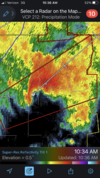
It's winding up whenever yo usee that big inflow stretching east through that supercell it's never a good sign. It's got some staying power.Mercy. That southern cell is about to drop a big tornado.
Probable TDS on that cell now.It's winding up whenever yo usee that big inflow stretching east through that supercell it's never a good sign. It's got some staying power.
Nasty hook on that thing…Probable TDS on that cell now.
Z
Zander98al
Guest
That south cell is still gaining strength
Z
Zander98al
Guest
Z
Zander98al
Guest
125+ mph inflow
Oh man. North of Montgomery 
Z
Zander98al
Guest
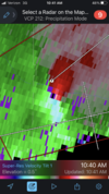
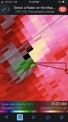
WOAH! Been focused on the furthest south cell and didn't notice that onwOh man. North of Montgomery View attachment 116788
CC drop. Tornado down. 
Z
Zander98al
Guest
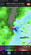
That's a very populated area, the city of wetumpkaCC drop. Tornado down. View attachment 116789
- Joined
- Jan 5, 2017
- Messages
- 3,794
- Reaction score
- 6,035
It does appear to be on the south side of town, which is mostly wooded and sparsely populated.That's a very populated area, the city of wetumpka
Z
Zander98al
Guest
TDS on southern most cell
Z
Zander98al
Guest
That's a very bad tornado deep CC.
Whats the latest for areas between Savannah and Charleston? Thanks!
lj0109
Member
Inflow increasing south of the weakening couplet on the southern cell. Probably about to see a cycle.
Yup. Maybe two tornadoes on the ground now.Inflow increasing south of the weakening couplet on the southern cell. Probably about to see a cycle.
Attachments
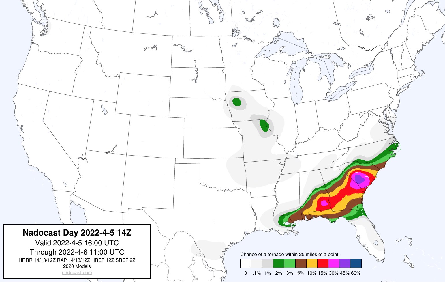
Why would that nadocast image be so extreme over SC but not showing very high % where they are actually occurring...
Just saying...
I really wish they would change something about that image.. it looks too official for the average person who sees it.
Just saying...
I really wish they would change something about that image.. it looks too official for the average person who sees it.
Maybe not. In any case, here comes round two.Yup. Maybe two tornadoes on the ground now.
Attachments
Z
Zander98al
Guest
Agree, it's performed very poorly even today, especially in past events.Why would that nadocast image be so extreme over SC but not showing very high % where they are actually occurring...
Just saying...
I really wish they would change something about that image.. it looks too official for the average person who sees it.
Z
Zander98al
Guest
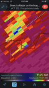
Think on
Think one is debris fall out and one is the actual tornadoYup. Maybe two tornadoes on the ground now.
Unwarned tornado just south of KMXX radar!
Z
Zander98al
Guest
Debris fall out from the tornado north of the radar site, very deep CC. even so close to radar.
Not gonna mince words, they dropped the ball on that on. On the ground for ten minutes before they warned it.Unwarned tornado just south of KMXX radar!
lj0109
Member
Agreed. Was just pointing it out in the FWIW department. I do think the 30-45% are outlined by its projection will likely be a prime spot this afternoon for activity if these discrete cells get going, but it is likely too extreme with its percentages.Why would that nadocast image be so extreme over SC but not showing very high % where they are actually occurring...
Just saying...
I really wish they would change something about that image.. it looks too official for the average person who sees it.
The 10z forecast was higher in the area that's getting the warnings now. It's probably overreacting some across sc due to the crazy high shear and the increasing sfc based instability across scWhy would that nadocast image be so extreme over SC but not showing very high % where they are actually occurring...
Just saying...
I really wish they would change something about that image.. it looks too official for the average person who sees it.
I've posted this guy before but he does a good live stream of all current severe, and streams chasers too
Yeah what's hitting you is eventually hitting me. I thought it was suppose to hit at 2 - 3 pm. Not noon.On a side note it has been flooding here for about 3 and half hours with no end in sight
Since 1986, 2022 to-date is already well ahead every other year for Tornado Warning count in FWD's CWA.

Seems like the area with the highest chance of getting a significant tornado may be on the southern edge of the current rain shield from Macon to Augusta to Columbia, Florence and maybe Wilmington
Chiliphil1
Member
I’ve been slightly confused with it. It was supposed to roll in early afternoon but it’s been raining since 9-10.Yeah what's hitting you is eventually hitting me. I thought it was suppose to hit at 2 - 3 pm. Not noon.
Chiliphil1
Member
No current tor warnings, last one just expired.