Mesoscale Discussion 0398
NWS Storm Prediction Center Norman OK
0625 PM CDT Mon Apr 04 2022
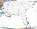
Areas affected...Central/North-Central Texas and extreme
South-Central Oklahoma
Concerning...Severe potential...Tornado Watch likely
Valid 042325Z - 050100Z
Probability of Watch Issuance...80 percent
SUMMARY...Tornado watch will likely be issued by 0030-0100z for
portions of Central/North-Central Texas.
DISCUSSION...Moist boundary-layer surge, characterized by mid 60s
surface dew points, is advancing north across central TX and will
soon spread into the Metroplex. Latest satellite and radar imagery
support this with scattered showers now evident just east of Waco
into Ellis County. Given the approaching short wave there is
increasing concern that scattered supercells will evolve within this
more buoyant, and strongly sheared environment. Current thinking is
the warm frontal position may not advance appreciably north from its
current position and given the amount of convection observed over
southern OK this seems reasonable. As LLJ strengthens into the
Arklatex this evening there is increasing concern for the potential
for tornadoes. Tornado watch will likely be warranted by 01z across
this region.
..Darrow/Thompson.. 04/04/2022
...Please see
www.spc.noaa.gov for graphic product...
ATTN...WFO...SHV...FWD...OUN...
LAT...LON 31649784 34009674 33749523 31419622 31649784