lexxnchloe
Member
I am glad someone gets it, because for the life of me I sure don't.Not really but it’s a fantasy hurricane near your house so you’re pumped. I get it.
Please stop!!!! This is getting ridiculous
Ive been telling that to the ATL for a month nowPlease stop!!!! This is getting ridiculous
Glad it's fantasy....cause it leaves it hanging.....this one is just for fun.Meanwhile in the whacky season at 252 the cane is here
View attachment 150774
348 its here
View attachment 150777

Probably gone again in 6 hours, lol. 2 places to watch are the west GOM and the Carolina stormGlad it's fantasy....cause it leaves it hanging.....this one is just for fun.
View attachment 150781
I think what was meant is giving credence to individual deterministic model runs. Show the ensembles far out and then once there is really something to talk about then discuss the individuals. Just a guess though!Ive been telling that to the ATL for a month now
Just 2 weak lows on the EURO.
Yes and there is a 90L invest thread about it.The area being highlighted by the NHC around the Yucatán, is that what most models are picking up on moving a storm toward the northern gulf coast? Seems like the GFS on the 06Z has an area of low pressure in the gulf that then dives south. Just seems a little odd to me.

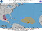
91L Thread60%
. Southwestern Gulf of Mexico:
A tropical wave over the Bay of Campeche is producing disorganized
showers and thunderstorms. An area of low pressure is forecast to
develop while the wave interacts with a frontal boundary during
the next couple of days. Environmental conditions are forecast to
be conducive for development, and a tropical depression could form
during the early or middle part of next week while the system moves
slowly northwestward to northward over the southwestern Gulf of
Mexico.
* Formation chance through 48 hours...medium...40 percent.
* Formation chance through 7 days...medium...60 percent.
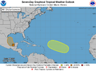
View attachment 150800

14 days out and hasn’t formed! Lock it in!It turns NNE and appears to be a safe recurve
View attachment 150820
Then turns NNW
View attachment 150821
View attachment 150822

