• Hello, please take a minute to check out our awesome content, contributed by the wonderful members of our community. We hope you'll add your own thoughts and opinions by making a free account!

Severe 2023 Spring Severe

Status
Not open for further replies.
Tomorrow could have several rounds of storms with all storm modes possible....low top supercells seem likely....any discrete ones will probably spin up.


Decent setup along and east of 95 the US1 to 95 corridor is a little more conditional tomorrow. Either way the ceiling is high but it'll be easy to get nothing
 
Decent setup along and east of 95 the US1 to 95 corridor is a little more conditional tomorrow. Either way the ceiling is high but it'll be easy to get nothing

Always the case...if it stays cloudy and cooler all day it will be a lot of meh
 
Hrrr looks good for tomorrow afternoon IMBY
 

Attachments

  • Screenshot_20230429_212151_Chrome.jpg
    Screenshot_20230429_212151_Chrome.jpg
    301.9 KB · Views: 12
day2otlk_0600.gif
 
Hi res runs are mainly a extreme NE NC severe setup....

View attachment 135139

View attachment 135140
On the large scale this is one of the setups in this area that can really produce this time of year. Backdoor front moving into a seasonally hot airmass with some glancing jet help can really fire up some decent wind/hailers. The big detractor becomes if the flow veers WNW or NW and we start mixing out or advecting in a lot of dry air which may be the case tomorrow. Additionally we may have a little subsidence in the wake of the weak mcv that rolls through early tomorrow to suppress things even more. Hires models probably have it right with the best chance of a severe storm being tied closer to the lift and along any moisture pooling ahead of the BD front. Will be interesting to see where we are around noon tomorrow
 
On the large scale this is one of the setups in this area that can really produce this time of year. Backdoor front moving into a seasonally hot airmass with some glancing jet help can really fire up some decent wind/hailers. The big detractor becomes if the flow veers WNW or NW and we start mixing out or advecting in a lot of dry air which may be the case tomorrow. Additionally we may have a little subsidence in the wake of the weak mcv that rolls through early tomorrow to suppress things even more. Hires models probably have it right with the best chance of a severe storm being tied closer to the lift and along any moisture pooling ahead of the BD front. Will be interesting to see where we are around noon tomorrow
Keep us posted on your thoughts!!!
 
If the last couple runs of the NAM are to be believed we might get in on some MCS action here in SE NC this evening. Looks to be in the 7pm-9pm range for my town in particular. Other mesoscale models are a little less enthusiastic but show some spotty storms. Been really tame this Spring in my neck of the woods maybe the NAM has the right idea. I'm ready for something with a little more teeth (as long as it doesn't cause major damage)
 
Last edited:
Yeah hrrr doesn't look overly excited ekther
The Hhhrrrrr was showing run after run storms for Sunday, while the 3k was showing zilch. Now, it's the opposite. I'm usually inclined to discount the HhrrrrRR any chance I get. That said, there just doesn't look to be a favorable setup for widespread coverage.

Scattered showers/storms with maybe a severe cluster somewhere in the east seems reasonable. 30% --> 50% central to east looks right to me.
The hrrr did really good a couple weeks ago and was really close to what happened.
 
12z NAM 3K coming in quite a bit weaker overall. NE NC still looks to at least get something but it is borderline nothing burger for SE NC. Looks like their *could* be a couple of small cells. Lame.
 
WRAL 's Mike Maze posted this on Facebook.

WRAL WEATHER ALERT DAY: We are starting to see showers pop up on the DD5K which could be the start of the storms for this afternoon. Still waiting for a Severe Thunderstorm Watch to be issued. It's watch and wait mode!
 
Not an exact match but initiation looks more like what the HRRR and most other mesoscales were showing and less like the NAM. Doubting the MCS playing out.

Yeah not seeing the big cluster forming in VA just yet.....needs to get popping soon if its going to keep the timing the hi res had....
 
Going to have to see how it plays out, pretty nasty cell moving into Pitt Co, worse looks to miss me west though....
 
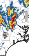
Severe Thunderstorm Warning for...
Northeastern Greene County in eastern North Carolina...
Central Pitt County in eastern North Carolina...

* Until 430 PM EDT.

* At 341 PM EDT, a severe thunderstorm was located 9 miles southeast
of Elm City, or 11 miles northwest of Farmville, moving east at 30
mph.

HAZARD...60 mph wind gusts and quarter size hail.

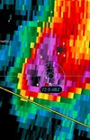
SOURCE...Radar indicated.

IMPACT...Hail damage to vehicles is expected. Expect wind damage
to roofs, siding, and trees.

* Locations impacted include...
Greenville, Winterville, Farmville, Bell Arthur, House, Bruce, East
Carolina University, Pitt Greenville Airport, Dowdy Ficklen
Stadium, Fountain, Simpson, Walstonburg and Falkland.
 
The hail we got was mostly dime with a few pennies. Bet it was way bigger than that a mile or two to my south. Damage report at Ballard's crossroads and a house fire that's about 2 miles to my southwest

 
Status
Not open for further replies.
Back
Top