-
Hello, please take a minute to check out our awesome content, contributed by the wonderful members of our community. We hope you'll add your own thoughts and opinions by making a free account!
You are using an out of date browser. It may not display this or other websites correctly.
You should upgrade or use an alternative browser.
You should upgrade or use an alternative browser.
Severe 2023 Spring Severe
- Thread starter SD
- Start date
- Status
- Not open for further replies.
BufordWX
Member
Gonna have to watch late week again for another severe threat. Already outlooks for Thursday and Friday. Probably will also have a small risk deeper into parts of the southeast on Saturday as well based on the current models.

NWMSGuy
Member
BufordWX
Member
Very large 30% region for Fridays severe threat.
tennessee storm
Member
It needs its own topic started ….threat end of this week
BufordWX
Member
Models starting to hone in another severe weather threat for next week. Very large surge of unstable air moves into the country by Monday.

tennessee storm
Member
This threat has a rather high ceilingModels starting to hone in another severe weather threat for next week. Very large surge of unstable air moves into the country by Monday.View attachment 134616View attachment 134615
Day 7...

Day 6...

As the western trough ejects on Day 6/Tuesday, potential significant
severe thunderstorms will be possible far eastern OK toward
southeast MO and vicinity. Rich boundary-layer moisture will be in
place amid steep midlevel lapse rates courtesy of an EML advecting
across the region from the Mexican Plateau. This will supply plenty
of instability with stronger vertical shear accompanying the
ejecting trough. There is some uncertainty among medium range
guidance on the northern extent of better moisture return and hence
severe potential. This is mostly driven by differences in surface
low, dryline and warm front positions related to somewhat different
ejection of the upper trough. However, guidance is in very good
agreement with respect to the southern portion of the risk area.
Supercells capable of all severe hazards, some potentially
significant, will be possible.
very large day 4 area...

Downeastnc
Member
Downeastnc
Member
Downeastnc
Member
Hazardous Weather Outlook
National Weather Service Newport/Morehead City NC
320 PM EDT Wed Apr 19 2023
NCZ029-044-045-079-080-090>092-193-198-201930-
Martin-Pitt-Washington-Greene-Beaufort-Duplin-Lenoir-Jones-
Northern Craven-Inland Onslow-
320 PM EDT Wed Apr 19 2023
This Hazardous Weather Outlook is for eastern North Carolina.
.DAY ONE...This afternoon and tonight.
Hazardous weather is not expected at this time.
.DAYS TWO THROUGH SEVEN...Thursday through Tuesday.
There is a threat for strong to severe thunderstorms later Saturday
afternoon into early evening, especially for areas along and west of
Highway 17.
Downeastnc
Member

The level 2 risk for Saturday has expanded. Something to watch for sure.
Downeastnc
Member
Hmmmm

Downeastnc
Member
Monster

Kentucky
Downeastnc
Member
The fact it has a bwer that close to the radar
Downeastnc
Member
The fact it has a bwer that close to the radar
Does not get more tornadoey than this...
Downeastnc
Member
hoping this thing waits till the other side of Temple Tx to finish cycling....
Downeastnc
Member
Not bad given a marginal risk....

Cell west of Greensboro getting interesting
Downeastnc
Member
Cell west of Greensboro getting interesting
Yep big ole meso just like hi res had

It really is spot on
Shaggy
Member
New Hrrr brings several UH tracks overhead here in a couple hours as some storms blow throughIt really is spot on
It's a decent setup right now to get a supercell that splits and a dominant strong cell moves right but there's no evidence of that happening. It's just a bunch of meh bumping around and interfering
Downeastnc
Member
It's a decent setup right now to get a supercell that splits and a dominant strong cell moves right but there's no evidence of that happening. It's just a bunch of meh bumping around and interfering
story of my life lately with storms....the warned cell is moving my way but will fizzle most likely.
Idk man its stout and alonestory of my life lately with storms....the warned cell is moving my way but will fizzle most likely.
Downeastnc
Member
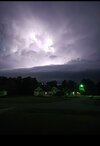
Heck of a light show at least

Shaggy
Member
Shaggy
Member
Shaggy
Member
Had a brief burst of pea sized hail.
Shaggy
Member
Sunday looks to have potential. Think we will see some watches up if the hi-res are correct. Also looks windy east of the low track regardless of storms.
Downeastnc
Member
I wont complain, had a insane lightshow for a over a hr, then some decent wind and 2 different hail cores though neither bigger than say a quarter with most being pea-nickel type stuff....nothing severe wind or hail wise. Still better than a lot of storms the last few years, which sadly means not many good storms.
Just had rain here again, like every weekend the past two months.
Shaggy
Member
Bumped up to slightly risk for Sunday for central and eastern NC. Generally east of US 1
Downeastnc
Member
Tomorrow could have several rounds of storms with all storm modes possible....low top supercells seem likely....any discrete ones will probably spin up.
- Status
- Not open for further replies.