Giddy up
-
Hello, please take a minute to check out our awesome content, contributed by the wonderful members of our community. We hope you'll add your own thoughts and opinions by making a free account!
You are using an out of date browser. It may not display this or other websites correctly.
You should upgrade or use an alternative browser.
You should upgrade or use an alternative browser.
Severe 2023 Spring Severe
- Thread starter SD
- Start date
- Status
- Not open for further replies.
Detective WX
Member
I mentioned in the Feb thread that we'll likely pay with a big severe wx outbreak this spring, especially if we transition into a Nino. 1932, 1957, 1974, 1998, 2008 and 2020 stick out with what we're currently going through.
BHS1975
Member
Friday looking good on the GFS.
Sent from my iPhone using Tapatalk
Sent from my iPhone using Tapatalk
NWMSGuy
Member
Looks like the GFS may be advertising a Severe Risk for someone in the South next week.
Ten days away, but gotta really watch that low amp wave on GFS and Euro.
Psalm 148:8
Member
- Joined
- Dec 25, 2016
- Messages
- 319
- Reaction score
- 701
So last night overnight fizzled in Alabama.. for which I’m thankful… but a thunderless, unwarned tornado hit southwest LaGrange in Troup County GA where I live last night.. ( see SPC’s) modified storm reports.. approximately 4:40 am EST. Anyone got fancy radar history on this?? Or what happened???? Very freakish event to say the least.. several businesses damaged… FFC has no mention on their website, but when I talked to them this morning, they were sending a team to investigate.
Best I can do as far as help.So last night overnight fizzled in Alabama.. for which I’m thankful… but a thunderless, unwarned tornado hit southwest LaGrange in Troup County GA where I live last night.. ( see SPC’s) modified storm reports.. approximately 4:40 am EST. Anyone got fancy radar history on this?? Or what happened???? Very freakish event to say the least.. several businesses damaged… FFC has no mention on their website, but when I talked to them this morning, they were sending a team to investigate.
Here’s the 4:28am and 4:40am radar images. I don’t have velocity. Looks like there was an individual cell down there that sort of separated from the line


Psalm 148:8
Member
- Joined
- Dec 25, 2016
- Messages
- 319
- Reaction score
- 701
Thanks for the assist!!! I was shocked… no thunder.. tornados from 2 separate system to wreck our county… done!!! Repeat DONE with severe season here in Troup County!
Drizzle Snizzle
Member
we still have March, April, and May to go through. Those seem to be the biggest severe weather months.Thanks for the assist!!! I was shocked… no thunder.. tornados from 2 separate system to wreck our county… done!!! Repeat DONE with severe season here in Troup County!
Darklordsuperstorm
Member
Heard lots of chatter from various sources on the weather community that I trust. The consensus seems to point towards an active season. Time will tell. In the mean time I will enjoy my 80 degree Temps this week ?
tennessee storm
Member
Gulf waters are getting primed already , warmer than average since hardly any cold has reached the region. So rich gulf flow moisture won’t be problemHeard lots of chatter from various sources on the weather community that I trust. The consensus seems to point towards an active season. Time will tell. In the mean time I will enjoy my 80 degree Temps this week ?
Darklordsuperstorm
Member
I don't think we're done seeing model runs like the Euro had this time last week for the most recent system. I wouldn't be totally shocked to see such runs verify this spring.Gulf waters are getting primed already , warmer than average since hardly any cold has reached the region. So rich gulf flow moisture won’t be problem
NWMSGuy
Member
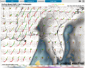
SPC is already highlighting a risk area centered around the Arklamiss for Wednesday of next week. 0Z EURO Flash Density during this time period provided below:


NWMSGuy
Member
Avalanche
Member
We need the rain!!
Euro continues to advertise a strong but broad wave now in the 8-9 day range. Definitely got to watch out for waves like that in the upcoming pattern.
Even the NWS said something about the same in The extended.
The presence of subtropical ridging will remain fairly steady-state
through the rest of the period. This will support above average
temperatures as a result, though temperatures will be more mitigated
by the presence of a front passing through the area Friday morning.
The effects of this meandering front and a couple passing
perturbations on the northern periphery of the ridge will lead to a
chance for rain each day, though I don`t have any thunder mentioning
at this time. A stronger signal for more organized thunderstorm
potential appears on Mon/Tue, outside the official forecast period.
40/Sizemore
BufordWX
Member
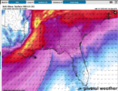
Looks like an early season severe threat may be shaping up across parts of the plains states for Sunday evening. Already a day 5 30% area for parts of TX/OK/KS.
Brent
Member
Looks like an early season severe threat may be shaping up across parts of the plains states for Sunday evening. Already a day 5 30% area for parts of TX/OK/KS.View attachment 133505
Yeah this is the first time I've seen some mets here mention the outbreak word this year
- Joined
- Jan 5, 2017
- Messages
- 3,608
- Reaction score
- 5,618
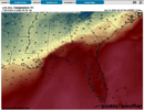
Both the Euro and GFS paint a nasty severe picture for AL/GA for the end of next week. Tornadoes look probable if that look continues to be depicted. We better hope the SE ridge stays put because when it slides out of the way, the transition going to full latitude trough is going to be harsh.
Attachments
accu35
Member
- Joined
- Jan 5, 2017
- Messages
- 8,717
- Reaction score
- 10,961
Scary look aheadBoth the Euro and GFS paint a nasty severe picture for AL/GA for the end of next week. Tornadoes look probable if that look continues to be depicted. We better hope the SE ridge stays put because when it slides out of the way, the transition going to full latitude trough is going to be harsh.
BufordWX
Member
Day 4 outlook for Sunday brought the 30% area east into OKC and Tulsa. 15% area expanded towards Dallas a well. Looks like this could be a pretty nasty wind event with a strong QLCS sweeping through.
- Joined
- Jan 5, 2017
- Messages
- 3,608
- Reaction score
- 5,618
Pulling for the Euro for next week. I really hope the GFS caves to it. GFS 70 kt bulk shear and 700 to 1700 J kg of CAPE would be rough as that squall line moves through, not to mention anything firing out in front of the line. Euro has a nice cold rain and elevated storms over my area, at least.
Attachments
NWMSGuy
Member
12Z GFS advertising a flooding rain situation for much of the Midsouth heading into late next week.
BufordWX
Member
Wind driven Moderate risk across western OK for tomorrow. So far temperatures look to only be in the low 60s tomorrow night so tornadoes shouldn’t be a significant problem, but there is a crazy amount of wind energy with this system. Tomorrow evening is gonna be interesting.
Brent
Member
Looks like a late night event here yay
Crazy to talk about considering it's still in the 40s here but that's probably why the tornado threat is muted
Crazy to talk about considering it's still in the 40s here but that's probably why the tornado threat is muted

Brent
Member
I dont think I've ever been in a moderate risk when it's 46 degrees .png")

BufordWX
Member
Strong wording on latest SPC outlook for today. Explicitly forecasting a derecho.
Darklordsuperstorm
Member
You don't see that type of wording often ?Strong wording on latest SPC outlook for today. Explicitly forecasting a derecho.View attachment 133641
Tornadocane
Member
Photograph of the Tornadic Cell in McClean, Texas. Nothing too impressive at the moment from the Tornado-warned cells in OK, KS, and TX. Highest Wind Speed recorded so far was 81MPH out of Haskell County, KS. https://www.spc.noaa.gov/climo/reports/today.html

Darklordsuperstorm
Member
Rare "Destructive" tagged severe thunderstorm warnings being issued. Confirmed wind gusts of 114 mph.
Darklordsuperstorm
Member

That type of wind is just insane!!
- Joined
- Jan 5, 2017
- Messages
- 3,608
- Reaction score
- 5,618
Tornado warning just north of Clemson, SC.
Oconeexman
Member
- Joined
- Jan 2, 2017
- Messages
- 1,247
- Reaction score
- 3,259
Yup it's very ominous looking outside suddenly..low clouds screaming north and high clouds not movingTornado warning just north of Clemson, SC.
Downeastnc
Member
- Status
- Not open for further replies.