• Hello, please take a minute to check out our awesome content, contributed by the wonderful members of our community. We hope you'll add your own thoughts and opinions by making a free account!

Tropical 2022 Atlantic Hurricane Season thread

In other news the GFS is trying to show something forming in the Caribbean from a storm in the EPAC that then threatens the east coast but again out in fantasy land. The Euro also shows something in the Gulf so maybe there's a little more support for something this timegfs_mslp_pcpn_watl_41 (1).pnggfs_mslp_pcpn_watl_44.png
 
GFS popped a home grown ( not one-e) in the Bahamas in the long range at 18Z that skirts the OBX as a TS at least....

gfs_mslp_pcpn_frzn_us_56.png
 
NHC starting to talk about it now on the Atlantic side

A broad area of low pressure is expected to form over the
southern part of the Bay of Campeche by the middle of next week.
Afterward, some gradual development is possible while the system
drifts generally eastward.
* Formation chance through 48 hours...low...near 0 percent.
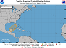
* Formation chance through 5 days...low...20 percent.two_atl_5d0 (1).png
 
A large and complex area of low pressure is expected to develop near
the Yucatan Peninsula and the northwestern Caribbean Sea in a couple
of days, partially related to the remnants of Tropical Storm Agatha
from the eastern Pacific. Despite strong upper-level winds over the
area, this system could become a tropical depression while it moves
northeastward over the northwestern Caribbean Sea and southeastern
Gulf of Mexico late this week. Regardless of development, locally
heavy rainfall is likely across portions of southeastern Mexico, the
Yucatan Peninsula, Guatemala, and Belize during the next few days,
spreading across western Cuba, southern Florida, and the Florida
Keys by the end of the week.
* Formation chance through 48 hours...low...near 0 percent.
* Formation chance through 5 days...medium...60 percent.two_atl_5d0 (3).png
 
Code Red

Near the Yucatan Peninsula and Southeastern Gulf of Mexico:
A large and complex area of low pressure is expected to develop near
the Yucatan Peninsula and the northwestern Caribbean Sea in a couple
of days, partially related to the remnants of Agatha from the
eastern Pacific. Despite strong upper-level winds over the area,
this system is likely to become a tropical depression while it
moves northeastward over the northwestern Caribbean Sea and
southeastern Gulf of Mexico late Thursday or Friday. Regardless of
development, locally heavy rainfall is likely across portions of
southeastern Mexico, the Yucatan Peninsula, Guatemala, and Belize
during the next couple of days, spreading across western Cuba,
southern Florida, and the Florida Keys on Friday and Saturday.
Interests in the Yucatan Peninsula, western Cuba, the Florida Keys
and the Florida Peninsula should monitor the progress of this
system.
* Formation chance through 48 hours...low...30 percent.
* Formation chance through 5 days...high...70 percent.
 
DeeeeTeeee seems alarmed!! Don’t know if that’s good or bad!?7927BC48-B396-4097-A36D-E1E00C60EDDC.png
 
Back
Top