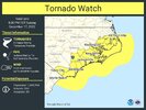
Wilmington write up
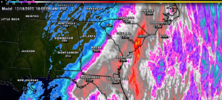
Not only does Sunday`s coastal storm start in the Gulf of Mexico
(usually a good indicator of a system that will be strong as it
turns up the East Coast)-but it forms south of both Texas and
Florida. Confidence is thus increasing that significant local
effects can be expected. Coastal flooding/beach erosion seem the
most likely as does strong winds especially along the immediate
coast.
The system will strengthen at a moderate pace as it moves across the
Gulf and Florida as it is only being driven by the southernmost mid
level jet and a weak (85kt) and zonal upper jet across the Gulf.
However as it turns to the NE a much stronger northern 500mb
trough starts to phase in, and the upper level jetting over FL
becomes increasingly cyclonic and accelerates to 100kt,
hastening the surface deepening. Given these factors feel some
guidance is playing catchup on the storm`s intensity save for
perhaps the EC which brings a 978mb low into the Cape Fear
Region Sunday night. Winds should peak ahead of the low`s
passage so highest gusts slated for midday Sunday (though an
overall slowing trend has been occurring in guidance). With last
Sunday`s system winds at 925mb were a good proxy for the wind
gusts that occurred with the overnight convection. Lapse rates
look much weaker with this system but the rain intensity may
overcome and mix winds down again from this height as it did
Sunday. If so then fairly widespread gusts of 40-50mph appear
possible with even higher gusts possible along the immediate
coast (the GFS has 60-65kt)...again some emphasis added to the
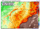
word `possible`. Some of these wind speeds are noted in many
`max wind swath` progs. A Wind Advisory does appear likely for
at least part of the area. Periods of moderate to heavy rain are
likely but with such dry antecedent conditions flooding should
stay confined to minor/nuisance.