• Hello, please take a minute to check out our awesome content, contributed by the wonderful members of our community. We hope you'll add your own thoughts and opinions by making a free account!

Pattern 12/15-19 Coastal!!!!!

The 0z NAM is northwest with the center, but much farther east with back of rain shield. There is little to nothing on the west or north side of the center as it moves up. Everything stays east and northeast of the center and the NW 3rd of GA and almost all of AL misses on this run. Under .50 west of Greenville in SC.
Any rain for the far southeast corner of AL around Dothan ?
 
The 0z NAM is northwest with the center, but much farther east with back of rain shield. There is little to nothing on the west or north side of the center as it moves up. Everything stays east and northeast of the center and the NW 3rd of GA and almost all of AL misses on this run. Under .50 west of Greenville in SC.
What’s the DGEX showing?
 
Almost 8” totals in Chas
With how dry it's been around this area, most areas could handle it, except the usual spots that flood when you spit on the sidewalk.

NAEFS has PWATS greater than 1.5" which is on the 90th percentile for this time of year and the long wave trough at 3 standard deviations below normal.

Pretty insane setup...
 
I said it once and I’ll say it again, I’ve seen this type of set up play out numerous times whether it’s a Miller A/B in winter, a tropical system, or any type of swath of moisture moving in from the south. You are going to get a lot more moisture further west than what is being depicted. Globals are not going to pick up on the on the upslope dynamics. Between that from strong south and east winds and the very strong upper level dynamics of this system you are going to get a ton of added rain shield and rates further west along the escarpment, foothills and upstate. There’s no point in looking at legit totals the further west you are until you get under 36 hours and even then short range models not named the HRRR have a hard time with it. 2-4” seems like a forgone conclusion at this point and I’m willing to bet the house on it. Also if you’re hell bent on looking where the low will track think about it like this. First it was well east, then it came back well west, now it’s pushed back east, we are still over 3 days away really so who wants to make a bet it corrects back west again some? I’d be willing to take that bet especially with the wonderful accuracy these models show these days even 4 days out.
 
Euro gets the pressure down to 970-975: Canadian & Ukmet in the 980's. American suite ( GFS/Nam) stay above 990. The Euro and Canadian get very Cold air in here Tuesday sub 516 heights. GFS is Cold, but doesn't crash heights quite as much as foreign guidance. Foreign guidance paints best picture for Mtn wrap around, some rogue location east of apps seeing a 10 minute flake. American suite nada.

Enjoyed tracking this and seeing how it plays out. Perfect case study to reference back to if we get to track a SS storm with frozen this year. They all , especially euro had this coming up the coast, then looked like for a day or two they would ride the apps or piedmont, before adjusting back east yesterday and this morning. Laymans terms we saw the ole NW trend. But it corrected back east it appears. That's seems rare from times past.

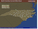
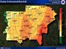
Biggest qpf streak/tongue is the NAM with right at 6 inch stripe up through Wake County/west side Hwy 1. All have 2 inch plus totals I85 east. Most have 20-30mph + gust same area.

qpf_acc-imp.us_ma.png
 
Last edited:
Euro gets the pressure down to 970-975: Canadian & Ukmet in the 980's. American suite ( GFS/Nam) stay above 990. The Euro and Canadian get very Cold air in here Tuesday sub 516 heights. GFS is Cold, but doesn't crash heights quite as much as foreign guidance. Foreign guidance paints best picture for Mtn wrap around, some rogue location east of apps seeing a 10 minute flake. American suite nada.

Enjoyed tracking this and seeing how it plays out. Perfect case study to reference back to if we get to track a SS storm with frozen this year. The They all , especially euro had this coming up the coast, then looked like for a day or two they would ride the apps or piedmont, before adjusting back east yesterday and this morning. Laymans terms we saw the ole NW trend. But it corrected back east it appears. That's seems rare from times past.

Biggest qpf streak/tongue is the NAM with right at 6 inch stripe up through Wake County/west side Hwy 1. All have 3 inch plus totals I77 east. Most have 30mph + gust same area.
We still got 2 days to go I wouldn't be surprised to see another slight Northwest trend as we get closer we almost always do
 
Euro gets the pressure down to 970-975: Canadian & Ukmet in the 980's. American suite ( GFS/Nam) stay above 990. The Euro and Canadian get very Cold air in here Tuesday sub 516 heights. GFS is Cold, but doesn't crash heights quite as much as foreign guidance. Foreign guidance paints best picture for Mtn wrap around, some rogue location east of apps seeing a 10 minute flake. American suite nada.

Enjoyed tracking this and seeing how it plays out. Perfect case study to reference back to if we get to track a SS storm with frozen this year. They all , especially euro had this coming up the coast, then looked like for a day or two they would ride the apps or piedmont, before adjusting back east yesterday and this morning. Laymans terms we saw the ole NW trend. But it corrected back east it appears. That's seems rare from times past.

Biggest qpf streak/tongue is the NAM with right at 6 inch stripe up through Wake County/west side Hwy 1. All have 2 inch plus totals I85 east. Most have 20-30mph + gust same area.

qpf_acc-imp.us_ma.png
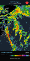
This will verify since there is a white dot centered over my house.
 
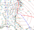
The 12z NAM was much different than 6z. The 12z run is much faster and had precip farther west, but I'm not sure it'll be right. It is still making 200-300 mile shifts in 1 run and now takes the low to near Richmond VA, then back to south of the outer banks of NC before finally tracking northward going through eastern NY state and into Canada.
 
Back
Top