-
Hello, please take a minute to check out our awesome content, contributed by the wonderful members of our community. We hope you'll add your own thoughts and opinions by making a free account!
You are using an out of date browser. It may not display this or other websites correctly.
You should upgrade or use an alternative browser.
You should upgrade or use an alternative browser.
Pattern 12/15-19 Coastal!!!!!
- Thread starter SD
- Start date
Heading to Boone on Tuesday. Looks like I'll see snow on the ground (maybe blowing/whiteout conditions):
Monday
A chance of rain and snow showers before 4pm, then snow showers likely. Partly sunny, with a high near 37. Windy, with a west wind 30 to 34 mph, with gusts as high as 60 mph. Chance of precipitation is 60%. New snow accumulation of less than a half inch possible.
Monday Night
Snow showers likely, mainly between 7pm and 1am. Mostly cloudy, with a low around 17. Windy, with a northwest wind 32 to 34 mph, with gusts as high as 60 mph. Chance of precipitation is 70%. New snow accumulation of 1 to 2 inches possible.
Tuesday
Sunny, with a high near 28. Windy, with a northwest wind 25 to 30 mph decreasing to 14 to 19 mph in the afternoon. Winds could gust as high as 50 mph.
Makeitsnow
Member
Thank God it wasn't cold enough for snow because if it was id be more pissed than I would like to admit lol. I've had a whopping 0.09 of an inch. After I dont know how many model runs showing an inch plus with some href members showing several as late as yesterday.My news station has been saying all week it was gonna be a washout here. According to radar this this is gonna skirt by my area with little to nothing.
gawxnative
Member
I was up early this morning, and did about a 10 minute look at things about 330 ... The Wedge was stronger than forecast coupled with the heaverier convective bands that set up in South/Central GA, it robbed a bunch of the moisture so rain bands stopped about a Dublin to Augusta line . The wedge also dried out any precip with the front as it moved across N Alabama.Thank God it wasn't cold enough for snow because if it was id be more pissed than I would like to admit lol. I've had a whopping 0.09 of an inch. After I dont know how many model runs showing an inch plus with some href members showing several as late as yesterday.
Yes. Do not drive to the high country today unless you want to be disappointed. Tomorrow looks like a banger though. 
Downeastnc
Member
Welp no shortage of rain downstream....wind picking up a bit already.
Stormsfury
Member
4" plus of rain down here. Missed that conveyor belt of storms just off the Charleston coast bolting NNE... Winds consistently in the 25 mph gusts to 35-45 mph.Welp no shortage of rain downstream....wind picking up a bit already.
Pretty nice video from BP: Talks about potential of power outages in the western piedmont of NC: https://x.com/wxbrad/status/1736446478447489442?s=20
Downeastnc
Member
Torando warning in Myrtle Beach


NCHighCountryWX
Member
- Joined
- Dec 28, 2016
- Messages
- 449
- Reaction score
- 1,267
IDSS Forecast Points
www.weather.gov
Shaggy
Member
I was just down at Caswell Beach and it was probably 45 to 55 off the oceanWrightsville beach..
Peak wind gust
89 mph @ 1:25 pm
Wind Average
2 min ago
E 60 mph
5 min ago
ESE 59 mph
10 min ago
ESE 58 mph
rburrel2
Member
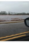
I would assume there is some catastrophic flash flooding in georgetown right now. Local weather stations are over 10 inches now with most of that falling in the last few hours. (and still pouring)
Also looks like myrtle beach and charleston recording their 3rd/4th highest all-time tides. I believe the highest for a non-tropical system for both locations.
Also looks like myrtle beach and charleston recording their 3rd/4th highest all-time tides. I believe the highest for a non-tropical system for both locations.
SWVAwxfan
Member
Flash flood emergency for Georgetown and Horry County SC.
Brick Tamland
Member

Shaggy
Member
There's a significant surge on the cape fear as well. Some low lying roads near my house are now close to over Washing the road