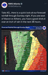
I was afraid of this ...
I talked about a potential of sting jets the other day...
From KCHS
High Winds --
There is a risk for high winds for Sunday. There could be two
distinct wind events; one in the morning with strong low-level
jetting in the
warm sector with the second being a possible sting
jet scenario unfolding for the afternoon/evening. First, winds will
increase along the coast with gusts 40-45 mph
likely. Gusts could be
locally higher along beaches and other exposed areas (such as areas
adjacent to the Charleston Harbor) where fictional influences will
be less. In fact, the 16/12z HREF
mean shows wind gusts nearing 60
mph at times along parts of the Charleston County Coast. A Wind
Advisory has been posted 6 AM until 2 PM for all coastal zones to
account for these winds. There will also be an increased risk to
high-profile vehicles on the elevated bridges around the Charleston
and Savannah
Metro Areas. The second event could unfold during the
afternoon hours as the mid-level
cyclone passes by. There are
signals that a sting
jet feature could develop along the nose of a
descending wind max within the cold conveyor positioned along the
west and southwest flanks of the mid-level
cyclone. Sting jets are
notoriously difficult to forecast, but do have a well documented
history of producing wind damage. It will be interesting to see
how/if this materializes. Additional wind products may be needed if
this feature develops.

