SandySpringswx
Member
- Joined
- Jan 2, 2017
- Messages
- 17
- Reaction score
- 48
Me too.I've transitioned to sleet after a solid three inches of snow.
Me too.I've transitioned to sleet after a solid three inches of snow.

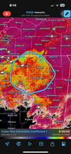
According to RadarScope we’re about to change to sleetFrom my observations off mem's radar, the CC line is starting to go southward just south of Memphis currently. Hope this translates east and you finish strong and send us down the road more cold air!
Ride the lighting as long as you canAccording to RadarScope we’re about to change to sleet

4” here!Me too.
Could be brief, since checking MEM's radar it's sharing the top off of thatAccording to RadarScope we’re about to change to sleet


On the Woodstock/Roswell line we have been rain/sleet for about 30 minutes now.Ripping even more. The boundary that was supposed to shift us to sleet has nearly vaporized and now is south of Rome down into ATL. I think our death band may be priming up

Seems like light drizzle or tiny pellets in cumming right nowRipping even more. The boundary that was supposed to shift us to sleet has nearly vaporized and now is south of Rome down into ATL. I think our death band may be priming up
Interesting because it's about 50/50 snow and sleet here now.Ripping even more. The boundary that was supposed to shift us to sleet has nearly vaporized and now is south of Rome down into ATL. I think our death band may be priming up
Here too.I'm @ 29.1 with steady ZR coming down now
I would love for that one to work out too but potential is never better than actual.I know we all are focused on this one but we have another storm on the 22nd and it looks better potential than this one today. Let’s make it a double.
I'm also getting reports of flurries in Columbia. Not sure of the validity as I'm currently taking care of something at work.Moderate snow Batesburg, SC Saluda/Lexington County line, SC.

Dry air has been impressive but glad you finally are seeing itFINALLY, spotted a flurry here in Clemson, SC. That took some pressure... whew.