JP152
Member
This could be a lot of snow for people who aren't really used to seeing it.

From google:Could you explain this a bit? Novice here. Could a lack of snow growth saturation have to do with convection down in the gulf?
Sent from my iPhone using Tapatalk
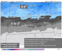
Captain obvious, but that is a big reduction from the 12z. Not what you want to see, but... this is pretty typical in the 72 hours leading up; often pretty big changes. Gotta stay tuned.ICON looks like its zeroing in and makes a lot of sense....mixy mess for RDU but more all snow for GSO to INT
View attachment 160956


I regret clicking on that link. Freezing rain and sleet for N. Alabama.


Yes it was. Off a very strong in situ and very dry airmass (though we had a stronger parent high up in the NE states)Was that the infamous Larry Cosgrove storm?
Wonder why the euro is so light with QPF still.
It's really on an island with that. I'm not buying it. 18z Ukmet only goes out to hr66, but it was juiciest/most amped run yet for it.Wonder why the euro is so light with QPF still.
It's really on an island with that. I'm not buying it. 18z Ukmet only goes out to hr66, but it was juiciest/most amped run yet for it.

what link?I regret clicking on that link Pack. Freezing rain and sleet for N. Alabama.
You're 100% correct that storm produced heavy wet snowflakes that did bring down some trees, particularly west and north of Atlanta. That likely had more to do with the fact that many trees probably still had some leaves on them. While December is meteorological Winter, that storm technically arrived at the tail end of Autumn. I lived in the Decatur area at the time & that was problematic, even with 4-5" of snowfall accumulation.I know it was a totally different storm and setup, but the storm we got in Dec 2017 where parts of NW Georgia got a foot, it was the same type of heavy wet snow this will be. Don’t have to have just freezing rain to lose power, that wet snow will weigh down those pine limbs in a heartbeat . Will probably be widespread power outages

I and having issues with adding quotes, but lets see if this shows up from Packfan.what link?
18z Canadian looks slightly more progressive than 12z. Check it out here if you want. Link
what link?

You could probably go back in this forum and see what models looked likeI wish I had archived what various models looked like before Jan 22 storm. Hopefully euro comes on board for higher qpf soon. Don’t want to squander opportunity for decent storm due to lack of moisture. Although won’t be surprised to see other models trend that direction in the Carolina’s
That one disappeared and then trended back into existence on the NAM probably like 50ish hours outYou could probably go back in this forum and see what models looked like
Anyone have the latest SPIRE model outputs?


18z GFS and Euro comparison:It's ensembles do it too though. Notice the precip dies as it goes east. Not sure what the problem is. AIFS doesnt really have that much precip either and also has less as it hits the Carolinas IIRC.
View attachment 161012


Snow or ICE?