• Hello, please take a minute to check out our awesome content, contributed by the wonderful members of our community. We hope you'll add your own thoughts and opinions by making a free account!

Wintry 1/7/17-1/10/17 Winter Storm

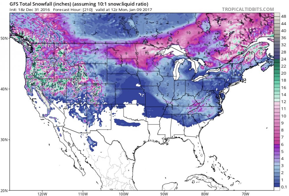
This was from a run on the 20th (not from current run!).
e2d0818b1a053afb7c4744bd16b2986b.jpg


Sent from my SM-J700T1 using Tapatalk
 
NorthGAWinterWx link said:
This was from a run on the 20th (not from current run!).
e2d0818b1a053afb7c4744bd16b2986b.jpg


Sent from my SM-J700T1 using Tapatalk

Typical fantasy snow storm seen it a million times.
 
bhs1975 link said:
[quote author=NorthGAWinterWx link=topic=80.msg5282#msg5282 date=1483162981]
This was from a run on the 20th (not from current run!).
e2d0818b1a053afb7c4744bd16b2986b.jpg


Sent from my SM-J700T1 using Tapatalk

Typical fantasy snow storm seen it a million times.
[/quote]Not so fantasy now, it was on to something.
 
bhs1975 link said:
[quote author=NorthGAWinterWx link=topic=80.msg5282#msg5282 date=1483162981]
This was from a run on the 20th (not from current run!).
e2d0818b1a053afb7c4744bd16b2986b.jpg


Sent from my SM-J700T1 using Tapatalk

Typical fantasy snow storm seen it a million times.
[/quote]

Yes, true, I like to compare past model runs. That run from 06z on the 20th was over done for the snow, think realistically of where the snow will be  and look at the new 0z GFS. And, it's becoming not so fantasy because it's becoming into that 5-7 day window.

Sent from my SM-J700T1 using Tapatalk
 
so we shifted from an Apps runner to a Miller A track. The Ensembles have showed this track area numerous times across all models. After going back and looking, the flip and cold press has been there as well, it was what was causing the suppression on past Ensemble members...interesting set up. My thinking still hasn't changed over the last several days...somewhere between an Apps runner and I95 Special.

Sent from my SM-S820L using Tapatalk
 
tellicowx link said:
so we shifted from an Apps runner to a Miller A track. The Ensembles have showed this track area numerous times across all models. After going back and looking, the flip and cold press has been there as well, it was what was causing the suppression on past Ensemble members...interesting set up. My thinking still hasn't changed over the last several days...somewhere between an Apps runner and I95 Special.

Sent from my SM-S820L using Tapatalk

Well then if it is between those I85 will
Get crushed!
 
Here's a better view of the different totals with the GFS track:

d0880978834991aa0c418a683f5a9d95.jpg


Sent from my SM-S820L using Tapatalk
 
whatalife link said:
SMH! Here come the possible sleepless nights...


Sent from my iPhone using Tapatalk

Got to love it when major winter storms start showing back up a week out.
 
Well, I'm staying up for the Euro, I'm on Accuweather pro and the Euro model data don't come in till late. I'll just discuss along with y'all of what y'all post up from the Euro since I won't have access to the new Euro just yet.

Sent from my SM-J700T1 using Tapatalk
 
Euro about to break our spirit's like Ronda Rousey's.  My heavens she gets paid too much!
 
This storm is full of surprises, and different solutions but yet still a strong storm signal. I say by Monday we should have a better agreement on everything. Great runs tonight so far. I still honestly think the GFS is underestimating the cold
 
Shawn link said:
Euro about to break our spirit's like Ronda Rousey's.  My heavens she gets paid too much!
LOL! It won't break my spirit if I avoid an ice storm...


Sent from my iPhone using Tapatalk
 
Tarheel1 link said:
Larry should like this one! GaWx

Regarding neutral negative (NN) ENSO winters since the late 1800's, ATL has been hit by major ZR or IP 18 times vs only 5 times by major SN (so ~3.5:1 ratio of major ZR/IP to SN). For other ENSO combined, major SN leads major ZR/IP 27 to 17. So, a major ZR there and much of the N GA CAD areas is quite believable. NN is the ENSO king for ENSO ZR/IP's there. This has been and continues to be a worry for the N GA CAD areas and likely stretching into SC/NC.
 
Alrdy looking like diff with energy in west vs 12z. Uh oh.

Edit: yep, starts holding it back there a bit like the 0z gfs showed.  see where she goes.
 
Shawn link said:
Alrdy looking like diff with energy in west vs 12z. Uh oh.

Edit: yep, holding it back there a bit like the 0z gfs showed.  see where she goes.
Sure does...Someone may be headed for glory on this run...But we'll see.


Sent from my iPhone using Tapatalk
 
Back
Top