I have not been able to post an image from Tapatalk since early AM...olhausen said:Anyone else having problems posting pictures from Tapatalk? I wanted to post the latest update from Nashville.
Sent from my iPad using Tapatalk
-
Hello, please take a minute to check out our awesome content, contributed by the wonderful members of our community. We hope you'll add your own thoughts and opinions by making a free account!
You are using an out of date browser. It may not display this or other websites correctly.
You should upgrade or use an alternative browser.
You should upgrade or use an alternative browser.
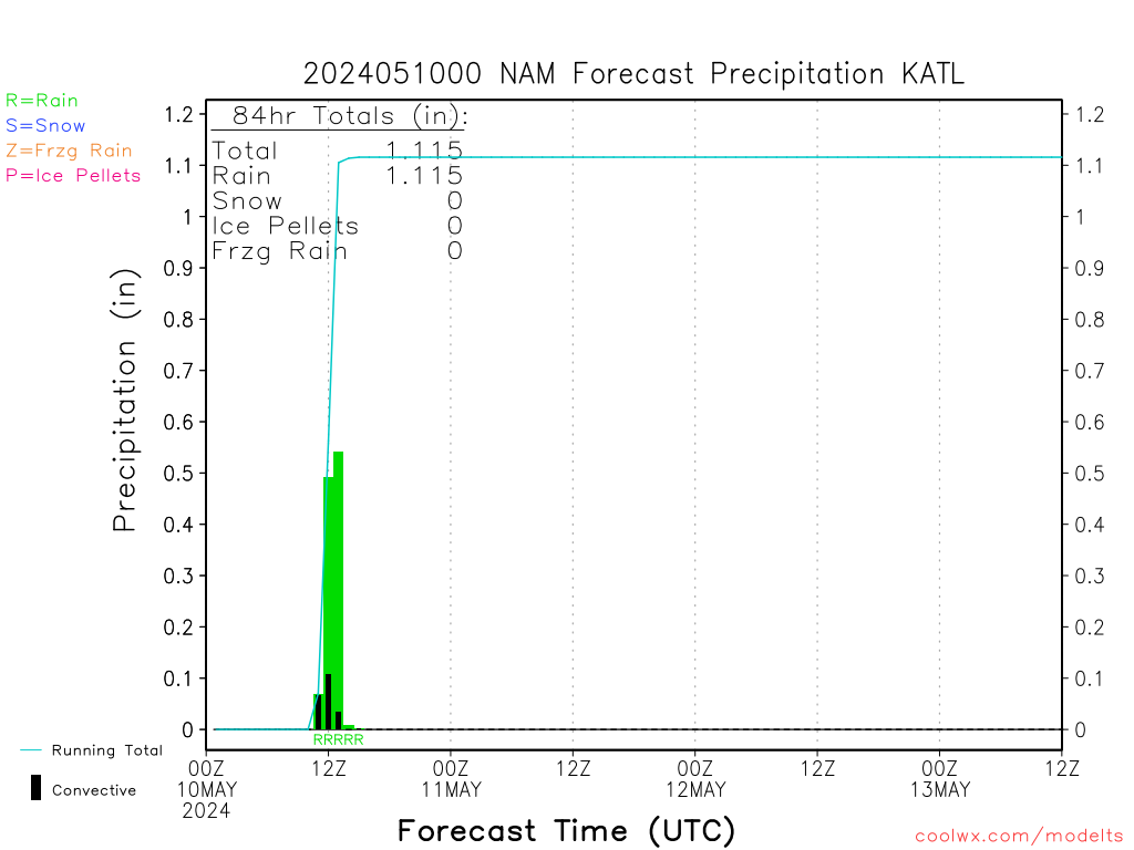
Nam for ATL
The last time I've seen a model be as consistent as the GFS and it's ensembles have been, we saw a similar solution at verification time. I think it's possible that this is the way it goes but with at least a little bit of a north correction.
euro looks pretty food so far. energy looks a tick SW but it looks juicy at the moment
Sent from my SM-G900V using Tapatalk
Sent from my SM-G900V using Tapatalk
Storm5 said:they are tossing the 00z run. not the ukie in generalbouncycorn said:WPC says toss the ukie
Sent from my SM-G900V using Tapatalk
What was their reason for tossing the 0Z UKMET run?
Storm5 said:all 12z gefs members are hits here except one.
Sent from my SM-G900V using Tapatalk
Seriously, I had given up. Where is the snow?
If anything I think the Euro is stronger with the s/w out west compared to other models thus far....
euro looks similar to 00z so far
Sent from my SM-G900V using Tapatalk
Sent from my SM-G900V using Tapatalk
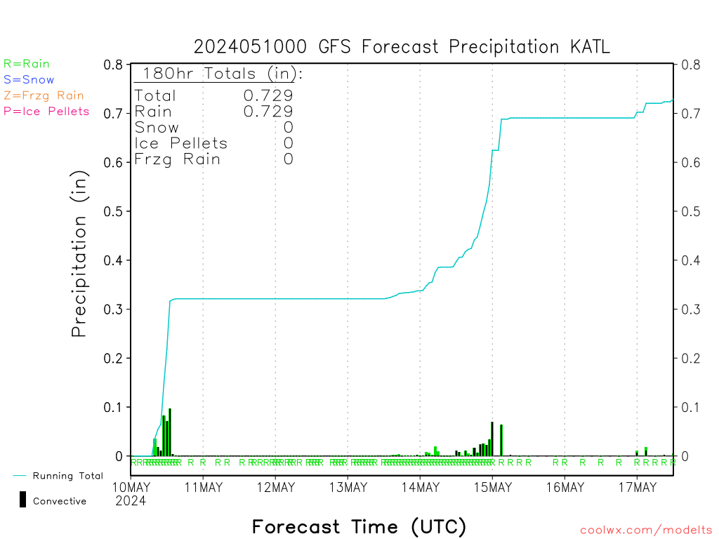
WXinCanton said:GFS for ATL
That's meh...unless I'm reading it wrong.
Sent from my iPhone using Tapatalk
swbamaweatherguy said:Does anyone have the Map for ice off the 12z GFS
Sent from my iPhone using Tapatalk
What county are you from
ATLWxFan said:WXinCanton said:GFS for ATL
That's meh...unless I'm reading it wrong.
Sent from my iPhone using Tapatalk
Almost 5 inches of snow
stormcentral said:Lol WTVC channel 9 calling for a dusting KCHA & SE TN ?
Unfortunately, that is what most of the guidance I've seen is pointing to... Even the Euro is not showing the "up to" 3 inches that WRCB is saying. I'm hoping the Hi-Res models save us, but right now I'm having a hard time getting on board with anyone that says more than an inch for CHA. Obviously, things can still change and I hope they do!
EDIT: out of the American models I've seen so far, the NAM 4km is the big winner for Chattanooga with a whopping 0.725"...
ATLWxFan said:WXinCanton said:GFS for ATL
That's meh...unless I'm reading it wrong.
Sent from my iPhone using Tapatalk
Its like 5 inches of snow lol not meh
ATLWxFan said:WXinCanton said:GFS for ATL
That's meh...unless I'm reading it wrong.
Sent from my iPhone using Tapatalk
That's liquid so 10:1 snow ratio for that area would be roughly 4 1/2 inches of snow I believe is how that works
WXinCanton said:ATLWxFan said:WXinCanton said:GFS for ATL
That's meh...unless I'm reading it wrong.
Sent from my iPhone using Tapatalk
Almost 5 inches of snow
Am I reading it wrong? I thought it was cumulative.
Sent from my iPhone using Tapatalk
That is all in liquid QPF, so that is a big hit to ATLATLWxFan said:WXinCanton said:GFS for ATL
That's meh...unless I'm reading it wrong.
Sent from my iPhone using Tapatalk
Got this from our subforum at another site. Very interesting if true.
"GaWx did some research on Lows taking the path of the GFS shows and found it happened once every 10 years since 1950. Last time was Feb 2010. It only happened one time ever with a +AO/NAO which I believe we are in now."
Sent from my iPhone using Tapatalk
"GaWx did some research on Lows taking the path of the GFS shows and found it happened once every 10 years since 1950. Last time was Feb 2010. It only happened one time ever with a +AO/NAO which I believe we are in now."
Sent from my iPhone using Tapatalk
A half inch liquid equivalent falling as snow isn't meh, IMO.ATLWxFan said:WXinCanton said:GFS for ATL
That's meh...unless I'm reading it wrong.
Sent from my iPhone using Tapatalk
accu35 said:swbamaweatherguy said:Does anyone have the Map for ice off the 12z GFS
Sent from my iPhone using Tapatalk
What county are you from
Washington county
Sent from my iPhone using Tapatalk
And that's assuming all of it sticksmalak05 said:ATLWxFan said:WXinCanton said:GFS for ATL
That's meh...unless I'm reading it wrong.
Sent from my iPhone using Tapatalk
That's liquid so 10:1 snow ratio for that area would be roughly 4 1/2 inches of snow I believe is how that works
1Z Euro is slightly colder in the prestorm stages.
probs should note i'm half joking, sorry if i came across as a twit. nevertheless it would be quite the failure for the gfs if it does turn out to be wrongFLO said:If it verifies does that mean we should never trust the Euro again since it is showing the opposite?mydoortotheworld said:SoutheastRidge said:Boy if the GFS ends up being wrong on this it would be a huge setback for that model and I dont think I would ever trust it again
yeah especially since it has been so consistent. if it turns out to be wrong... then it has been consistently wrong... and is therefore garbage
edit: and also for the euro too. in all seriousness don't think this will affect my overall perception of the models negatively, it is what it is
12Z Euro is a little colder and the sfc low is slightly south of the 0Z Euro. The high pressure to the north is a little stronger.
Ron Burgundy said:A half inch liquid equivalent falling as snow isn't meh, IMO.ATLWxFan said:WXinCanton said:GFS for ATL
That's meh...unless I'm reading it wrong.
Sent from my iPhone using Tapatalk
Weenie mistake. I didn't realize it was liquid equivalent which certainly makes sense and certainly ain't meh.
Sent from my iPhone using Tapatalk
Thru 48 flat with little stronger slp
mydoortotheworld said:probs should note i'm half joking, sorry if i came across as a twit. nevertheless it would be quite the failure for the gfs if it does turn out to be wrongFLO said:If it verifies does that mean we should never trust the Euro again since it is showing the opposite?mydoortotheworld said:SoutheastRidge said:Boy if the GFS ends up being wrong on this it would be a huge setback for that model and I dont think I would ever trust it again
yeah especially since it has been so consistent. if it turns out to be wrong... then it has been consistently wrong... and is therefore garbage
Especially considering it's shown the same idea for several runs with a few tweaks here and there.
Even more stream separation this run out west, vort max looks stronger thru 48-60 HR
Yeah it's gonna be a little south of 00z
Sent from my SM-G900V using Tapatalk
Sent from my SM-G900V using Tapatalk
precip shield a little north of 00z for us back towards my area
Sent from my SM-G900V using Tapatalk
Sent from my SM-G900V using Tapatalk
Storm5 said:Yeah it's gonna be a little south of 00z
Sent from my SM-G900V using Tapatalk
Could it be tipping it's cap to a more GFS solution???
Sounds like maybe a little GFS trend
Dare I say it, is the Euro about to blink.
the 72 hour position of the 12Z Euro is about 50 miles south of and about 1 mb weaker than the 0Z Euro.
Make sure Brick isn't about jump.
The EURO may just be starting to cave some to the GFS. Euro looks further south this run.
Sent from my XT1585 using Tapatalk
Sent from my XT1585 using Tapatalk
Im worried about a warm nose
same result for those of to the west as 00z . but I'll take that run .
Sent from my SM-G900V using Tapatalk
Sent from my SM-G900V using Tapatalk
This run definitely trended in the right direction in more ways than one thru 72 HR. Stronger vort max, more amped wave, and a degree or two colder everywhere esp over GA & the Carolinas. Good start
Lots of precip through Midlands of SC wasted with warmer temps before changeover.