Eastern Carolinas need to watch out.. remember what the Fv3 showed the other day for eastern SC and NC?
-
Hello, please take a minute to check out our awesome content, contributed by the wonderful members of our community. We hope you'll add your own thoughts and opinions by making a free account!
You are using an out of date browser. It may not display this or other websites correctly.
You should upgrade or use an alternative browser.
You should upgrade or use an alternative browser.
Wintry 1/26-1/28 Winter Storm Potential
- Thread starter deltadog03
- Start date
NBAcentel
Member
I might be to excited, but I think even areas as far west as Charlotte needs to watch this
Fountainguy97
Member
Impressive.
Fountainguy97
Member
Dynamics taking control. Temps won’t be an issue unless she comes onshore.


NBAcentel
Member
Dynamical cooling taking affect judging by temps in the sheild of precip
snowlover91
Member
NAM looks a bit too dry at the surface given this upper level look at 5H. 7H is similar.

I need to go to Cape Hatteras, so I can watch more cold rain!?
When is this storm potential? Monday?? Definitely positive trends today for the Eastern Carolinas!
When is this storm potential? Monday?? Definitely positive trends today for the Eastern Carolinas!
Fountainguy97
Member
NAM looks a bit too dry at the surface given this upper level look at 5H. 7H is similar.
View attachment 13305
It’s been a bias this winter as a whole too be too dry. This is a tightly wound system though. Would be a terrible cutoff.
carolinachaos
Member
With all this being said what is the time frame?
Sent from my SM-N950U using Tapatalk
Sent from my SM-N950U using Tapatalk
good lord. what a shift. it is 72hr nam at the point of it bombing offshore but i would love to see the 18z suite follow suit.
Fountainguy97
Member
Keep in mind our northern energy is just now forming. It’s not even really much of a solid piece yet. But by 06z tonight it will be organizing. Into the piece of energy most models have tracking into the US.
This means the door is still open to change tonight as our pieces are still in development stage.
This means the door is still open to change tonight as our pieces are still in development stage.
I thought this system was over and done with,but maybe not?! If NAM and other models continue have a Quicker phase between the Northern Stream and the Southern Stream,this could maybe be interesting even for Columbia. I still expecting nothing for me area,but maybe Florence SC, Lubmberton NC to Greenville could be getting a snow event?
snowlover91
Member
good lord. what a shift. it is 72hr nam at the point of it bombing offshore but i would love to see the 18z suite follow suit.
The early stream interaction happens hours 18-36 which is in the range where the NAM should be preferred over globals IMO. It shifted our northern energy west enough to pull the southern energy north and give us a much improved look. We still have room for improvement as it's still a bit slow to go neutral to negative.
3k nam at 60, juiced up.

snowlover91
Member
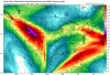
Who can spot the dynamic cooling on the 3km NAM?

Earlier I thought this would be at best a few rain showers for the Outer Banks, but then I realized we're still nearly three days out, and radiational cooling will likely help offset the initially warm surface temperatures. We might only be about a 100 mile west shift away from a significant winter storm for the Coastal Plain of North Carolina. Still think significant QPF is a long shot for RDU and points west though.
We still got time.ugh wish we could get that moisture up to Columbia
B
Brick Tamland
Guest
Just when you thought the storm was dead...

snowlover91
Member
All that needs to happen to bring the qpf further inland is a bit quicker/cleaner phase of the northern and southern streams so that this will go neutral to negative tilt faster. The system will also slow down a lot when this happens. The 3km has this going neutral by hour 60; ideally those inland want it going negative by this point if not a little sooner. It won't take much to get that change either as it only needs a slightly better/faster phase to get there...

icon still offshore with precip but looks a bit slower?

NBAcentel
Member
Even tho globals are important, short range models will do better now since that possible phase is under 60 hours
snowlover91
Member
ICON looks a little slower and better with the interaction but it doesn't really reflect at the surface. The RGEM has a different look as well with how it handles the energy interaction. Models are going to struggle to figure this out.
Webberweather53
Meteorologist
Reel. It. In.

ForsythSnow
Moderator
Wow those jumps are massive. Too bad it can't jump twice more closer and end up right along the coast or a bit more inland.
MichaelJ
Member
Raleigh people do not want it on the coast or inland because mixing will be a factor, for them they want to see it 50-75 miles offshore.Wow those jumps are massive. Too bad it can't jump twice more closer and end up right along the coast or a bit more inland.

Its happened before. This is the ETA which is todays NAM. I want give away what time in history this happened.

snowlover91
Member
GFS through 30 is a shift towards what the NAM showed.
precip is closer at 57 than 12z but not nearly as good as the nam. just offshore.
snowlover91
Member
precip is closer at 57 than 12z but not nearly as good as the nam. just offshore.
At this stage the globals begin to have a bit less usefulness and the meso models will be more helpful in trying to figure out how this energy will interact. I like the NAM/RGEM blend... having said that the GFS and ICON both did shift to an earlier interaction and pulled the southern wave north some.
Fountainguy97
Member
Gfs anything tick better. Right on the cusp of a bigger move but not quite there. There is definitely a bit of concern that the nam is bein the nam.
But gfs did continue the trend
But gfs did continue the trend
Kylo
Member
Need that Atlantic ridge to do its thing. It usually haunts us inside 60 hours and now it can really help.

Webberweather53
Meteorologist
Given the GFS' canonical biases wrt handling precipitation on the NW side of coastal cyclones (which is even worse than other NWP models) this run is clearly suggesting a threat for wintry precipitation in the coastal plain of NC and possibly SC. Notice how much slower the wave is now too, obvious nod to the more amped/NW solutions.
This is almost game on for the I-95 & US-1 corridors

This is almost game on for the I-95 & US-1 corridors
snowlover91
Member
To illustrate the differences in how the models handle the energy interaction, here is a comparison of the 18z GFS vs the 18z 3km NAM (which I prefer for these complex setups). Keep in mind we are less than 3 days out and seeing significant differences in how they handle the energy.

3km NAM

3km NAM
Fountainguy97
Member
Good trend in fv3! Maybe it can sniff out some details the old gfs misses
Webberweather53
Meteorologist
Another nice catch by @Jon
To everyone who thinks &/or thought our models are/were good enough several years removed from the Dec 2010 event where we don't get last minute surprises inside day 3-4 like this, this system clearly shows they can still happen and we have a lot of work left to do.
To everyone who thinks &/or thought our models are/were good enough several years removed from the Dec 2010 event where we don't get last minute surprises inside day 3-4 like this, this system clearly shows they can still happen and we have a lot of work left to do.
Not a bad sounding at 72 for mby from the nam

Sent from my SM-G955U using Tapatalk

Sent from my SM-G955U using Tapatalk
ajr
Member
Avalanche
Member
Mike Maze did mention we could see some high thin whispy cirrus clouds from this, and the outer banks could experience some shower activity. Still clinging on to anything I can.
Avalanche
Member
Help me out Fountain. To me it looks like there is less buckle in the jet and more straight line energy on the second run, wouldn't that make it less appealing for us? I'm a novice so please excuse my ignorance.Good trend in fv3! Maybe it can sniff out some details the old gfs missesView attachment 13320