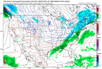
GSP is leaning toward the GEFS it seems and not buying the Euro suite. I seem to agree at this point. Still not buying the phase, but we'll see.
The models also start disagreeing with the timing of an incoming
h5
s/w
trof and it`s interaction with the frontal zone Fri thru the
weekend. The
GFS soln is faster and has little
sfc wave development
along the
front, thus less moist adv into the region and much less
chance of wintry precip reaching the
FA. The
ECMWF and the CMC on
the other hand indicate a slower progression of the upper
trof and
more time for a
sfc wave to develop and bring a good
amt of deep
layered
moisture into the area. If this scenario pans out, the
generated precip would interact with a a cold and dry
sfc layer,
which would support a period of wintry mix then mostly snow across
most of the
FA. Still much uncertainty exists with this system and
the models have been going back and forth on these solns.
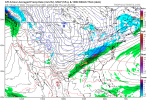
Additionally,
the GEFS members dont provide a good clue on the
pattern one way or the other. More than half the perturbations
indicate no good chance precip reaching the area and the others are
mostly skimpy on wintry precip amts. Thus, low-end to nil PoPs will
continue to advertised for now with this weekend system.


.png")
 , with a second system Tues, many details yet to be worked out.