Congrats to all of you cashing in … especially when it looked as all hope was lost.
-
Hello, please take a minute to check out our awesome content, contributed by the wonderful members of our community. We hope you'll add your own thoughts and opinions by making a free account!
You are using an out of date browser. It may not display this or other websites correctly.
You should upgrade or use an alternative browser.
You should upgrade or use an alternative browser.
Wintry 1/20 - 1/23 Winter Storm
- Thread starter packfan98
- Start date
EastNC
Member
Sctvman
Member
Primetime ran a little late but not denied.

Stormsfury
Member
Same thing happening here in Goose Creek. ZR/IP/Very Small Flakes
Total fail in Aiken. We somehow got dry slotted big time. All went N/S of us. Unreal to be honest. Radar would look great then get to Aiken just split. Barely covered the grass.
Is sleeting in Mnt Pleasant!!
I think it is a little. It filled in over Sumter County about 10 minutes ago!Is the back end east of Columbia building back more precip? It sure looks that way.
Sent from my iPhone using Tapatalk
 Hillsborough st in Raleigh
Just got in from taking some measurements. I’m going to call it 2.5”, got measurements between 2-3” depending on where I took it. Honestly thought we had a bit more than that from eyeballing it, but I guess not. It’s been a while since I’ve seen snow IMBY, so I’m out of practice! Ah well, it was fun! Most snow I’ve seen since 2015, and the coldest snow since 2014. Now I really want to see a big dog again!!!
We’re still getting some light snow/flurries, but I can’t imagine it adding up to anything much further.
I was hoping to try sledding on this tomorrow, but I’m not sure 2.5” is going to be enough to allow that or not…

We’re still getting some light snow/flurries, but I can’t imagine it adding up to anything much further.
I was hoping to try sledding on this tomorrow, but I’m not sure 2.5” is going to be enough to allow that or not…
It's been sleeting here in EI for a while now. When it was just ZR, the streets "looked" ok and when I walked out on 58, it seemed ok. Now everything is white with ice and slick enough for you to fall and bust your a@@.
olhausen
Member
Awesome pictures from out there in north and South Carolina! Glad so many have cashed in so far this winter. No snow falling here but it’s cold as witches tit!
Downeastnc
Member
Getting smashed....hope to keep it go I ng another hr at least but time is running out.
 .
.
.Getting some tiny flakes mixing with the sleet now. Hoping I see a changeover to snow soon.


I believe we ended up with 2.5 inches near Clemson / Hardscrabble in NE Richland (34.1° N, 80.9° W). Interesting enough, even with it at 27 degrees we had quite a bit of melting off roads and sidewalks.
Sent from my iPhone using Tapatalk
Now the precip is ending. Snow was never able to fully switch on. Sleet was the primary precip. I guess I was just too close to the coast. Still was a really cool event to experience!
David Lowery
Member
I ended with 4 inches here
I'm seeing a lot of 1 to 2 inches. For many I made a quick measure roughly last night and when I did it was around an an inch and 1/4 but don't know how much was on the final final band.
About 1/4 inch of ice here. We still have lights and only isolated power outages in the area. Hoped to see some token flakes this morning, but it still ended as a freezing rain/sleet mix at about 6am.
packfan98
Moderator
Looks to be around 1.5” here. Beautiful! One more good storm will make this an ‘A’ winter. If it happens next weekend it becomes ‘A+’
Cad Wedge NC
Member
Picked up 1 inch here. 18 degrees this morning
raine1212
Member
MichaelJ
Member
About an inch and a half here, currently 15.8/3.5. Very happy for folks who don't normally win in these situations, did in this case. 8-10 times in Winston-Salem we outperform the Central/Eastern part of the state so this is only fair. Have fun out there guys!
Heelyes
Member

Close to about 2 inches here. Similar to the last storm


Bannerdude
Member
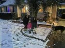
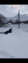
Averaged just under 4" in a bunch of spots in the yard. This was a fleeting moment that we got the dog to sit still.

Finished with just about 2.75” here. The rates between 10-11pm were awesome.
carolinachaos
Member
2.5” of snow here in Florence,SC after hours of freezing rain and sleet before the transition.
Sent from my iPhone using Tapatalk
Sent from my iPhone using Tapatalk
rusrius
Member
Congratulations to everyone. Personally I ended up with between 2 and 2 1/2 inches depending on where I took it. After 5 years of not haven seen a snowflake, I will thank my lucky stars and run with it.
Attachments
Shaggy
Member
Got somewhere between 3.5" and 4". Biggest snow since December 2018.

Warm nose finally going away, too little too late
jovialweather
Member

Nice event. Fun drives last night and this morning taking my wife to work. I'd say somewhere between 2.5 and 3 inches here in north Raleigh. Thanks to everyone for the great insight leading up to this one!
Officially 1" here NW of GSO...nice coating. Oh, it's 16degF out there too.
Downeastnc
Member
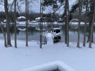
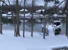
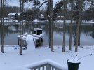
For 2-3 hrs last night between say 1-4am it absolutely dumped....we just need to learn how to do that for more than a few hrs every storm again.....looks like a general 4-5" total, powdery dry snow so it drifted a bit even so a few places 6-8" deep....