This radar depiction just seems odd the way this zone sets up on the HRRR .. don’t know how to explain it but we should see heavier returns further west 
That’s beyond crazy… 6 hours apart, but it literally just moved the western extent from the coast line to CLT… can you imagine if we ever saw shifts like this with a hurricane?View attachment 109076
cmon man. we're 9 hours in and it's a 200 mile shift.
Could be bright banding from sleet.This radar depiction just seems odd the way this zone sets up on the HRRR .. don’t know how to explain it but we should see heavier returns further west View attachment 109092
Looks like precip field expanded but less density in previous areas
it happens. the hypothetical hurricane analogy here is the 10 mile shift west that makes the compact category 4 coming in at an oblique angle landfall in tampa instead of naplesThat’s beyond crazy… 6 hours apart, but it literally just moved the western extent from the coast line to CLT… can you imagine if we ever saw shifts like this with a hurricane?


Maybe virga, but radar says we’ve got ice into the GOM. Gonna be a good day for somebody in the Carolinas.View attachment 109095
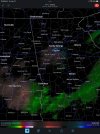
I see that concord jackpot in CLT metro ?Really think the fv3s depiction is on the money View attachment 109094View attachment 109096View attachment 109097View attachment 109098

absolutely. if the nam is to be believed and things begin at 4ish you've got every ingredient needed for snowjam 2022For what it's worth. East TN is experiencing a flizzard event right now. This limited moisture is having no problem putting down some light snow.
Of course some upslope helping. But still a good sign for you guys to the east!
If Raleigh-Durham area starts seeing snow around rush hour it may get pretty rough for commuters.
.NEAR TERM /THROUGH TONIGHT/...
As of 930 AM Friday...
Just minor changes this morning as we await a full suite of new 12z-
initialized guidance. Observational datasets confirm the near term
forecast trends. The latest surface analysis shows the frigid high
nosing strongly down through central NC with plenty of dry air
advection, including single-digit dewpoints just to our N. Skies are
just cloudy, with radar showing spotty elevated returns across the S
half, although most of this is likely not reaching the ground given
the somewhat dry subcloud layer noted on 12z soundings. Will
maintain low chance pops across the SE well into the afternoon,
before trending pops up with a NW expansion as we approach the
evening. Any changes to the advisory or warning will wait a few more
hours when further high res guidance can be fully considered. Expect
temps to hold firm or rise just a degree or two today, yielding
daytime highs of 27-34. Current brisk winds from the NNE and NE with
occasional gusts to around 20-25 mph will persist through the day as
the dense air pours in with a strong ageostrophic component, which
will keep wind chills in the upper teens to mid 20s for much of the
day. -GIH
from RAH .. only a 2% chance to get 4 or more inches …. I smell a bust
The NAM would be an absolute disaster.absolutely. if the nam is to be believed and things begin at 4ish you've got every ingredient needed for snowjam 2022


Too bad we cant make up the cancelled outdoor game tonightCanes are home tonight. Gonna be a traffic nightmare in Triangle
That would truly be an awesome sightToo bad we cant make up the cancelled outdoor game tonight
I dont think many people went to work today. Schools are also out. Traffic this morning was non-existent.Canes are home tonight. Gonna be a traffic nightmare in Triangle
I just imagine some abject, sheer panic thereIP report down in Mobile AL.
Yeah, the airport is reporting freezing drizzle/fog again right now. I got some light returns over me, but I’m not seeing anything so far.Looks to be some very very light returns over Atlanta right now. Doesn't appear that anything is reaching the ground from what I can tell.
UK has been steady bringing snow all the way to the coast. I would be interested to see a forecast sounding from that model to see why its missing the warm nose or if its just counting all frozen precip as snow. It would be awesome if it verified, but it's really the only model that shows significant snow here at the coast.
Mobile, AL area is under a WWA it was probably issued very recently this morning tho. I don’t remember them being under one last night.I just imagine some abject, sheer panic there

| NOAA-NWS-ALERTS-GA1263DD2353B8.SpecialWeatherStatement.1263DD243580GA.FFCSPSFFC.976a6a7e42637d214043ebe552e30eeffrom [email protected] | |||||
| Sent: | 09:22 EST on 01-21-2022 | ||||
| Effective: | 10:04 EST on 01-21-2022 | ||||
| Expires: | 15:00 EST on 01-21-2022 | ||||
|
 ️ and they will only slow build and grow before expanding east into the Piedmont. ?