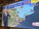
• Hello, please take a minute to check out our awesome content, contributed by the wonderful members of our community. We hope you'll add your own thoughts and opinions by making a free account!

Wintry 01/28-29/2022 Winter Weather Potential

For folks east of 95 in NC, more times than not SLP corrects west inside 48hrs, delta PVA looks to max around Myrtle before going offshore currently, if it’s Savannah we get smoked, it’s not far off in the grand scheme and evident by volatility in guidance. A late bloomer but it’s still a solid look inside day 3, I’m at the table with ante.

500hv.conus.png

ref1km_ptype.conus.png

@Faco Thomas Google it?

https://en.m.wikipedia.org/wiki/Positive_vorticity_advection
 
Last edited:
3K is really picking up on the ULL passage and shows more moisture associated with it. Dropping a solid amount at hour 60 with at least a couple more hours to go. Definitely could drop a quick 1-3” for a lot of areas in the western carolinas
I could definitely see this being a widespread 1-3” type event for the NC Foothills, Piedmont, Sandhills, as well eastern SC upstate. The key would be where any convective elements set up as those would create some very intense rates in very short amount of time… in the February 2013 event CLT had 3.3” with 2.7” of it falling in just about 1 hour
 
For folks east of 95 in NC, more times than not SLP corrects west inside 48hrs, delta PVA looks to max around Myrtle before going offshore currently, if it’s Savannah we get smoked, it’s not far off in the grand scheme and evident by volatility in guidance. A late bloomer but it’s still a solid look inside day 3, I’m at the table with ante.
I was ready to fold with the last storm when the storm practically went poof around 24-30 hours out only to make the drastic NW trend. There will be a NW trend of some kind, always is. Just a matter of how much.
 
UK looks great, especially if you live under that 1” qpf band in Greensboro.

View attachment 110668
Late phasing streamer dropping in on the UKMet saves the day for Greensboro ?

SvTSoEn.gif
 
Sure NAM was still solid if you ignore the trend which is hard to do

View attachment 110726
Yea this isn't a good trade off even for central NC. The phase scenario was the way to go and unfortunately it trended in the wrong direction from Triad out to the big pond. Folks counting on ULL best get ready for dry bones let down IMO. Hopefully I'm wrong
 
RGEM giving us scraps…lucky for it…we love the scraps

View attachment 110731
I’m vindictive, so I do kind of love to see the ULL trending stronger over us to give a small/moderate event while New England gets screwed over. Haha.

Definitely an increasing consensus and better amounts showing up with the ULL passage today. This is occurring across all models, and if it trends better we could be looking at a nice event from that alone.
 
I can't stop looking at the 3k Sim satellite with the rapidly cooling cloud tops over nc and the banded precip
From hr 55-60 Keeps those deep Clouds up Hwy 1 corridor N/S all the way to the coast. But from there back west its all thin milky. 3knam
 
I’m vindictive, so I do kind of love to see the ULL trending stronger over us to give a small/moderate event while New England gets screwed over. Haha.

Definitely an increasing consensus and better amounts showing up with the ULL passage today. This is occurring across all models, and if it trends better we could be looking at a nice event from that alone.
You read my mind bro lol I'll take all the scraps I can get especially if I end up with more than parts of new england aside from coastal areas lol I've scored and been burnt with ull but the lee side meso low gives me hope for the foothills and peidmont.
 
From hr 55-60 Keeps those deep Clouds up Hwy 1 corridor N/S all the way to the coast. But from there back west its all thin milky. 3knam
Still decent soundings west of 1 with plenty of lift in a fairly saturated dgz. Might not be ripping mashed potatoes like it would be east but not a bad look
 
Still decent soundings west of 1 with plenty of lift in a fairly saturated dgz. Might not be ripping mashed potatoes like it would be east but not a bad look
Yes it’s a very good look. The other thing is… this isn’t just an ULL… this a Lee side trough/ULL… it’s a set up that has done very well for the Piedmont over the years and it’s something that has and is gaining more support from models… both operational and ensembles
 
Back
Top