Bone dry here but hopefully this virga will moisten the column for the main event
-
Hello, please take a minute to check out our awesome content, contributed by the wonderful members of our community. We hope you'll add your own thoughts and opinions by making a free account!
You are using an out of date browser. It may not display this or other websites correctly.
You should upgrade or use an alternative browser.
You should upgrade or use an alternative browser.
Wintry 01/28-29/2022 Winter Weather Potential
- Thread starter weather nerd
- Start date
Flotown
Member
Snow flurries in Florence al at 40 degrees
Flotown
Member
Well a few anyways 5 miles nw of florence..lolSnow flurries in Florence al at 40 degrees
Right on cue ? 
Turner Team
Member
Light Rain and 38 degrees here in Roanoke.
LukeBarrette
im north of 90% of people on here so yeah
Meteorology Student
Member
2024 Supporter
2017-2023 Supporter

All snow up here on Mill Mountain at 1600 feet. It’s a mix in the valley right now so I decided to drive up here. This picture perfectly shows where the melting layer is. If it was all snow in the valley you wouldn’t be able to see the city below. The melting layer is hovering around 1000 feet and will get lower in time.
Its the real deal. Ripping in the mtnslol that stuff coming out the mountains is starting to look like a summer Lee trough multicell cluster on the HRRR View attachment 111305
Come on Euro: get it right like you use to lol

NBAcentel
Member
Quick update map 
Lukes image shows the snow that we still have on the ground. Most of that has thawed/frozen for the past 12 days...a bit of that up on top of Mill Mountain is making it down. Just stepped outside at 3:39 and we have small flakes making it to the surface...about 1000' where I am at downtown. Feels wet out there, so dry air isnt a problem..View attachment 111310
All snow up here on Mill Mountain at 1600 feet. It’s a mix in the valley right now so I decided to drive up here. This picture perfectly shows where the melting layer is. If it was all snow in the valley you wouldn’t be able to see the city below. The melting layer is hovering around 1000 feet and will get lower in time.
ajr
Member
It's really coming down near Sugar Mountain -- definitely looks better than radar returns
Blue_Ridge_Escarpment
Member
Can confirm here at the house.Its the real deal. Ripping in the mtns

LukeBarrette
im north of 90% of people on here so yeah
Meteorology Student
Member
2024 Supporter
2017-2023 Supporter
Lukes image shows the snow that we still have on the ground. Most of that has thawed/frozen for the past 12 days...a bit of that up on top of Mill Mountain is making it down. Just stepped outside at 3:39 and we have small flakes making it to the surface...about 1000' where I am at downtown. Feels wet out there, so dry air isnt a problem..
 30 minutes later and the snow is getting much lower
Blue_Ridge_Escarpment
Member
HRRR is initiating horribly each run with precip back in TN
StormStalker
Member
A few flurries in downtown Florence on campus at UNA.
NBAcentel
Member
HRRR keeps shifting west
- Joined
- Jan 23, 2021
- Messages
- 4,604
- Reaction score
- 15,203
- Location
- Lebanon Township, Durham County NC
That was a really good QPF run on the HRRRRRRRR
lexxnchloe
Member
How so? I was looking at some of that hitting se NC later. One model showed that.That was a really good QPF run on the HRRRRRRRR

packfan98
Moderator
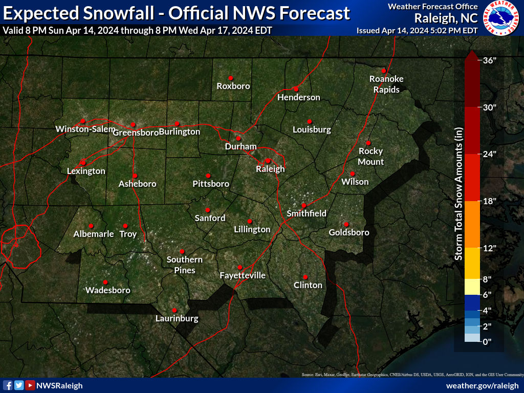
EDIT: Morning prediction from NWS. If I were predicting, I’d probably cut those in half.
Last edited:
Lowtown
Member
This is from 3:47 AM. They are supposed to be putting out an update any minute, but it sounds like they plan on lowering totals a little if anything. We'll see...Latest prediction from NWS. If I were predicting, I’d probably cut those in half.

olhausen
Member
Snow accumulated quickly here. Did not expect this even though it’s not a lot. Went from 40 and sunny to 31 and snowy in under 2 hours.


NBAcentel
Member
Starting to see signs of convection forming in the mountains/foothills
Drscottsmith
Member
Duncan SC
Light (very light) rain
49.3/27.1
Light (very light) rain
49.3/27.1
NBAcentel
Member
The mountains/foothills are about to start lighting up 
NBAcentel
Member
Seems like the hrrr is rushing the development/to fast with it as well
L
Logan Is An Idiot 02
Guest
Is that a good or bad thing? LolSeems like the hrrr is rushing the development/to fast with it as well
NBAcentel
Member
Neither. Just a later start the the hrrr is to fastIs that a good or bad thing? Lol
I have seen drops or precip falling on my car window .. very light but hmmm
NBAcentel
Member
Woooo it’s coming back baby 
L
Logan Is An Idiot 02
Guest
Yeah I have sprinkles as welI have seen drops or precip falling on my car window .. very light but hmmm
carolinachaos
Member
These Snow reports must be in Florence AL… remember to add your state as there is a Florence, SC as well.
Sent from my iPhone using Tapatalk
Sent from my iPhone using Tapatalk
D
Deleted member 1449
Guest
Rain drops and 42 degrees here.
Light light flurries on top of HendersonvilleThe mountains/foothills are about to start lighting up View attachment 111327
olhausen
Member
20 minutes north at work and Thers nothing. Wow
NBAcentel
Member
Temp starting to drop, 44F from 48F a hour ago
NCHighCountryWX
Member
- Joined
- Dec 28, 2016
- Messages
- 700
- Reaction score
- 1,921
 501pm totals cut by GSP