I think the less of a coastal impact there is the more that convective line moves east .. at least that tends to look like what the models portray
-
Hello, please take a minute to check out our awesome content, contributed by the wonderful members of our community. We hope you'll add your own thoughts and opinions by making a free account!
You are using an out of date browser. It may not display this or other websites correctly.
You should upgrade or use an alternative browser.
You should upgrade or use an alternative browser.
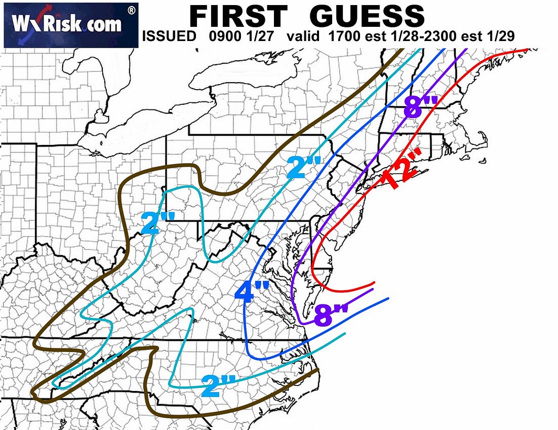
Wintry 01/28-29/2022 Winter Weather Potential
- Thread starter weather nerd
- Start date
We are all going to be fighting over the 850/700mb convergence axis tomorrow to see who gets a dusting and who gets 1-3

They're used too big storms.40" for Boston on the NAM. This sounds like a good idea but after about 24 hours it's going to feel suffocating not being to go anywhere.
View attachment 111049
Roxboro doing well there, what else is new? I’d actually cash out with that, 2-3” for here, seems about as good as we can do at this point.
If you are trying to throw a hail Mary for tomorrow evening with the coastal watch this
lexxnchloe
Member
I would appreciate it if you could explain what im watching. I assume those circles mean areas of alot of snow but not sure.If you are trying to throw a hail Mary for tomorrow evening with the coastal watch thisView attachment 111050
jtgus
Member
Watch or look at? Is it a video?I would appreciate it if you could explain what im watching. I assume those circles mean areas of alot of snow but not sure.
NBAcentel
Member

RAH just updated AFD. The question of WWAs will be the evening shift's problem:
With that said, the latest forecast now shifts the highest snowfall
totals across the western Piedmont, where the highest water-
equivalent is forecast and where the best potential for banding
exists. Expect most areas along and west of US 1 to see light snow
of 1 to 2 inches, with the potential for some very localized/focused
higher amounts over the western/NW Piedmont. Conversely, given the
trend of lower liquid amounts across the coastal plain with the dry
slot, snowfall totals are generally less 1 inch with the potential
for some locations to see as little as a dusting.
Given there is still quite a bit of model spread and forecast
uncertainty, will hold off on issuing any headlines with the
afternoon package, deferring in hopes that forecast confidence will
continue to increase upon review of the full suite of 00z/28 model
guidance.
I would appreciate it if you could explain what im watching. I assume those circles mean areas of alot of snow but not sure.
In this case you might eek out a stripe of heavier precipitation that might be enough to change rain to snow where the 700mb warm front is starting to shapen up and close into the eventual 700mb low. You get a little warm adnvection in orange on the right and little cold advection on the left you start to have convergence and lift.


lexxnchloe
Member
Thanks. It looks like coastal areas and west NC could do quite well.In this case you might eek out a stripe of heavier precipitation that might be enough to change rain to snow where the 700mb warm front is starting to shapen up and close into the eventual 700mb low. You get a little warm adnvection in orange on the right and little cold advection on the left you start to have convergence and lift.
View attachment 111057
View attachment 111058
You know the rule about snow maps. We hardly ever trend up into the storm. We hang on to the couple inch maps and end up verifying low. These kinds of bands die off as they move east, in most cases...not every case. If we see more than a dusting to .5", I'll be very shocked. We needed the coastal to work out. Folks west and southwest of the Triangle will probably pick up 1-3".
Maybe in the east the nam is excited about NE NC. We all have some dry air issues below 700mb and boundary layer temperature issues so even if we have an overperfoming band here some is going to go into moistenening the column and some of going to go into cooling the boundary layer as rainThanks. It looks like coastal areas and west NC could do quite well.

I'm still not buying into the Dry-slot (Ideas) shown on the Modeling for the Coastal area(s).. Unless it's convective feed back into the ULL further inland?
@
I (Hope) I got that explanation right..
@
@lexxnchloe, it means "LIFT" from frontal genesis bands? In other words, You might get snow, where-as points north, (Surf City) will get heavy rain.. (Unless "Rates" overcome).. BTW, I'm 20 +/- miles too your north in Surf City..
I (Hope) I got that explanation right..
I think a wait and see attitude from RAH is a prudent call as of now. If the band dumping 2" to 3" over the western piedmont should continue moving east or the potential for wrap around snow from the coastal storm increases then advisories or watches and warnings may be needed. Until then, don't get the public flying to the stores to buy milk and bread before anything looks like a possibility.RAH just updated AFD. The question of WWAs will be the evening shift's problem:
With that said, the latest forecast now shifts the highest snowfall
totals across the western Piedmont, where the highest water-
equivalent is forecast and where the best potential for banding
exists. Expect most areas along and west of US 1 to see light snow
of 1 to 2 inches, with the potential for some very localized/focused
higher amounts over the western/NW Piedmont. Conversely, given the
trend of lower liquid amounts across the coastal plain with the dry
slot, snowfall totals are generally less 1 inch with the potential
for some locations to see as little as a dusting.
Given there is still quite a bit of model spread and forecast
uncertainty, will hold off on issuing any headlines with the
afternoon package, deferring in hopes that forecast confidence will
continue to increase upon review of the full suite of 00z/28 model
guidance.
L
Logan Is An Idiot 02
Guest
RGEM blanks western NC with the ULT. Maybe a start of a trend for the 18z model suites. Looks more like central nc getting in on the ULT

Newfound gap special

@lexxnchloe
Remember, (OUR) AFD/NWS Disco is as follows..They are VERY conservative, & not often wrong.. (We have a great NWS office)..
(SNIP)..
Weak mid-level WAA will warm temps a little for Friday
compared to today, but still below normal around 50 degrees.
Cloud cover will be increasing during the day with cloud heights
lowering through the afternoon and evening hours.
Low pressure currently east of Florida will slowly gain latitude tonight.
Around midday tomorrow the center of low reforms closer to the
southeast coast, moving up the coast and deepening through late
Friday.
Rain chances enter the forecast beginning Friday afternoon and continuing into the evening from the offshore low.
Dynamics from the strong upper level trough doesn`t come into play until Friday night. Rain should be pretty light, with
greater coverage closer to the coast, as low levels will start pretty dry and take a bit to saturate. Few outlier models, such
as NAM and CMC, increases moisture in lowest 200mb quickly during the day Friday and therefore has higher QPF amounts, but
not a fan of these solutions.
&&
.SHORT TERM /FRIDAY NIGHT THROUGH SATURDAY NIGHT/...
An impressive mid and upper level trough will be bearing down upon the region Friday night while its height falls lead to falling
surface pressures offshore. After a possible minor lull,,, (DRY SLOT? ) following whatever little precip falls on Friday radar echoes should start to fill back in, all while thermal profiles become more favorable for snow over rain-there seems little chance for any icy precip with this storm (for a change!).
Adjustments to our accumulations have been pretty minimal and travel impacts given the current forecast should be minimal as well, generally limited to bridges. Confidence is not high enough at this time for a Winter Weather Advisory, the only areas currently even slated to approach criteria being only portions of our most interior counties. Dynamic snow in the absence of deep moisture has trouble piling up this far south, but if there is one factor that will favor light accums is that most of the snow (Saturday morning) will have very high snow-to-liquid ratios for the area (12 to 1) leading to a much lighter and fluffier than what we normally experience. Dry air sweeps in Saturday afternoon on blustery NW winds keeping the wind chill from topping 32 in most places. As the wind grows lighter Saturday night temperatures will fall rapidly into the 20s, settling right around 20 at most beaches and the upper teens elsewhere.
Expect, 1/2 too maybe (at the most), 2" with aforementioned Forecast Disco..
It's going too be a NOWCAST Situation, as it often is here, (SENC) with Winter (Possible storms).. In our area's..
Unless We get a complete Negative tilted Phase..
Then Game on..
blueheronNC
Member
Goose egg


If it shows snow, we like. However, have we ever seen the WRF end up correct?
And Virginia lolBand continues to get closer to wake county .. hmm ?
D
Deleted member 1449
Guest
The lee side low showing up on the 18Z GFS:


L
Logan Is An Idiot 02
Guest
IMO globals just can’t be trusted at this rangeThe lee side low showing up on the 18Z GFS:
Isn’t that the eventual replacement for the NAM? I don’t know if it’s good, but it does show snow for us, so we like it.
?

Gfs inching SW and deeper with the trough
NBAcentel
Member
GFS/Euro have been locked in on CLT 
Sctvman
Member
L
Logan Is An Idiot 02
Guest
That is true. While global aren’t very reliable at this range they have been way more consistent than the NAMGFS/Euro have been locked in on CLT View attachment 111078
Rain for Belmont and Gastonia! Oof ?The lee side low showing up on the 18Z GFS:
L
Logan Is An Idiot 02
Guest
No that will not be rainRain for Belmont and Gastonia! Oof ?
NBAcentel
Member
Latest rap looks solid, around 2 inches for Charlotte, some areas around Charlotte by the time this event is over might have 7-10” on the year
