lexxnchloe
Member
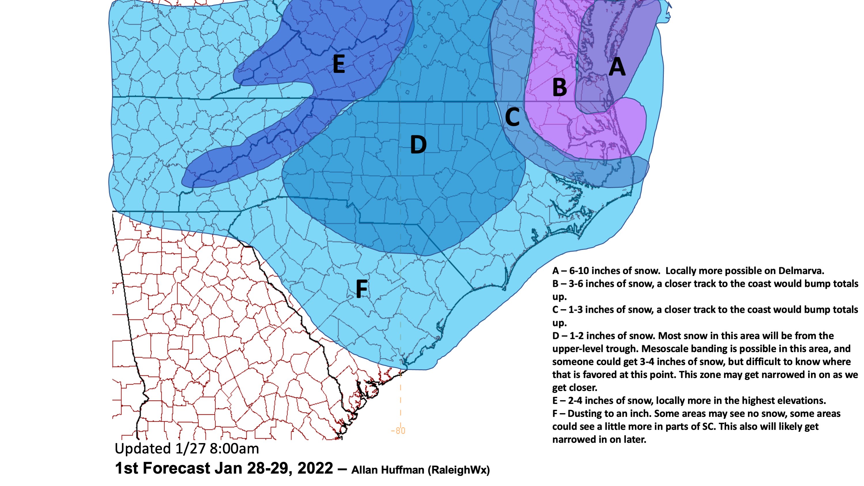
RaleighWX updated map


I really like Kershaw and Fairfield counties from what I’ve seen. It also may be a rare time that the panhandle of Lancaster does worse than southern.This is mainly for Southern areas outside CLT/Eastern NC etc:
Those old ARW/NSSL models are pretty darn good for stormy weather; but Winter they tend to run too cold. They haven't been upgraded and likely won't be again before full replacement by the new FV3 core versions. The NAM the same idea.. FV3 core taking over..
I like the idea that the RGEM has still.. it's really showing areas who are going to have lighter precipitation with warmer temperatures towards the surface.
With that said, the RGEM tends to run a bit cold also. I like the 3KM NAM for thermal soundings and if you look closely you will see pockets of "green" on the ptype maps over the central midlands that is trying to warn that the dynamics may just be just nothing.... but as you head into the Northern Midlands / CLT region the rates/dynamic cooling really takes affect.
This is a very tricky forecast for this area, and I don't envy the NWS tbh. 700mb argues deeper saturation and someone is going to get thumped by accident and it's dang near impossible to figure out who... common sense says Fairfield North -> East
more in NC than Boston from this system after it was shown to be bringing the feet.... man, the meltdown in the NE threads would be tasty!Heres what's taking the Nams Place soon: Only goes out to 60
I really like Kershaw and Fairfield counties from what I’ve seen. It also may be a rare time that the panhandle of Lancaster does worse than southern.
more in NC than Boston from this system after it was shown to be bringing the feet.... man, the meltdown in the NE threads would be tasty!

I agree. I think the next few runs of the Nam will be even better.oh come on guys. i really liked the nam and i think yall are being too pessimistic.
Two superb trends here- four corners shortwave keeps ticking east. I also love, love the subtle west shifts on the western edge of the longwave trough- it's ticking further west. think that favors a little more digging and helps with the tilt issue.
View attachment 110945
Thought the surface reflection was also remarkably reasonable. gun to my head somebody tells me "draw the precip shield of a sub 1000 lp 200 miles east of ILM" i probably draw something like this.

3km was a little iffier with cyclogenesis, it didn't have it building towards s florida- something to keep an eye on.
It’s been going back and forth quite a bit with this storm. I think the EURO has been the most consistent IMO12z RGEM looks much worse than the 6z run from what I can tell.
The maps on psu ewall are usually good at showing the meso low. Can see it here on the 06z GFS (top middle panel of images). It's not a Wham-Bam feature, but you can see the kink in the isobars where you can connect an inverted trough line from the meso low in the upstate to the sfc low off the coast. But there is some enhanced low level convergence associated with it (enhancing rising motion). As mentioned before, the precip will tend to form and expand in the lee of the Apps, then slowly move off to the east and southeast. Temperatures tomorrow aftn are likely to get up to 45-50, but the near sfc warm layer is tiny. Any meaningful precip should crash everything over to snow Fri evening/nightWhere do you find the lee side low forming, is that showing up still on the mesoscale models this morning? I can't find it.


What's it warning12z RGEM warning shots View attachment 110961
Charlotte gets skunked like the rest of usWhat's it warning

Well the sweet spot right over my house… what could go wrong?

man oh man. really good agreement now over clt.


Hate seeing such a "wack-a-mole" orientation of the precip around CLT on guidance. Such a small window. Euro I score, GFS I'm fringed. Who the heck knows at this point? RGEM verifies I get nothing.
I guess I'm rooting for a nice lee side low to form and have more solid precip blossom to my west to the apps like @griteater mentioned.
I will say…. The EURO has been very consistent with showing this now for the last few days and has had a ton of support from both the EPS and GEFSHate seeing such a "wack-a-mole" orientation of the precip around CLT on guidance. Such a small window. Euro I score, GFS I'm fringed. Who the heck knows at this point? RGEM verifies I get nothing.
I guess I'm rooting for a nice lee side low to form and have more solid precip blossom to my west to the apps like @griteater mentioned.
Going to be local winners and losers for sure with a splash of thunder. Euro/HRRR/ARW have the best precip shield back to the west/southwest at the moment.Hate seeing such a "wack-a-mole" orientation of the precip around CLT on guidance. Such a small window. Euro I score, GFS I'm fringed. Who the heck knows at this point? RGEM verifies I get nothing.
I guess I'm rooting for a nice lee side low to form and have more solid precip blossom to my west to the apps like @griteater mentioned.


Yea, and if I recall the snowfall map isn't typically updated till at least 7pm.When I sample the latest point forecasts for various locations in RAH’s area, they’re not matching this morning’s probabilistic snow map. Highest totals are now west and extreme northeast. Highly likely that the afternoon discussion and map update will reflect some changes.

