Stormsfury
Member
Been noticing that the Euro is consistently putting out higher totals than other models for the mountains along the NC/TN border. Does anyone know what’s causing that?
NW flow Snow
Been noticing that the Euro is consistently putting out higher totals than other models for the mountains along the NC/TN border. Does anyone know what’s causing that?


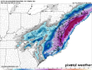
All Models are locked in the this band… not often you get so much agreement on a mesoscale band View attachment 110908View attachment 110909View attachment 110910
Latest rap has over 4 inches in spots in that band getting close to 5 lol, Charlotte gets that lucky pivotAlso, those bands are typically stronger than modeled .
Sent from my iPhone using Tapatalk


I’m still skeptical about that dry clot .. also we’re still 1-2 days away here there is room for changesCan see why the Euro wants nothing to do with the SLP precip extending west.
The very thing that is going to dump snow on CLT is killing RDU’s chance at coastal snow. ?
View attachment 110916
Best shot for snow at this point for most is going to be the pivoting ULL band. Luckily these things are usually more widespread with precip and have heavier returns within them. I think 2-4” is going to be a strong possibility from GSP to CLT to GSO and yes even down towards Columbia (especially the northern suburbs) as it stand a right now.


Yes I agree… that track is close enough to the coast that precip should be filling in that dry slot… I would watch the HRRR in coming runs to see if it fills it inI’m still skeptical about that dry clot .. also we’re still 1-2 days away here there is room for changes
If we can just not waste precip on initial rain we could really score here.
This is mighty depressing watching from Raleigh I need a shift East please ?
Thats definietly the case for your area. I sit right on the line of both and preferably for myself would feel more confident in the coastal winding up and staying tugged in tight than depending on some upper level energy getting lined up just right in a pivot. This would require the ULL to stack quicker along SC coast so its deepening as it rides in tight up the NC coast, Course , there is a way to score both ways. But west of 85 no doubt your rooting for pivoting ULL. I have pretty decent/ not perfect odds whichever way it plays out.Best shot for snow at this point for most is going to be the pivoting ULL band. Luckily these things are usually more widespread with precip and have heavier returns within them. I think 2-4” is going to be a strong possibility from GSP to CLT to GSO and yes even down towards Columbia (especially the northern suburbs) as it stand a right now.
What is the total accumulation? Trying to see what it’s showing In Columbia sc?
Your bulls eye will be fairfield county north per 06z euro with almost .5 qpfWhat is the total accumulation? Trying to see what it’s showing In Columbia sc?
This just isn’t something that would help Raleigh much, as this is more geared to helping the western Piedmont… CLT metro to the Triad and west. I still think if the surface low follows the track the Euro is showing, Raleigh will get in on more from that than what’s being depictedThis is mighty depressing watching from Raleigh I need a shift East please ?
Getting inch mean all the way down i26 in SC to Charleston. Wow I honestly think it’s possible with this setup.
Based on the soundings, it should be solidly snow even while the surface depicts rain… perhaps there’s a bit of drizzle very initially while the lowest levels become saturated, but as soon as the rates get beyond that the temperature crashes to freezing in a matter of minutesIf we can just not waste precip on initial rain we could really score here.
Yeah I’m not concerned about that aspect of the setup eitherBased on the soundings, it should be solidly snow even while the surface depicts rain… perhaps there’s a bit of drizzle very initially while the lowest levels become saturated, but as soon as the rates get beyond that the temperature crashes to freezing in a matter of minutes
Are we dealing with higher ratios down here like RAH was mentioning for the Raleigh area?Based on the soundings, it should be solidly snow even while the surface depicts rain… perhaps there’s a bit of drizzle very initially while the lowest levels become saturated, but as soon as the rates get beyond that the temperature crashes to freezing in a matter of minutes

That’s so difficult to say. I always lean on climo around here when it comes to ratios, because it’s so hard to get much above 10-12:1 here… I thought last week may be the exception but we still just managed 13:1.Are we dealing with higher ratios down here like RAH was mentioning for the Raleigh area?
Yeah I’m not concerned about that aspect of the setup either

Here's the 3K showing a nice evolution of the band associated with the upper trough. I hate relying on these things. They can be fickle and can also disappear like a fart in the wind. But if these trends remain steady today then WSW may be needed for the 85 corridor from CLT to the Triad. Best of luck to everyone.
By the way: TD now has precip maps for the EC.
View attachment 110927