RVD
Meteorology Student
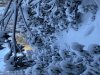
Scrolling through radar tilts from KRAX reveals a good amount about how well precipitation is reaching the ground in central NC. To be honest, this isn't too bad. A lot of these bands (especially to the SE) change only a little with height, which is a good sign (coupled with mPing reports in the last ~30 min) that these are reaching the surface. The bands further north are more virga, but as instability builds and our upper level trough approaches this afternoon, that almost certainly will not last.
Congrats to all who have seen flakes so far!

Congrats to all who have seen flakes so far!