Hilarious this is still moving around within 48ish hours


Notably the Euro is more west and stronger.Creeping closer to OBX
View attachment 174393

Tropical storm warnings for the OBX at 5pm?Notably the Euro is more west and stronger.
it's been pretty systematic. did weekend RI help pump the ridge stronger than guidance suggested?I don't think many people honestly thought this one had a shot to make it inside 75W. It may not make it but it'll get close it appears. This storm has scrapped and clawed it's way west it's entire existence. Pretty impressive.
View attachment 174394

Maybe? That and just those westward lurches it had a few times along with the synoptic adjustments have all worked in tandem to shift it a lot further west than what was modeled a week ago.it's been pretty systematic. did weekend RI help pump the ridge stronger than guidance suggested?


SheeshThe 12Z UKMET gets to only 115 miles SE of Cape Hatteras at hour 72, when it has it still down at 950 mb!View attachment 174401

Forget GFS....this is the one to watch as well as UK..Icon and UK aligned.A few more miles west
View attachment 174406


Probably sampling the upstream environment to help with the modeling I’d guess
Probably sampling the upstream environment to help with the modeling I’d guess

Imagine of this had stayed on that wnw heading another 12-18 hours!It just won't stop.View attachment 174412
Wonder if the west correction continues tonight.It just won't stop.View attachment 174412
Too many people saying "oh it's going to stay just offshore, we'll be fine" may be leading to some paying the price already. Apparently, you had a commercial airliner fly through the storm to boot as well. Made it through, but still, silly.
Too many people saying "oh it's going to stay just offshore, we'll be fine" may be leading to some paying the price already. Apparently, you had a commercial airliner fly through the storm to boot as well. Made it through, but still, silly.
Thats tonights 18Z?It just won't stop.View attachment 174412

Too many people saying "oh it's going to stay just offshore, we'll be fine" may be leading to some paying the price already. Apparently, you had a commercial airliner fly through the storm to boot as well. Made it through, but still, silly.

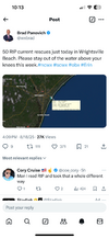
Never will understand why people ignore the red flag warnings and go into the ocean. The amount of rip current rescues today in NC is ridiculous.
Also, we're seeing once again how the models can change with the track all the way until we're inside 24 hours. Seems to happen almost everytime with tropical systems the last decade or so.