• Hello, please take a minute to check out our awesome content, contributed by the wonderful members of our community. We hope you'll add your own thoughts and opinions by making a free account!

Tropical Major Hurricane Erin

Will be interesting to see what she does with a new eye...if she bombs back out does she move more west again etc...if she makes it to 73/74 west things could get rough on the OBX.
That would put the OBX in the tropical wind field for certain. A little nudge further west and it would be experiencing hurricane winds gusts. Erin is going to be a big storm as far as size.
 
11 am NHC
The track guidance is in good
agreement on the northward turn but there are differences in how
close the hurricane will come to the U.S. east coast in the 72 hour
time frame. The new official forecast has been shifted a little to
the west at 3-4 days based on the model consensus. Some additional adjustments to the forecast are possible in future advisories.

It should be noted that the 34- and 50-kt wind speed probabilities beyond 36 hours in the text and graphical products are likely underestimating the risk of those winds occurring. This is because the forecast wind field of Erin is considerably larger than average compared to the wind field used to derive the wind speed probability product.
 
Is the GFS an euro really that far apart
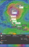
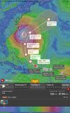
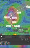
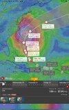
The first pic is Euro and the second is GFS. Last is Icon since it's the closest to land and still forecasting 915 pressure for the 4th day.

Answer to question....Yes, considering the risk.
Euro and ICON are aligned.

If they moved the cone so the center was aligned with Euro/ICON, then the cone would be over land. Can't have that since they pronounced the OTS message (sarcasm). What a travesty if it explodes again.

Screenshot_20250817-143109_Windy.jpg

Screenshot_20250817-143149_Windy.jpg

Screenshot_20250817-143351_Windy.jpg
 
Last edited:
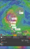
Just found out what this windy app can do. See NHC cone. See the Euro position in comparison to the cone, then see the Icon same.
I won't be surprised to see that cone continuing to move west.

View attachment 174348

View attachment 174349
The Windy app you are using is very interesting. You may have found them another subscriber after I checked out the features online.
 
Somewhat new to tracking the tropics. Does this temporary weakening of Erin make the turn less likely/slower? I know the stronger storms want to gain latitude. Just wondering if this weakening makes in harder for it to turn the corner and shoot the gap in the ridge. Thanks
 
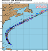
Yeah the NHC is gonna move the track inland with these models that have not changed. Like they aren't even that close. They aren't stupid and they have a very stellar forecasting history 99 percent of the time. They also have models we don't see

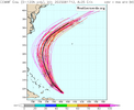
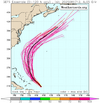
I have been telling people for days that there has never been one rogue model even show a landfall05L_tracks_latest (2).png
AL05_2025081712_ECENS_0-120h_large.png
AL05_2025081712_GEFS_0-120h_large.png
 
Last edited:
Yeah the NHC is gonna move the track inland with these models that have not changed. Like they aren't even that close. They aren't stupid and they have a very stellar forecasting history 99 percent of the time. They also have models we don't see

I have been telling people for days that there has never been one rogue model even show a landfallView attachment 174359
View attachment 174360
View attachment 174361
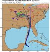
I don't think there is even a remote chance of a direct hit. Depending how close it gets, the flooding could be huge. I.e. Matthew 2016 and it was cat1. Very possible they will move it closer to shore. At least that's what they said in the last discussion.

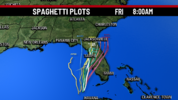
But this first one below in pic was 2 days prior to 2024 landfall.....we all know it went east.
The second one is the day before 2022 landfall. We know it hit Ft. Myers instead of Tampa.

So not a fan of taking average of averages, which is what they do.
It takes the thought and responsibility off them.

479511979_1173803520769650_111451262526885664_n.jpg

Spaghetti-Plots.png
 
Last edited:
5pm

The track guidance is basically unchanged from earlier today, so the new official forecast is essentially an update of the previous one.
This remains close to the dynamical model consensus TVCN and is is also similar to the latest FSU Superensemble guidance.

Erin exhibited an eyewall replacement earlier today, with the eye
diameter increasing from 5-10 n mi to around 40 n mi. If the
replacement cycle completes, there should be a contraction of the
eyewall by tonight. This would likely result in another
intensification episode.

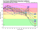
TVCN is an average of an average. That's got them in trouble more than once.

05L_intensity_latest (5).png
 
Last edited:
Somewhat new to tracking the tropics. Does this temporary weakening of Erin make the turn less likely/slower? I know the stronger storms want to gain latitude. Just wondering if this weakening makes in harder for it to turn the corner and shoot the gap in the ridge. Thanks
Unlikely that it will miss the escape route. But coast of NC could feel tropical storm effects or even hurricane winds from the outer bands.
 
"The National Weather Service said coastal and beach flooding from Hurricane Erin is a “significant threat to life and property.” Flooding of “many” homes and businesses is likely and numerous roads will be impassible, forecasters said."

The National Weather Service in Morehead City said the coastal flood watch is in effect from Tuesday afternoon through Thursday night in Carteret, Onslow counties, the northern Outer Banks, Ocracoke Island and Hatteras Island.

A high surf advisory is active from noon Tuesday to 8 a.m. Friday for the same areas at the North Carolina coast, the weather service said.

A Mandatory Evacuation has been issued for Hatteras Island (Zone A) as follows. (Zone A includes all of Hatteras Island, including the unincorporated villages of Rodanthe, Waves, Salvo, Avon, Buxton, Frisco, and Hatteras.)

 
0Z UKMET: furthest NW and strongest run yet while SE of NC at closest point (942 mb!). It is then a mere 135 miles SE of Hatteras as of 8AM Thu!

HURRICANE ERIN ANALYSED POSITION : 22.0N 68.9W

ATCF IDENTIFIER : AL052025

LEAD CENTRAL MAXIMUM WIND
VERIFYING TIME TIME POSITION PRESSURE (MB) SPEED (KNOTS)
-------------- ---- -------- ------------- -------------
0000UTC 18.08.2025 0 22.0N 68.9W 938 101
1200UTC 18.08.2025 12 23.0N 70.7W 949 96
0000UTC 19.08.2025 24 23.9N 72.0W 968 69
1200UTC 19.08.2025 36 25.3N 72.8W 969 71
0000UTC 20.08.2025 48 27.2N 73.8W 964 60
1200UTC 20.08.2025 60 29.2N 74.3W 957 81
0000UTC 21.08.2025 72 31.6N 74.8W 949 91
1200UTC 21.08.2025 84 33.6N 73.8W 942 82
0000UTC 22.08.2025 96 35.4N 71.9W 943 69
1200UTC 22.08.2025 108 36.1N 69.7W 942 70
0000UTC 23.08.2025 120 36.9N 67.7W 947 63
1200UTC 23.08.2025 132 37.9N 66.1W 951 66
0000UTC 24.08.2025 144 39.3N 64.3W 955 58
1200UTC 24.08.2025 156 40.9N 62.4W 956 55
0000UTC 25.08.2025 168 42.8N 58.8W 964 52

@Henry2326 because you’ve been warning us about the danger to NC especially
 
^Followup to text: Here’s the 0Z UKMET 84 hour map at closest approach to NC:

View attachment 174380
This is exactly what I've been screaming about.
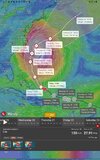
The 1st pic below is Icon compared to UK. The spinning storm is Icon, while the cone is UK. Fully aligned. Appears to me, thst the UK thinks it won't make as sharp a turn, placing it closer to land, which IMO higher risk of flooding.

The 2nd pic is Icon spinning storm (UK also as we just saw in pic 1) compared to NHC cone.

The 3rd pic is Icon spinning storm with Euro cone, which is consistent with GFS although not showing.
There is a risk of it being closer to land than shown in NHC cone.
Screenshot_20250818-062247_Windy.jpg

Screenshot_20250818-062425_Windy.jpg

Screenshot_20250818-062445_Windy.jpg
 
Last edited:
905 mb on the Euro!!! 😳 That would be stronger than Saturday mornings peak was

Recon already reporting mid 930sView attachment 174386

The ICON is showing similar numbers as far as intensity. To be honest, the ICON has done a better job of tracking Erin than the GFS and Euro. It has been more consistent in showing a more westerly track and a closer approach to the East Coast.
 
Based purely on forward motion...

When Erin's typical forward motion was West, the wobbles caused a S motion. As the storm pivots so the forward motion is generally North, do the wobbles still go to the left of forward motion and does this mean enough wobble could be even more problematic - wobbling west?
 
Back
Top