Shaggy
Member
Yeah I agree. I could see 896-904 as a good bottom range.I don’t think it challenges Wilma, but dang looking at the still cooling cloud tops, sub-900mb is possible.
Yeah I agree. I could see 896-904 as a good bottom range.I don’t think it challenges Wilma, but dang looking at the still cooling cloud tops, sub-900mb is possible.
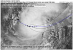
This motion about kills any chance of significant land interaction. And, it looks like the forward motion is picking up the pace too.It looks like on the last few frames of the satellite that the storm has lost all southerly component to its forward motion and might be starting to go just barely north of due east. Also I’m curious what the wave heights are right now near the northwest Yucatán coast… that’s an area that typically is already fairly rough
You’re right. With the small core and small eye, it was going to have to get extremely close if not make a landfall to have any real effect on the storm.This motion about kills any chance of significant land interaction. And, it looks like the forward motion is picking up the pace too.
Can’t a mega strong storm like this, actually “ bounce” of of land like the Yucatán?? Maybe its strength saved its small demise?? I think this is a thing??It looks like on the last few frames of the satellite that the storm has lost all southerly component to its forward motion and might be starting to go just barely north of due east. Also I’m curious what the wave heights are right now near the northwest Yucatán coast… that’s an area that typically is already fairly rough
This motion about kills any chance of significant land interaction. And, it looks like the forward motion is picking up the pace too.
Just saw Webb mentioned on Twitter that MPI may not fully account for the conveniently placed jet streak tomorrow which may allow Milton to strengthen past the calculated values in the GOMTheoretical max potential energy. Someone somewhere on Twitter has a map showing GOM supporting 900mb intensity but nothing less than that. But with the way pressure continues to drop like a rock we’ll see if that’s true
yeah- radar, satellite, recon data all confirm this. turn happened quicker than expected from NHC forecastIt looks like on the last few frames of the satellite that the storm has lost all southerly component to its forward motion and might be starting to go just barely north of due east. Also I’m curious what the wave heights are right now near the northwest Yucatán coast… that’s an area that typically is already fairly rough

Storms usually seem to attempt to avoid landfall in the absence of defined steering. That said, I've seen more than a few hurricanes get pulled into the coast when a landmass is to the south. I was sort of hoping this may occur with Milton but the recent motion and small core makes this extremely unlikely.Can’t a mega strong storm like this, actually “ bounce” of of land like the Yucatán?? Maybe its strength saved its small demise?? I think this is a thing??
I’m not sure if it is or not. I’ve notice a few times storms that are riding close to the southern coast of Cuba tend to bounce around little and take some weird jogs. Of course that a much different land than the Yucatan. Cuba has some tall mountains and the Yucatán is flatCan’t a mega strong storm like this, actually “ bounce” of of land like the Yucatán?? Maybe its strength saved its small demise?? I think this is a thing??
Obviously we’re used to seeing stronger storms moving west tend to move more along the northern side of the track. Would that still be the case with a storm moving east?yeah- radar, satellite, recon data all confirm this. turn happened quicker than expected from NHC forecast
View attachment 152808
be wary using the eye on this graphic as the true center due to parallax, but you get the idea.
will need a few more hours of movement to determine whether this is just an illusion from a troichoidal wobble or a systematic deviation from NHC/model consensus stemming from a more intense storm than guidance prognosticated. something to keep an eye on!
You should. Most likely it will hit as a cat3.Thought about chasing this one but not sure yet
Hurricane Lenny in 1999When was the last time a storm traveled this far west to east ?? I can't remember any.
I think I saw one on the way on TT before it went down… someone correct me if I’m wrong thoughAnyone know when the next plane is going in? TropicalTidbits is down
That's the upper-level plane. The lower-level plane is expected to leave about 10 minutes and arrive around 5:30 PM.I think I saw one on the way on TT before it went down… someone correct me if I’m wrong though
I think so but I'll mention a lot of my internal climatology maxims like the above are scrambled. Steering currents in the upper levels definitely favor more northward movement though, may be thatObviously we’re used to seeing stronger storms moving west tend to move more along the northern side of the track. Would that still be the case with a storm moving east?

Storm surge kills. Unless he has multiple escape routes or plans to stay well away from surge zones, no.You should. Most likely it will hit as a cat3.
Well that’s pretty much your worst-case scenario right there
The fact wilma was 882 with a 2 mile wide eye. I think he gets down to 900-905 easily but reistically speaking sub 900 is almost unheard let alone sub 890
One thing I’m a little encouraged by is that the hurricane models show it weakning as it goes in around Tampa. If you recall, they absolutely nailed the intensity of Helene.
Well 2.3 to.be exact. This may be the 2nd smallest eye i can recall2 mile eye? That's basically a large tornado.
Sent from my iPhone using Tapatalk
Wont matter....Cat 5 storm surge will have already built up.One thing I’m a little encouraged by is that the hurricane models show it weakning as it goes in around Tampa. If you recall, they absolutely nailed the intensity of Helene.
That’s trueWont matter....Cat 5 storm surge will have already built up.
| 4:00 PM CDT Mon Oct 7 Location: 21.8°N 90.8°W Moving: E at 10 mph Min pressure: 905 mb Max sustained: 180 mph |
