924Mb XTRP!

924Mb XTRP!
View attachment 152784


Is that two uncontaminated 175knt SRMF I see!?
Yep. 200 mph roughly.Is that two uncontaminated 175knt SRMF I see!?
it does make a difference and every hurricane model we use (hwrf, hmon, hafs(s)) uses the gfs as the parent environment. if the gfs is this off the mark at initialization then this model suite may be cooked as the kids sayI'm not sure if it will make a difference, but 12z GFS has a noon Monday starting position of 982. This run may be trash....
Heck, all the 12z models may be cooked.....flying blind.....but adding my public service announcement.it does make a difference and every hurricane model we use (hwrf, hmon, hafs(s)) uses the gfs as the parent environment. if the gfs is this off the mark at initialization then this model suite may be cooked as the kids say
i was going to post something a few hours ago like lol this might be sub 920 by lunch but deleted it because it was too hyperbolic. little did i know....
the recon plane just took on a 2k foot drop. one of those passes the crew will have stories about
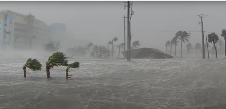
this entire thing feels like a fever dream. this is the manifestation of one of those cheap "bad storm" documentaries the weather channel produced in the late 2000s as an innings killer when there was nothing interesting going on
i felt pretty sure this would weaken enough pre landfall to avoid the upper echelon emergency solutions but now i'm no so sure about that
Yep. 200 mph roughly.
.. with higher gusts.

Dang that is 175-180mph at the surface if my calculations are right.
This run is trash. It starts out with 982 pressure for current and we are at 925. But still a nightmare.....Oh my god. This is the stuff nightmares are made of for Tampa
It's not currently displaying ship data.I'm thinking of ships at sea closest to Milton. Is there a place online people go to check their weather instruments reporting?

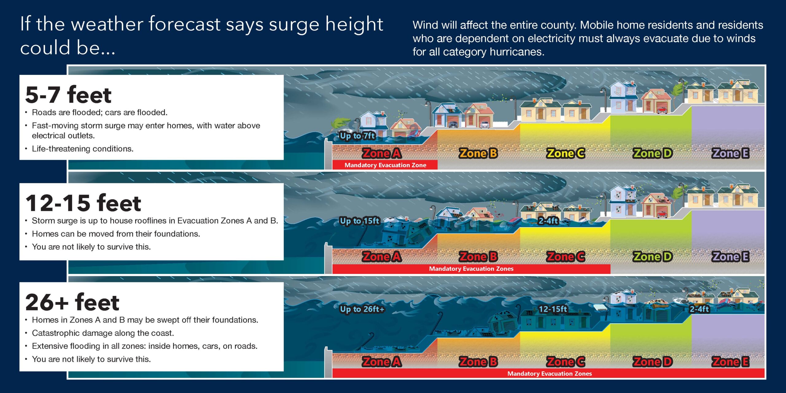
Anyone know what the SLOSH model prediction is for the Tampa area? If they even use this model still.

Those 175 kt readings were surface level. 200 mph at the surface. Not official.
That 160mph looks really conservative. I think we have a 170mph-180mph hurricane currently. I kept my lips tight with everyone expecting this thing to lose steam and weaken as it approaches land. These things have routinely been stronger than anticipated and for longer the last 10 years. Even Helene was well on her way to a strong Cat 5 all the way to landfall if not for her forward speed increasing as fast as it did. And while it may weaken still as it approaches land, the starting point of that has quickly gone from a peak of around 930-940mb and a Category 4 to likely around a sub 910mb and over 180mph Cat 5. This thing has a real shot to make landfall as a Cat 5 even with some weakening. Note though with this thing being as strong it's going to be able to fight off shear (personally based on the track I think it was going to be minimum anyway) and dry air for a lot longer.
charley went well south of Tampa correct ?Seems like this could be setting up as a “worst case” scenario for Tampa Bay. Of course, we’ve thought that was going to happen before (i.e. Charlie 2004) and it’s avoided a direct hit and mostly spared them the worst destruction, but things aren’t looking good as of now.
Isn’t it hitting ever so slightly north of Tampa the worst case scenario because they’d get the worst of the winds coming in from the south and west and pushing water into the bay?I think they moved it a smig north. My opinion, they will keep doing that. It will come in just north of Tampa, but the damage to Tampa will be devastating without a headon.
Correct. It made landfall around Punta Gorda. I think the wind field in that one may have also been small, though I’m going off memory there and may be wrong.charley went well south of Tampa correct ?
It came in near Punta Gorda, and had a very small wind field. It was on a b-line for Tampa but took an easterly jog at the last minutecharley went well south of Tampa correct ?
charley went well south of Tampa correct ?
 pinellas.gov

The CDO is much more symmetrical now and really only needs slight improvement in the SSE quadrant. Excellent outflow across the board. It wouldn't surprise me for it to make it to 180 before weakening. Motion still looks ever so slightly south of due east.Peak atlantic hurricane right hereView attachment 152794

