Belle Lechat
Member
- Joined
- Aug 29, 2021
- Messages
- 1,547
- Reaction score
- 1,224
Can you see landfall for th is version?
Not very close. Not one model has it hitting land.South of due east movement still, will be interesting to see how close to Yucatan it gets.

"Wilma's rapid intensification led to a 24-hour pressure drop of 97 mbar (2.9 inHg), setting a new basin record."This is what Wilma was like
Clearly the gulf is handing us unprecedented scenarios.....I expect that to continue.
I disagree there, 2005 still takes to cake no doubt.

Yeah 2005 was really something Katrina would end up being the 3rd strongest storm that year
Wilma was so shocking to the NHC they did another recon pass

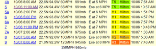
So roughly 22 mb in a couple hours
Thursday amCan you see landfall for th is version?
We have all hurricane models, GFS, and Euro for landfall Thursday.

So roughly 22 mb in a couple hours

Cat4 to Cat5So are we looking at roughly a CAT 3 hitting the Tampa area?
Thanks, I have not been able to follow much over the weekend.Cat4 to Cat5
This is what I'm thinking also. The erc will only expand the wind field when that happens.Cat4 to Cat5
It's probably going to max out now that it wrapped more convection around the N side and really got symmetrical
Don’t we mean Sarasota/Bradenton? Did something change from NHC?Cat4 to Cat5

.png")
.png")