NBAcentel
Member
gefs is pretty similar to the EPS runs from yesterday with some bigger ice storms in CAD regions, but also some R/S solutions. Interesting run. Definitely more of a western Atlantic ridge response


agreed this is a few nudges away from a m o n s t e r75 miles SE and this is a server melterView attachment 141519

Cant look back at the moment. How did this compared to the 12z?
This was a 15:1 ratio or kuchera?
10:1 ratioThis was a 15:1 ratio or kuchera?
And plenty of time for that to happen.75 miles SE and this is a server melterView attachment 141519
Was trying to figure out the upper end part. Lol10:1 ratio
oh okay, yea 90th percentileWas trying to figure out the upper end part. Lol
I just don't see the cold air for a winter storm reaching the Piedmont and coastal areas in time. This screams a Mtn/foothills event and even here in the foothills accumulation is not a given. Need to see where things stand Sunday to hone in on accumulation.I could be wrong and hope I am, but I bet this is about as good as it’s gonna get.
It hasn't ran quite yetWhos got 18z euro control? Or does it only run at 6z? TIA
7pm and eps after 8pm.Whos got 18z euro control? Or does it only run at 6z? TIA
You mean the GFS products were too progressive? LMAOwas going to comment something like this. gfs ens run is pretty interesting- definitely some changes
bigger SER, sharper trough, and in response.. check out how qpf lurches inland
View attachment 141514
i will say this. if this trend continues after me moaning about it all day. this i will take the L and yall will have full right to be mad at me haha
It would be cool to have an analog snowfall map like this based on a mega-ensemble of all models, rather than it just being based off the GFSCIPS snow map
View attachment 141492
Couldn’t really say right now. If we dig the feature in the NE more and amp something back out west up, then it’s definitely possible@Myfrotho704_ What is your opinion about a potential ice threat from this?
It's a big blocking ridge over Greenland, yes, but regardless, it still comes down to what is going on up under the block...i.e. what is the size / location / configuration of the 50/50 low and how that relates to the height pattern and incoming waves over the CONUSI'm confused with how the UK is giving us an inland solution. I thought a cutter, amped or not, was pretty much off the table because of the massive block that will be in place and the LP that will be in front of the system in the NE. I guess maybe the UKMET is placing the LP too far North to prevent the storm from cutting.

Euro looks like it would be better. The S/W that screws up the strength of the western ridge is weaker this run


For who? NC/VA/TN or board wide (including central/eastern Georgia and midstate SC)?agreed this is a few nudges away from a m o n s t e r
Not the poster you responded to but it would just be a matter of how far S did it get and when could it potentially flip negative. It could potentially include any of the locations you mentioned aboveFor who? NC/VA/TN or board wide (including central/eastern Georgia and midstate SC)?

seems more reasonable but hey who knows...ill take it18z eps backed off from 12z. Looks a little more suppressive.


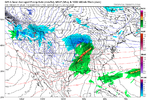
 Just some perspective on this storm coming up. This is the GFS at 120hrs out from the current storm in the northern plains, compared to 18hrs out. I’m not saying we will see things change in the same way, but they will almost certainly change