13L LEE 230909 0000 19.0N 56.0W ATL 105 958
-
Hello, please take a minute to check out our awesome content, contributed by the wonderful members of our community. We hope you'll add your own thoughts and opinions by making a free account!
You are using an out of date browser. It may not display this or other websites correctly.
You should upgrade or use an alternative browser.
You should upgrade or use an alternative browser.
Tropical Hurricane Lee
- Thread starter RBR71
- Start date
Brent
Member
This has to be one of the fastest drops I've ever seen over water from 165 this morning
Data from Air Force Reserve and NOAA Hurricane Hunter aircraft
indicate that maximum sustained winds have decreased to near 115
mph (185 km/h) with higher gusts
Data from Air Force Reserve and NOAA Hurricane Hunter aircraft
indicate that maximum sustained winds have decreased to near 115
mph (185 km/h) with higher gusts
Downeastnc
Member
This has to be one of the fastest drops I've ever seen over water from 165 this morning
Data from Air Force Reserve and NOAA Hurricane Hunter aircraft
indicate that maximum sustained winds have decreased to near 115
mph (185 km/h) with higher gusts
Reverseification....I wonder what the fastest or largest range for a non landfalling storm is.
Reverseification....I wonder what the fastest or largest range for a non landfalling storm is.
I’m going with Hurricane Lili. I think it went from a Cat 4 to Cat 1 just before landfall. That collapse was absolutely epic.
Hurricane Florence dropped from a category 4 to a 1 in about 48 hours if I remember correctly.I’m going with Hurricane Lili. I think it went from a Cat 4 to Cat 1 just before landfall. That collapse was absolutely epic.
Brent
Member
I’m going with Hurricane Lili. I think it went from a Cat 4 to Cat 1 just before landfall. That collapse was absolutely epic.
Ah yes I remember that one as a kid. It was literally within a few hours ?
Intensity wise, Lee has been a roller coaster ride. I don't believe I've ever seen a storm go from Cat 1 to Cat 5 in one day and then from a Cat 5 back to a Cat 2 the next day without a landfall.
Snow_chaser
Member
Lee looking rough, this keep up there won’t anything left of it to make a turn at 70°
HurricaneFred
Member
Reverseification....I wonder what the fastest or largest range for a non landfalling storm is.
JOAQUIN 2015??
Dry air is eating Lee up. You can see the damage to the the inner core on IR when hot towers erupt then dissipate and the erupt again. I’d bet that is a rough ride for HH turbulence wise. I saw this morning they had to go around the eyewall at one point.
HurricaneFred
Member
Lee completes a world's first time ever
A world first, every tropical ocean saw a Category 5 storm in 2023
https://www.yahoo.com/lifestyle/wor...tjuTrMSQfTPcz682iI-yOgL8c8ESPxHA-mmR_Q14S1o-N
A world first, every tropical ocean saw a Category 5 storm in 2023
https://www.yahoo.com/lifestyle/wor...tjuTrMSQfTPcz682iI-yOgL8c8ESPxHA-mmR_Q14S1o-N
Shaggy
Member
Euro now has a big hit on the NE
lexxnchloe
Member
It went way west.Euro now has a big hit on the NE
HurricaneFred
Member
what causes this big shift west?It went way west.
lexxnchloe
Member
High to its NE appears stronger and this euro run brings the pressure back down to 913 mbwhat causes this big shift west?
lexxnchloe
Member
910 mb
Brent
Member
Very little support for a US hit so far on the ensembles 
lexxnchloe
Member
12z today

last night

last night
First trough entices the north movement but it's faster and weaker so the system stays NW to N vs any east movement. The 2nd trough across the US is deeper the Atlantic ridge responds and the system accelerates NNW into the NEwhat causes this big shift west?
lexxnchloe
Member
Moving very fast as well. Of course it may be 600 miles east tonight

Aren't you at a football game? ??First trough entices the north movement but it's faster and weaker so the system stays NW to N vs any east movement. The 2nd trough across the US is deeper the Atlantic ridge responds and the system accelerates NNW into the NE
lexxnchloe
Member
Euro gets it back down to 910mb so that may be changing things as well
BHS1975
Member
Aren't you at a football game?

Weather nerd lol
Sent from my iPhone using Tapatalk
Leaving that hell hole nowAren't you at a football game? ??
Something to note… with the weaker system we have now and not really forecasted a couple days, it’s more possible for the storm to go further west initially and stay further south were doesn’t get pulled completely away by the trough. That looks like what the 12z EURO did.
Shaggy
Member
He seems to be on the rebound tonight
ForsythSnow
Moderator
This thing's practically moving W per recon. Not sure if it's a wobble or it really is drifting more and more west than expected. Going to be interesting to watch but I'm wondering if the weakness is going to keep it from going poleward as fast as expected, hence the runs with a NE hit on some modeling.
Snow_chaser
Member
Be something if it stayed weak and went far enough west, then strengthens and then makes a US hitThis thing's practically moving W per recon. Not sure if it's a wobble or it really is drifting more and more west than expected. Going to be interesting to watch but I'm wondering if the weakness is going to keep it from going poleward as fast as expected, hence the runs with a NE hit on some modeling.
Shaggy
Member
18z gefs had a strike on NC for the first time in a long time too, albeit just one memberThis thing's practically moving W per recon. Not sure if it's a wobble or it really is drifting more and more west than expected. Going to be interesting to watch but I'm wondering if the weakness is going to keep it from going poleward as fast as expected, hence the runs with a NE hit on some modeling.
Looks like that 12z euro run yesterday was a one off, 0z back east and a recurve. Every model turns hard N then NNE, looks like SE Canada, Bermuda only land threats.
lexxnchloe
Member
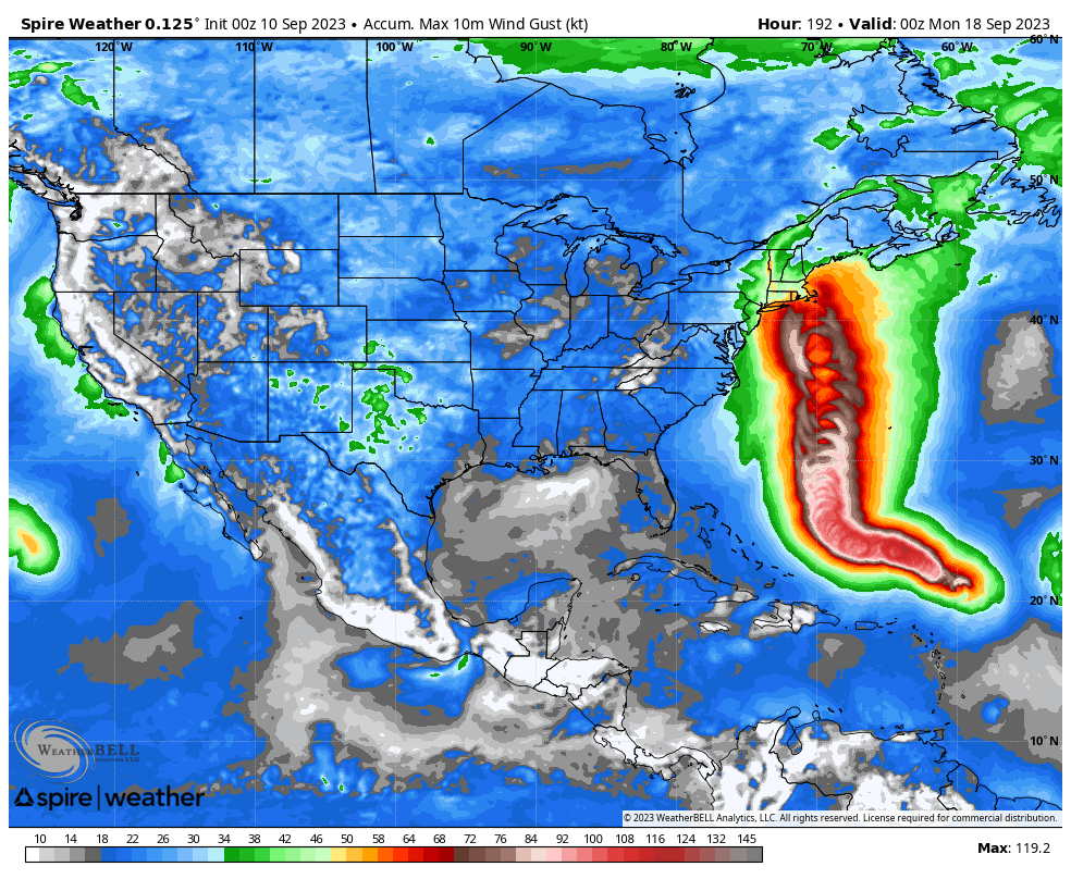
Spire model says a southern New England hit will happen

Shaggy
Member
Still enough uncertainty for those up in the NE
lexxnchloe
Member
Spire, gfs and icon all went west. Will the euro go back west?
NoSnowATL
Member
Cape Cod to Maine looks to be the hot spot. Glad to see the SE out of the path.
NoSnowATL
Member

Brent
Member
Definitely more members hitting New England now. The slower trend definitely is increasing the threat
So more and more it's looking like Lee will visit New England....anyone have a general time frame? I don't mind the rain, it's the winds that knock us around up here!!! Fingers crossed it fishes out!