That would be a very strong cold front that comes through with that temperature gradient, especially for the summer months. I could only imagine the severe weather that might occur with it.View attachment 136222
Obviously off its rocker but imagine going from all time high temps to fall in three days
-
Hello, please take a minute to check out our awesome content, contributed by the wonderful members of our community. We hope you'll add your own thoughts and opinions by making a free account!
You are using an out of date browser. It may not display this or other websites correctly.
You should upgrade or use an alternative browser.
You should upgrade or use an alternative browser.
Pattern August 2023 Thread
- Thread starter SD
- Start date
BHS1975
Member
View attachment 136222
Obviously off its rocker but imagine going from all time high temps to fall in three days
That's how we roll these days.
Sent from my iPhone using Tapatalk
At least it gives some hope that we’re getting closer to days like thatView attachment 136222
Obviously off its rocker but imagine going from all time high temps to fall in three days
- Joined
- Jan 23, 2021
- Messages
- 4,603
- Reaction score
- 15,199
- Location
- Lebanon Township, Durham County NC
I can remember I was in Columbia, SC during the 2012 heat wave and that was broken by one of the most hellacious storms I’ve ever seen.That would be a very strong cold front that comes through with that temperature gradient, especially for the summer months. I could only imagine the severe weather that might occur with it.
Here we go again.


Tomorrow looks much better than today ever did. I honestly didn’t know what they seeing to move that slight risk into NC today…the front looks like it’s coming in with almost perfect timing tomorrow to really fire things up I-77 corridor and east
Suck factor high. Can’t think of anything more oppressive in CLT. 12:30am 

Sent from my iPhone using Tapatalk


Sent from my iPhone using Tapatalk
Brent
Member
It is August 15th in 20 minutes and I have the windows open...
Wow, I saw Portland, OR hit 108 today! Would break RDU’s all-time high by three degrees, though at least it isn’t as humid there!
Drizzle Snizzle
Member
their 108 probably felt better than a typical 95 degree day in the southeast.Wow, I saw Portland, OR hit 108 today! Would break RDU’s all-time high by three degrees, though at least it isn’t as humid there!
BHS1975
Member
Steamy

Sent from my iPhone using Tapatalk

Sent from my iPhone using Tapatalk
LickWx
Member
Damn and that’s person county!View attachment 136222
Obviously off its rocker but imagine going from all time high temps to fall in three days
Brent
Member
.png")
Shaggy
Member
Brunswick County Airport to my south a bit never went below a 93 degree HI overnight and Wikmington international to my north just a bit only got down to 87 HI overnight.Steamy
Sent from my iPhone using Tapatalk
Both were already triple digit this morning
- Joined
- Jan 23, 2021
- Messages
- 4,603
- Reaction score
- 15,199
- Location
- Lebanon Township, Durham County NC


Tomorrow looks much better than today ever did. I honestly didn’t know what they seeing to move that slight risk into NC today…the front looks like it’s coming in with almost perfect timing tomorrow to really fire things up I-77 corridor and east
But it's things like this that make people not take the real threats seriously. The SPC has been awful lately with their categorical outlooks.
They did well with their Enhanced outlook the other day.But it's things like this that make people not take the real threats seriously. The SPC has been awful lately with their categorical outlooks.

Wish I was home right now.
Downeastnc
Member
I mean WTF.....been awhile since I have seen a heat index this high at PGV
This location out on the bombing range in the tidal swamps of Dare county is at 133 heat index with a DP at almost 90
Air Temperature
94°F
Winds (at 6m)
9 mph
From the south southwest
Gusts to 21 mph
Dew Point:
89.6°F
Relative Humidity:
87%
Heat Index:
133°F
 products.climate.ncsu.edu
| 15 | 12:05 | SW 10 | 10.00 | Partly Cloudy | SCT029 | 95 | 82 | 67% | NA | 120 | 29.86 | NA |
This location out on the bombing range in the tidal swamps of Dare county is at 133 heat index with a DP at almost 90
Air Temperature
94°F
Winds (at 6m)
9 mph
From the south southwest
Gusts to 21 mph
Dew Point:
89.6°F
Relative Humidity:
87%
Heat Index:
133°F
Station Scout – Products | North Carolina State Climate Office
products.climate.ncsu.edu
95/82 HI 120
Now we’re talking…

- Joined
- Jan 23, 2021
- Messages
- 4,603
- Reaction score
- 15,199
- Location
- Lebanon Township, Durham County NC
didnt realize wake was upgraded to an excessive heat warning
Shaggy
Member
A severe thunderstorm watch is out now until 9:00 tonight.

SEVERE THUNDERSTORM WATCH OUTLINE UPDATE FOR WS 649
NWS STORM PREDICTION CENTER NORMAN OK
150 PM EDT TUE AUG 15 2023
SEVERE THUNDERSTORM WATCH 649 IS IN EFFECT UNTIL 900 PM EDT
FOR THE FOLLOWING LOCATIONS
NCC001-003-007-025-033-035-037-045-051-057-059-063-065-067-069-
071-077-081-083-085-093-097-101-105-109-119-123-125-127-135-145-
151-153-157-159-163-165-167-169-179-181-183-185-191-195-197-
160100-
/O.NEW.KWNS.SV.A.0649.230815T1750Z-230816T0100Z/
NC
. NORTH CAROLINA COUNTIES INCLUDED ARE
ALAMANCE ALEXANDER ANSON
CABARRUS CASWELL CATAWBA
CHATHAM CLEVELAND CUMBERLAND
DAVIDSON DAVIE DURHAM
EDGECOMBE FORSYTH FRANKLIN
GASTON GRANVILLE GUILFORD
HALIFAX HARNETT HOKE
IREDELL JOHNSTON LEE
LINCOLN MECKLENBURG MONTGOMERY
MOORE NASH ORANGE
PERSON RANDOLPH RICHMOND
ROCKINGHAM ROWAN SAMPSON
SCOTLAND STANLY STOKES
UNION VANCE WAKE
WARREN WAYNE WILSON
YADKIN
Severe Thunderstorm Warning
NCC063-135-145-151830-
/O.NEW.KRAH.SV.W.0167.230815T1745Z-230815T1830Z/
BULLETIN - IMMEDIATE BROADCAST REQUESTED
Severe Thunderstorm Warning
National Weather Service Raleigh NC
145 PM EDT Tue Aug 15 2023
The National Weather Service in Raleigh has issued a
* Severe Thunderstorm Warning for...
Person County in central North Carolina...
Northern Orange County in central North Carolina...
Northwestern Durham County in central North Carolina...
* Until 230 PM EDT.
* At 144 PM EDT, a severe thunderstorm was located near Prospect
Hill, moving northeast at 35 mph.
HAZARD...60 mph wind gusts and half dollar size hail.
SOURCE...Radar indicated.
IMPACT...Hail damage to vehicles is expected. Expect wind damage
to roofs, siding, and trees.
* Locations impacted include...
Roxboro, Hillsborough, Rougemont, Carr, Bushy Fork, Lake Michie,
Moriah, Surl, Bahama and Schley.
Maybe today will be more active after all.
Downeastnc
Member
Just a tad bit of surface cape

Microbursts going to be common, atmosphere is explosive....


Microbursts going to be common, atmosphere is explosive....
Although the storm coverage will not be as expansive as last Tuesday, the parameters are there for some very strong storms to develop. This is starting to look more like what happened a week ago except that the brunt of the action will be further east towards the central parts of NC and Virginia. There will be more significant rainfall totals with these storms, especially in areas where training occurs.
Last edited:
Downeastnc
Member
Although the storm coverage will not be as expansive as last Tuesday, the parameters are there for some very strong storms to develop. This is starting to look more like what happened a week ago except that the brunt of the action will be further east towards the central parts of NC and Virginia.
There will be plenty of big wind in these storms....especially the ones that happen over the next 3-6 hrs during peak heating.....
BHS1975
Member
HRRR has been garb lately.
Sent from my iPhone using Tapatalk
Sent from my iPhone using Tapatalk
Been thundering here for the last 20 minutes. No rain, wind, or lightning.
Got a good size storm blowing up here at GSO. Should be down to you RDU guys in an hour or two
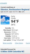
Good Lord. The 85 DP is higher than I’ve been able to find anywhere else. 97 / 85, 129 HI. ?

We had a couple of pretty strong cells pass through Athens a little while ago. I lost power twice as a result. The rain was voluminous.
Downeastnc
Member
Good Lord. The 85 DP is higher than I’ve been able to find anywhere else. 97 / 85, 129 HI. ?
View attachment 136238
Yeah this is pretty remarkable and luckily days like this are rare.
Guarantee there has been lightningBeen thundering here for the last 20 minutes. No rain, wind, or lightning.
Somehow the storms have missed me so far to the north, south, and even east.
Not any visual from my house. Thunder was from the storms going to my north and even materializing to the east of here.Guarantee there has been lightning