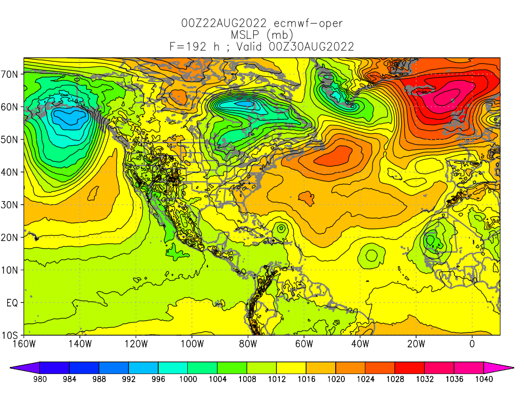
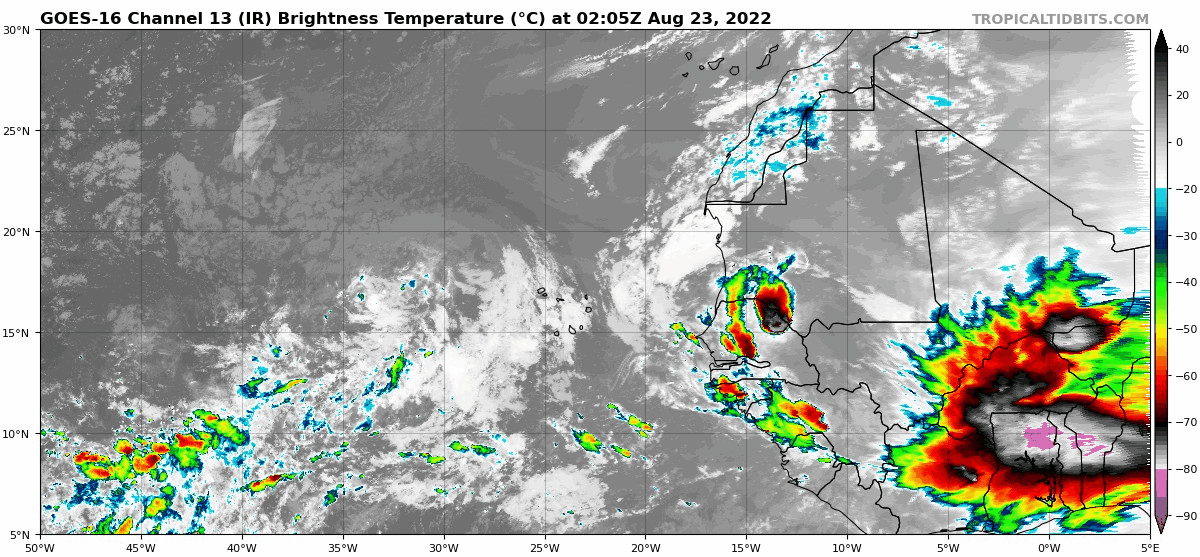
• Hello, please take a minute to check out our awesome content, contributed by the wonderful members of our community. We hope you'll add your own thoughts and opinions by making a free account!

Tropical 2022 Atlantic Hurricane Season thread

Invest 90L has been classified at 16.2N/29.3W. Last night’s EURO run showed it north of the Dominican Republic in 192 hours and strengthening. GFS ensembles and operational runs have supported the same scenario.


104-E3-B2-F-2708-4519-BD52-B6581-D22746-D.png
 
The HMON and HWRF runs on Invest 90L showed better short term organization for the tropical activity along the ITCZ from 60W to 40W so lets keep an eye on that area.

goes16-ir-catl.gif


Also check out the intense disturbance over Africa. That's about as strong as they come across the continent.

goes16-ir-eatl.gif
 
The evolution of the storm changes every run it seems with the 0z being in the Caribbean then racing north and off the coast.
 
The 126hr forecast from the HWRF on the currently unmarked area of interest by the NHC along the ITCZ.
 

Attachments

  • DDA253E5-53A0-4EC3-B629-C4A086696DD3.png
    DDA253E5-53A0-4EC3-B629-C4A086696DD3.png
    2.3 MB · Views: 18
This is the one to watch not 90L

East of The Windward Islands:
A large area of disturbed weather has formed centered several
hundred miles east-southeast of the Windward Islands. While this
system is currently disorganized, environmental conditions could
become more conducive for development in a few days when the system
approaches the Windward Islands or southeastern Caribbean Sea.
* Formation chance through 48 hours...low...near 0 percent.
* Formation chance through 5 days...low...20 percent.
Agreed. The ICON has been showing this and now the GFS is starting to show it as well.
 
Agreed. The ICON has been showing this and now the GFS is starting to show it as well.

Honestly, I don't think the Euro is totally at odds with the GFS and ICON. Yes. The end solution is very different on the GFS and ICON, but the Euro is still trying to develop a weak system that crashes into the Yucatan. It looks more like typical Euro under-develop.
 
Just needed to drop in to say that I appreciate very much that our long range forecasting continues to improve and shine, in all seasons. Lol. ?

View attachment 120906
I get where your coming from but an educated guess at best. Calls for rain pushed back daily but we all expect a forecast released in May to be accurate. Maybe one day we’ll get there but obviously not today!
 
  • Like
Reactions: SD
I get where your coming from but an educated guess at best. Calls for rain pushed back daily but we all expect a forecast released in May to be accurate. Maybe one day we’ll get there but obviously not today!

Yeah I get it. Weather is the weather, and not an exact science. And maybe September picks up big time. But so far this one's just an epic fail, not sure how you get around it. If you publish and make public a scientific meteorological prediction (and it's done every year mind you) and it turns out to be the exact opposite, like polar opposites of the forecast....well it's just a funny fail that's all. Like all the "you had one job" memes. I get a kick out of those. Long range forecasting is really just entertainment for every season and I'm not really sure why it's published and given to the public at all. Just my opinion.

1661307783849.png
 
Back
Top