Nicole Leath
Member
A coworker said it was here in Attalla Al as well.. I am color blind so it just looks grey and cloudy to me ?Hey anybody in bham is the sky tinted green where you are at? It is here in homewood
A coworker said it was here in Attalla Al as well.. I am color blind so it just looks grey and cloudy to me ?Hey anybody in bham is the sky tinted green where you are at? It is here in homewood
They knocked the ENH risk back south fwiw

True...I just dont see the rebound. We've seen this setup before and it rarely recovers. I will be surprised if it does, but I have been surprised many times before. We shall see.Instability is definitely a concern to the north, but storm mode is not until right along the front. Upper level wind flow is screaming discrete Supercells.


SPC all over it
Today really reminds me of a day last Spring. Had a good bit of nice supercells that afternoon across south AL yet limited tornadoes due to the unidirectional flow. I think there were some nice hail reports though.There’s a noticeable lack of 3-6km storm relative winds today on Hodographs where there’s better instability (farther north the better), which might mess with storm evolutions today and cause a lack of ventilation from mesocyclones and the forward flank vault region in supercells today, could be a limiting factor, poor kinematics/good thermos sort of day, might be a couple of tornadoes with large hail and damaging winds the main threat given dry air aloft, kinda screams RFD dominant supercells sort of day View attachment 115842View attachment 115843


3 nowand just like that, two tornado warnings in south alabama

HailstormCheck out the long updraft swath this afternoon View attachment 115856
Got lucky with this one. Next Tuesdays event we might not be.Well, For southwest Bama, I think we busted. Schools were out when they really could have went TBH. News hyped this tornado threat all day yesterday where it did nothing. I’m very thankful
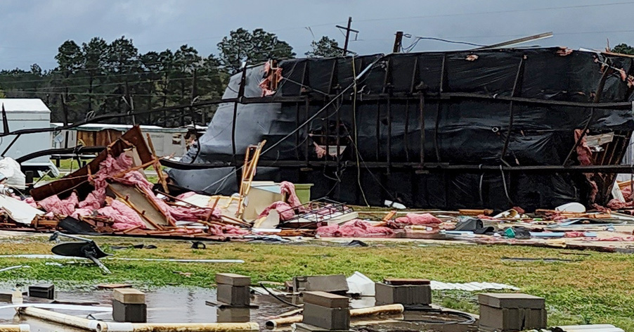
Also, there is missing people north of Atmore due to a tornado. Hope they are found. Storms are worse just to the east of me
NWS Birmingham essentially did the same when they did their update around 9:30 CT this morning dropping the slight risk. Their graphic just says isolated damaging wind gusts to 60mph and quarter size hail. No mention of tornadoes on the graphic.33/40 completely removed tornado wording from their midday update.

Are you going to do doomsday outlooks for that event as well?Got lucky with this one. Next Tuesdays event we might not be.
Lol I didn't do doomsday for this event. Are you going to quote nothing burger incoming and then change your mind saying it's a legit threat? ? I'll do doomsday outlooks if you do that ?Are you going to do doomsday outlooks for that event as well?
This was absolutely a nothing burger.....hence the removal of all mention of tornados in central and north Alabama. The South Alabama threat was legit, and it was pretty much nothing as well. I said exactly what would happen for 2 days, and it did. Could I have been wrong, absolutely, but it seemed pretty clear for the last 18 hours that the HRRR was off its rocker. Better luck next timeLol I didn't do doomsday for this event. Are you going to quote nothing burger incoming and then change your mind saying it's a legit threat? ? I'll do doomsday outlooks if you do that ?
")
Y'all try not to be so salty with eachother please. I think those who contribute to a good service to folks and knowing the upper end of a threat per se is not necessarily a bad thing either. A good blend seems to be the best way to play it but all info is good for digesting in my book.This was absolutely a nothing burger.....hence the removal of all mention of tornados in central and north Alabama. The South Alabama threat was legit, and it was pretty much nothing as well. I said exactly what would happen for 2 days, and it did. Could I have been wrong, absolutely, but it seemed pretty clear for the last 18 hours that the HRRR was off its rocker. Better luck next time
Absolutely, it’s still cloudy here at 63/57Cloud cover has really helped things stay relatively stable this pm over north and central alabama. That was one heckuva workover with the storms this am.
.gif")