gawxnative
Member
Just a "gut feeling" but thinking the cells on the northern edge of that round may very well be the ones to watchCheck out those supercells by Selma at 9 o'clock in the morning. That's a pretty ripe area.
Just a "gut feeling" but thinking the cells on the northern edge of that round may very well be the ones to watchCheck out those supercells by Selma at 9 o'clock in the morning. That's a pretty ripe area.

For the 1st round of storms. I agreeJust a "gut feeling" but thinking the cells on the northern edge of that round may very well be the ones to watch

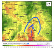
That west-central Alabama tommorow afternoon?That is pretty ominous is things can pop. Can the better shear and instability overlap enough and storms fire just at the right time.
View attachment 115775
Im afraid things will be similar to the no lift event where it took getting in range of bout 5-10 hours before it started actually showing convection intiating. That west Alabama area looks to be my thinking of wear storms will pop around the afternoon. As we get into the 18 hour range tonight I believe the HRRR will start to key in on the potential convection that intiatiates in the state.That is pretty ominous is things can pop. Can the better shear and instability overlap enough and storms fire just at the right time.
View attachment 115775


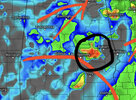
Gotta watch for that crapvection on the coast robbing moisture. That's a healthy little MCS.FV3 hi res shows the redevelopment near the state line of Alabama and Mississippi with supercells popping, although the FV3 is known for being a supercell printer lol.View attachment 115777View attachment 115778
I actually think it'll be the least of our worries. The closer we've gotten the more it's further east and isn't curving in the western gulf. Some models even show the southern end disapating. What you may get is some significant storms in south Alabama if it breaks up more and disapates to storm clusters and cells.Gotta watch for that crapvection on the coast robbing moisture. That's a healthy little MCS.


Fox 6 and nws of bham says they expect a few rouge storms to develop in the afternoon ?.I noticed the 12z NAM had soundings with 0-3km cape around 280 and 700mb wetbulbing around -5C. Tornado threat is conditional, but if anything pops I wouldn’t be surprised to see golf to baseball sized hail.

I’d definitely be concerned with a cell riding the cool side of the warm front. Seen it happen before.Gonna be honest, if the Euro is correct, the Enhanced area needs to be brought up to at least Montgomery for the morning round.
Actually has a strong cell ride the warm front from Montgomery to Columbus that may cause serious problems.
I thought it was low to begin with when it was shown. Bham nws risk outline package may expand further up, but the nws spc should follow suite by the 00z outlookGonna be honest, if the Euro is correct, the Enhanced area needs to be brought up to at least Montgomery for the morning round.
Actually has a strong cell ride the warm front from Montgomery to Columbus that may cause serious problems.


Don’t forget though, those numbers can be really skewed by convection. Try to find a convection free zone to see the true amount.Could definetly see a PDS issued for that south Alabama south Mississippi region. with each new HRRR run it looks more omnious. STP close to maxed out for portions of south Alabama and Mississippi
.png")
The convection free areas are still around 7+ would like to check the EHI. easier to discern environment with that parameter but my favorite forecast website doesn't have ehi on the HRRR lolDon’t forget though, those numbers can be really skewed by convection. Try to find a convection free zone to see the true amount.
Looks like 0-1km EHI is 2-3 across lower MS/AL at the end of the 20z HRRR.The convection free areas are still around 7+ would like to check the EHI. easier to discern environment with that parameter but my favorite forecast website doesn't have ehi on the HRRR lol