-
Hello, please take a minute to check out our awesome content, contributed by the wonderful members of our community. We hope you'll add your own thoughts and opinions by making a free account!
You are using an out of date browser. It may not display this or other websites correctly.
You should upgrade or use an alternative browser.
You should upgrade or use an alternative browser.
Misc 2021-22 Fall/Winter Whamby Thread
- Thread starter jackendrickwx
- Start date
Brent
Member
I'll be waiting for next week's setup to trend out here given how this week went ?
I’m waiting on the radar hallucinations phase of the storm on Sunday3k will have it in Lexington Kentucky by 12z tomorrow but everyone will discount it with the catchy “it’s now cast time.” phrase.
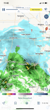
Go sit in the chair. How much? ?About an hour or 2 left of snow! Very much overperformed here!️
11 pmView attachment 105802View attachment 105801
LovingGulfLows
Member
- Joined
- Jan 5, 2017
- Messages
- 1,499
- Reaction score
- 4,100
That looks like 10 inches or so of snow. Very impressive.
It’s blowing and drifting off the roof, so it’s misleading, but fun to look at. About 4-6” in reality, it’s been snowing pixie dust nonstop since 10am. Was forecast as of last night- dusting to 2”Go sit in the chair. How much? ?
Good looking snow! Love a good high end bust. Never had one myself but now I know a guy. ? Just hold onto that snowpack for us. We don’t want our cold air moderating when it drops down out of WinnipegIt’s blowing and drifting off the roof, so it’s misleading, but fun to look at. About 4-6” in reality, it’s been snowing pixie dust nonstop since 10am. Was forecast as of last night- dusting to 2”
Benholio
Member
North GA here hugging the RAP and Canadian models in general ?
Benholio
Member
Getting sappy here, but my boys are about to turn 5 and are finally old enough to get super excited about the chance of snow and actually play in it, etc. So I would take 2 inches of snow out of this system in a heartbeat!
Such a crazy storm to track. Every 12 hours it’s like my team scored or threw a pick-6 in the Super Bowl… except worse.
Good luck to everybody, let’s get some 20 inch totals in the mountains and some surprise bands of 6” in the Deep South!
Such a crazy storm to track. Every 12 hours it’s like my team scored or threw a pick-6 in the Super Bowl… except worse.
Good luck to everybody, let’s get some 20 inch totals in the mountains and some surprise bands of 6” in the Deep South!
Brent
Member
It’s blowing and drifting off the roof, so it’s misleading, but fun to look at. About 4-6” in reality, it’s been snowing pixie dust nonstop since 10am. Was forecast as of last night- dusting to 2”
Hoping for a similar thing here... I definitely think there's potential
Also starting to watch outside it's down to 36 and raining. May get a brief burst with this band
Snowflowxxl
Member
Pretty much every model has ATL getting accumulating snow at this point. Let’s hope
Snowflowxxl
Member
This place will have 50 post an hour for a fantasy storm at day 8 but the night before the biggest storm in years it’s crickets. What the hell
Benholio
Member
The quiet before the storm right?This place will have 50 post an hour for a fantasy storm at day 8 but the night before the biggest storm in years it’s crickets. What the hell
i think most everybody is exhausted at this point. The fun part of tracking is all but over. Now we move into the event phase. Then we move into the phase where we realize we probably won’t have another opportunity to score again for a very long time.This place will have 50 post an hour for a fantasy storm at day 8 but the night before the biggest storm in years it’s crickets. What the hell
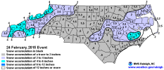
That system on the GFS reminds me of this little overperformer in Feb 2015. It was an appetizer to the main event a day later but was a pretty significant event on its own. Precip amounts were very light (less than 0.1" total) but there was no mixing, and it snowed for most of the day in the low-mid 20s. Roads were completely covered, and schools had to close early in the morning. An inch and a half of powder was pretty cool, I'd take this over a mixed bag storm with 10x the QPF any day

SimeonNC
Member
Looks like the East Coast will be getting a taste of what Texas got last year with the cold.
FYI an advisory is a UPGRADE technically from a winter storm watch
3. Watch
2. Advisory
1. Warning
3. Watch
2. Advisory
1. Warning
FYI an advisory is a UPGRADE technically from a winter storm watch
3. Watch
2. Advisory
1. Warning
Good point
NCHighCountryWX
Member
- Joined
- Dec 28, 2016
- Messages
- 699
- Reaction score
- 1,918
Unfortunate BUST for snow started unfolding Friday afternoon and has now become solid as an 850 going up west and over the Apps won’t allow other than nuisance front end snow east of the mountains.
Fingers crossed for all in the icing areas that the NAM warm nose continues to strengthen to limit ice accretion
NAM and HRRR is the king on critical thermal profiles and the lesson is again re-enforced that in marginal snow situations nothing is to be trusted outside of 36-48 hours
Fingers crossed for all in the icing areas that the NAM warm nose continues to strengthen to limit ice accretion
NAM and HRRR is the king on critical thermal profiles and the lesson is again re-enforced that in marginal snow situations nothing is to be trusted outside of 36-48 hours
I still have no idea what I should be preparing the farm for today. Parella Lewis said a trace to inch. Models look more than that...Lawd. So confused.
NAtlantaStudio
Member
Same. But then again I never understand what the NWS does with my Forsyth County. Usually the top half of my county has the same weather as Dawsonville and the bottom half is drier and closer temps to Fulton so they usually put align our county forecast with the metro counties.I still have no idea what I should be preparing the farm for today. Parella Lewis said a trace to inch. Models look more than that...Lawd. So confused.
Snownut
Member


Sent from my SM-A526U using Tapatalk
ALHammerWx
Member
- Joined
- Jan 4, 2017
- Messages
- 61
- Reaction score
- 117
I need some nutty clown maps for North AL to get me excited. I will say the Jan 2-3 snow definitely outperformed in Blount Co anyways. I didn’t expect more than a dusting with ground temps over freezing and lots of rain before. But once the changeover happened, the ground covered quickly and we had 3 inches total.
^ it looks so clean too. merry christmas.
raine1212
Member
Lol… I go to bed with all rain, wake up to an advisory . Dreading the wind with all these trees around my house, it doesn’t take much for power outages here. Maybe I should not live on the savannah river lol
Folks don't get sucked in again for next Friday. Not in the Carolina's at least for snow. I've watched the NWS constantly lower my snow totals this event from 6-8 to 4-6 now down to 2 inches. Don't fall for it guys. The warm nose will always be way stronger than modeled and surface temps will always trend warmer 24 hrs before go time. Happens every single time. I guess I'll enjoy my ice storm and hope I keep power.
D
Deleted member 609
Guest
Still standingWhamby is quiet tonight. @Broken024 how’s your house doing?
Is today the day NC is supposed to get the finger of rain??^ it looks so clean too. merry christmas.
GarnerNC
Member
28 this morning, so excited for mid 40s and rain tomorrow, while the deep south gets snow, I live for it.
LickWx
Member
Today’s the finger tomorrow’s the reach around .Is today the day NC is supposed to get the finger of rain??
Cad Wedge NC
Member
Oh, there will be plenty of folks getting the finger with this storm....... in the way of power outages.Is today the day NC is supposed to get the finger of rain??
It’s better when you combine themToday’s the finger tomorrow’s the reach around .
Can Athens get a solid snow event please? Every new storm looks good for a second then always shifts north like this one with the coastal low not being as far south for us.
And not just Athens like, it would be awesome for folks even further south down to Macon or so to have a good snow for a change. Same with our friends in South Carolina who seem to always miss out.
And not just Athens like, it would be awesome for folks even further south down to Macon or so to have a good snow for a change. Same with our friends in South Carolina who seem to always miss out.

