Brent
Member
It almost a like a hybrid cold core low. That gets sucked in a surface front. Very weird look on the gfs.What a tease ? barely south of meView attachment 99467
It almost a like a hybrid cold core low. That gets sucked in a surface front. Very weird look on the gfs.
Column really crashes. Watch out NC folks there’s potential for maybe some backside deformation happiness with this system placement of the low and strength will all be crucial to whether we are even able to see something here but I’d look for that possibility as there will be some good dynamics at play here … would probably not accumulate much at all unless this thing trended real south and exploded as it’s own system
I love a big 1052 man CAD signal showing up right under 240 hours
Please let this happen.
Finally getting that big low over the Aleutians. If this isn’t another fake, it’s gonna get cold with that look.Bad trends out .. good trends in .. past three runs .. west coast looking beautiful View attachment 99469
Not very Nina-like.
Looks like a complete miss.00z Euro doesn’t dig as much. I think I’ll toss this run if it ends up well as just the SW trough bias.

Probably won’t take that long the more amplified it is. It’s more of a -WPO than -EPO. Usually about 5 days before it’s over SiberiaIt’s going to take a week to shove the pacific ridge north and away from the pacific. Then we may see what the 2nd week of January brings. The models are likely going to struggle to find the correct solution until then.View attachment 99481View attachment 99482View attachment 99483View attachment 99484View attachment 99485
Wasn't bad. There is a good % of the eps members that are highs 35-50 lows 22-30 for us starting 1/7 not entirely sure why the lows are so warm unless we are just getting wedged to deathI sure hope EPS looked better than the Euro last night
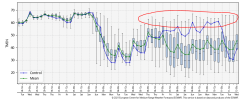
I know this is the high end of the output, but I hate seeing that possibility. Enough with lows in the 60s.Here are the eps spreads for bhm and atl. Interesting to note there's a decent % of the members that have highs near or below 30 at both locations on 1/7 View attachment 99497
View attachment 99498

What is hard freeze now, 29?Icon has a hard freeze for Atlanta Sunday night Monday morning. A few cold days and then a quick warm up, maybe? This is exactly how I anticipated the trough to respond once it moved back into the eastern US. In and out, and no long term reinforcement of cold air. We may even slide back into the December pattern by mid-month.
I remain grounded in reality and discount all optimistic outlooks for snow in Atlanta this year. It would have to be timed perfectly. Maybe some flurries behind a strong cold front if the parent low tracks close enough? That is all that seems realistic for this winter season. That's not saying much because that's all that is realistic for any winter season in Atlanta.
Yeah just looking at the overall mean pattern on the gefs and eps it's easy to see why they are there. We really have to couple the block north of AK with some semblance of ridging along the west coast to establish some meridional flow and drive the cold south and push the mean trough axis east otherwise a flat pac here sets up an ugly gradient with marginally close Miller b events along and north of I40 and in the wedge regions and warm southI know this is the high end of the output, but I hate seeing that possibility. Enough with lows in the 60s.
View attachment 99499
So you’re a glass half empty guy huh .. there’s an equal opportunity that lows are in the teens .. both sides of that spectrum have equal chance of happeningI know this is the high end of the output, but I hate seeing that possibility. Enough with lows in the 60s.
View attachment 99499
Eh look no further than the Euro control to see how even with changes in the npac this pattern can easily fall into the toilet and we just alternate cold/warm with really 0 chance of snow while the northern tier of the US gets cold. I feel ok for our region (central nc)to at least make a run at something mid month but there is still a good amount of oof, golf, beach, cactus potential hereSo you’re a glass half empty guy huh .. there’s an equal opportunity that lows are in the teens .. both sides of that spectrum have equal chance of happening
Good look for Newfound Gap.
Along and west of the mountains that is fairly believable and a good output of what probably will happen if we can get the cold air rushing in fast enough. Personally I think the only places in NC that will have a chance at seeing flakes fly is along and east of 95. Cold air is always slower coming across the mountains than what the models show and its hard for anyone in the piedmont or upstate to score in these types of setups of cold chasing moisture.
@Myfrotho704_ jackpot. We toss.
