champal3003
Member
With it being a Tropical Storm all the way up into AL now, will the winds and gusts have to be updated higher than previously predicted. It looks like it will still be a storm when it gets to my area.
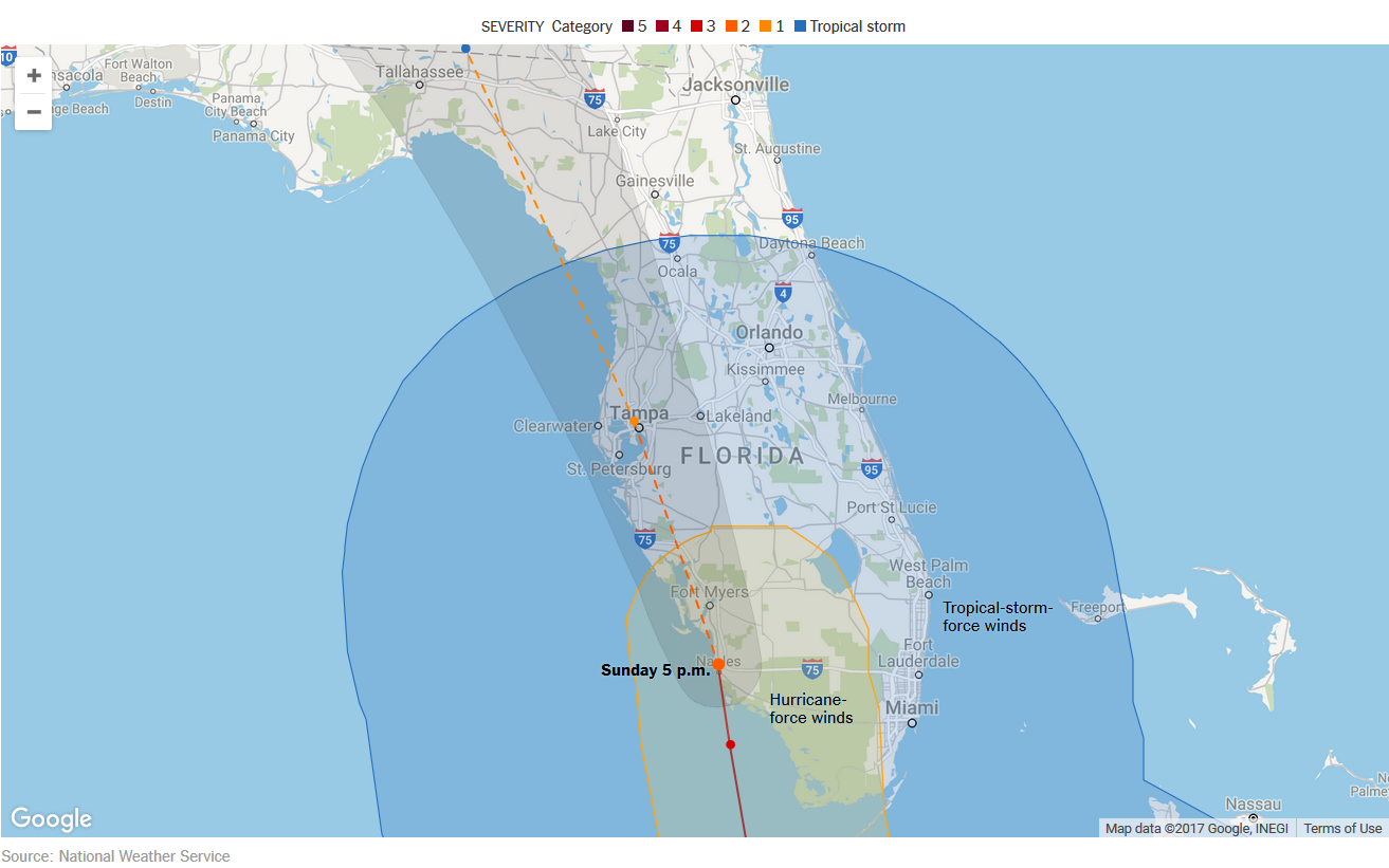
That's good and well but it cannot make the next point without a turn within an hour. Just not possible, no matter what NHC believes.
Yep it will. At some point. It's got to within the hour to make the next point. I think the turn somewhere in South Georgia based on climo.The turn NW will happen. It’s behaving like mostly the euro with some gfs blend
I've never said it wouldn't turn NW. I was saying based on the 5pm NHC map, it will have to turn NW within the hour to make next point. The SW appears weaker so that's one reason I think the turn occurs further north. Also climo suggests that too.So, you are hell bent on this thing not turning NW whatsoever...we all get that by now (you've posted 28 times about it), but can you add substance to your stance of why you know this wont turn NW?
I threw climo out the door after she passed Hispaniola. Climo said she would go OTS. Irma doesn't play by climo.Yep it will. At some point. It's got to within the hour to make the next point. I think the turn somewhere in South Georgia based on climo.
He said climo which is true . But Irmas path from where she was just North north of PR to where it turned is alreAdy against climo as GaWx pointed out numerous times that a more wnw path is more climo like vs a sharp turn North . Storms don't always follow climoSo, you are hell bent on this thing not turning NW whatsoever...we all get that by now (you've posted 28 times about it), but can you add substance to your stance of why you know this wont turn NW?
Got you, Major Tom!Ground control to Phil. You should start getting into the part of the storm with the most instability in the NE quad in the next hour or so. The couplets and curved cells are relentlessly coming on shore. Get radar scope on your phone if you don't have it!
Hang in there Phil, and heed Jackstraw's advice.FWIW - wish tomorrow was another Monday wondering and worrying about if the phone will ring, and when it does, what sort of client problem needs to be dealt with ...
In other words ... the cluster is no fun ...

Yeah Irma hasn't played by climo rulesI threw climo out the door after she passed Hispaniola. Climo said she would go OTS. Irma doesn't play by climo.
An interesting observation about those couplets/curved cells - they are curved the opposite direction than the ones in the 4/27/2011 outbreak.Ground control to Phil. You should start getting into the part of the storm with the most instability in the NE quad in the next hour or so. The couplets and curved cells are relentlessly coming on shore. Get radar scope on your phone if you don't have it!
JS has never sent me in the wrong direction .. when it's raining, all night pouring, he always ducks me into a bar door, without a drop on me ... test me ... LOLHang in there Phil, and heed Jackstraw's advice.
...it def. trending toward the euro on that solution. GFS must be a little stronger further inland this run?@deltadog03 18 GFS shows slightly higher winds than 12z View attachment 1187 View attachment 1188 View attachment 1189
its about the same as 12z, but 6z definitely has a stronger lowgood find! ty
...it def. trending toward the euro on that solution. GFS must be a little stronger further inland this run?
Yeah, and these are some high topped super cells out there coming in. I've seen some up over 55k ft. Very strong updrafts which is very unusual in a TC. A lot of these aren't typical frictional induced TC spawned tornado sigs. I tracked one really strong isolated cell with a consistent couplet over 75 miles. Thats border line long tracker. If that instability maintains could be a really scary issue as the storm moves north and the landmass expands into that area.An interesting observation about those couplets/curved cells - they are curved the opposite direction than the ones in the 4/27/2011 outbreak.
It's a fact as from this morning. She isn't going to be a major going up by you now!power - on for a few, off for many, on again now -- quick look - and I may be 1000% wrong -- she looks a bit weaker coming north than progged ... ????
@deltadog03 18 GFS shows slightly higher winds than 12z View attachment 1187 View attachment 1188 View attachment 1189
About 50 to 55 for our area it seems per that run.So how do those equate in mph?
Sent from my iPhone using Tapatalk
yeah, anything in yellowish-orange is >58 mph...About 50 to 55 for our area it seems per that run.
Don't mention the west trend around here. The euro and NHC said it's gonna happen and by gosh that's the gospel. It was supposed to have already happened. 0Z short range models NAM and RGEM will be interestingso when is this west motion starting?
Funny we couldn't stop the west trend and now it refuses to move west

Don't mention the west trend around here. The euro and NHC said it's gonna happen and by gosh that's the gospel. It was supposed to have already happened. 0Z short range models NAM and RGEM will be interesting