Holy crp...6Z GFS puts N.O. squarely in the right front quadrant. Yeah, wobbles sometimes do matter.

I can't confirm but I've been watching the eye contract all morning on the radar so I wouldn't doubt there's lower pressure to be found.I'm looking at the NOAA43 track, I don't believe they *punched* the Eye & got the correct pressure, can anyone confirm?
never mind....lol 145mph nowI think she has peaked as well. Should maintain or maybe bounce back a little more strength on the way in.
NOAA about to punch the center:
AF is closing in:
it has...been tracking it more with radar at this point, but sat images look very impressive.Man you seeing the eye on vis it's clearing out quick. Big round eye.
THAT'S ALMOST A DUE NORTH MOVEMENT ACCORDING TO VISIBLE SAT IMAGESI fear this NNW jog is more of a heading than a jog. Severe impacts to Jefferson, Orleans, Plaquemines, and St. Bernard Parishes are becoming more likely by the hour.
 ️
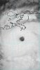
️ This is the sickest radar image I have seen of a cane … a lot of the other hurricanes we’ve tracked I feel like usually have a lopsided but strong partial eye wall .. this thing is full ring of death️ View attachment 89648
HWRF For the win one could argue the live picture looks better than the model. Scary stuff.View attachment 89650View attachment 89651
I remember that happening in MichaelThe wind speeds on velocity have exceeded maximum values of 141 mph .. those hot pinks around this area of darkness aware those 141 values .. what’s in the dark values I’m sure it more View attachment 89653


 ️
️