-
Hello, please take a minute to check out our awesome content, contributed by the wonderful members of our community. We hope you'll add your own thoughts and opinions by making a free account!
You are using an out of date browser. It may not display this or other websites correctly.
You should upgrade or use an alternative browser.
You should upgrade or use an alternative browser.
Tropical Hurricane Ida
- Thread starter Snowfan
- Start date
Tornadocane
Member
My cousin posted this today in Facebook. Bet she hasn't considered lugging groceries up 17 flights of stairs if the elevators arent working due to no power. She is going to regret the decision to not hop on a flight out.
She thinks grocery stores are going to be open? I remember pictures in the newspaper of people wading in waist-deep water to get to the grocery store after Katrina, and there were alligators and sharks in swimming around in all that brown.
I won't be surpised if it's already at low to mid-end Cat 3. That storm is taking off.Yeah
Brent
Member
Yeah
Yeah... I see why they sent emergency recon because yikes
SWVAwxfan
Member
Can we keep the global warming talk in the global warming subforum..It’s taken a while to understand and for many they don’t wanna believe it but global warming has caused ocean temps to run much warmer than normal and the waters in the gulf are no different.. the waters everywhere now can support and sustain major hurricane all the way to the coast lines … it used to be only certain areas would have those type of temps but now that expands and warms so the warm spots are warmer giving bigger booms to storms now and the cooler spots now are warm and can sustain those strong storms … IMO of course this is what I think is happening
Yeah, my 115mph "underperformer" wag at landfall isn't looking too good right about now.Yeah... I see why they sent emergency recon because yikes

IR arguably best yet…

Ida is looking to take a track very close to that of Betsy of 1965 just SW and W of New Orleans at possibly a similar strength. My friend who grew up there and experienced it in his house as a kid was just telling me about it. They had no flooding, but the winds were blowing all night and it was pretty terrifying. Fortunately, their house was left intact though they did lose their fence, which itself caused the loudest noise of the night. A night he’ll never forget. It was because of storms like this that he and his wife moved to Atlanta as a young adult. He doesn’t miss NO at all and will never move back there or anywhere near the Gulf or Atlantic coast. At most, he takes occasional trips there.
Shaggy
Member

Funny. That guy could almost be me.Ida is looking to take a track very close to that of Betsy of 1965 just SW and W of New Orleans at possibly a similar strength. My friend who grew up there and experienced it in his house as a kid was just telling me about it. They had no flooding, but the winds were blowing all night and it was pretty terrifying. Fortunately, their house was left intact though they did lose their fence, which itself caused the loudest noise of the night. A night he’ll never forget. It was because of storms like this that he and his wife moved to Atlanta as a young adult. He doesn’t miss NO at all and will never move back there or anywhere near the Gulf or Atlantic coast. At most, he takes occasional trips there.
I remember Betsy as a seven-year-old like it was yesterday. Everything from the beautiful blue skies the morning of and riding my bike with the wind at my back while my mom tended her flowers, to watching my dad try to nail a chalkboard to seal a blown-out window while rain and leaves poured through. Bricks slamming the house, the floorboards shacking, and finally, as one of the few homes in the area not underwater, we became a safe house.
I've been a weenie ever since.
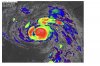
Here’s another two hour update.. first image is 2 hours ago second is current.. spot the difference again ?? We are looking at a major hurricane

We are looking at a major hurricane This could be seen as a very scary looking face if you take into account the second area of convection to the west of idaHere’s another two hour update.. first image is 2 hours ago second is current.. View attachment 89603
View attachment 89604
This storm is giving me chills right now
Did someone say Betsy? Not quite, but it's getting there.

This storm is giving me chills right now
Cadi40
Member
Ida is truly terrifying, it’s almost like it knows where New Orleans is. Not to mention tommorow is 16 years since Katrina.
Latest Dvorak estimates
CI# /Pressure/ Vmax
5.6 / 953.6mb/104.6kt
CI# /Pressure/ Vmax
5.6 / 953.6mb/104.6kt
NBAcentel
Member
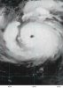
Eye is really clearing out signaling convection warming the core, might have a 3 
Eye is really clearing out signaling convection warming the core, might have a 3 View attachment 89606
Definitely have a Cat 3 probably will be closing in on Cat 4 in the next few hours.
I'm betting this makes landfall as a low-end Cat 4. I was skeptical because of yesterday but seeing this boom, I don't see it being stopped from being a Cat 4.
oh ----
I feel like it always appears the storm is moving slower when that eye finally pops and clears … just staring back at you … visible imagery tomorrow morning at sunrise could be absolutely stunning and terrifying .. why do I feel so much guilt for actually anticipating on those slow motion GOES satellite images ?
Shaggy
Member
I'm betting this makes landfall as a low-end Cat 4. I was skeptical because of yesterday but seeing this boom, I don't see it being stopped from being a Cat 4.
Could still.throw In an EWRC that could end intensification.
Could still.throw In an EWRC that could end intensification.
Probably not gonna have enough time.
accu35
Member

Shaggy
Member
Plane should be there in short order so we will get a better look. Definitely gonna see sub 960 IMO
Webberweather53
Meteorologist
Looks like another area of disturbed weather may develop later this week in the same portion of the Caribbean where Ida developed late last week. Genesis also looks similar to Ida w/ monsoon trough, tropical wave, upper low over the Bahamas, and Kelvin Wave all interacting to potentially yield development in the western Caribbean. Environment is there as is some model support. Not quite as confident (yet) in this one as I was w/ pre-Ida, but it's going to have much better timing w/ the Kelvin Wave (most TCs form about 2 days after passage). Here's a mini-thread I made on it. Hopefully, this one stays down near Central America...
Getting a sinking feeling about that wave in the SW Caribbean that we may be doing this again in a week or so...
The VPM MJO phase composite looks about right for the wave coming off Africa now & suggests the Gulf coast and central America should be on alert.


Shaggy
Member
Probably not gonna have enough time.
Doesn't have to finish it just start it that would be enough to end the RI
Forecast discussion from N.O. forecast office:
 forecast.weather.gov
SNIP:
Winds will be dangerous to destructive through our entire CWA. The
most destructive winds will occur along the coast of Louisiana where
devastating structural damage could occur as winds are expected to
gust over 160 mph! This will severely damage to destroy most
structures that are not well built. Locations around New Orleans
could see winds that are far stronger than what was experienced last
year during Hurricane Zeta with much of the area likely seeing winds
gusts in excess of 100 mph. If there is any more of a jog east these
winds will be even higher. Winds funneling through some of the high
rises will be even stronger. Around Baton Rouge we could see wind
damage that far eclipses what was seen during Hurricane Gustav.
Winds gusts over 110 mph are possible that far inland. This will
lead to widespread tree damage, structural damage, and massive power
outages which could take weeks to restore. Across southwest MS winds
will remain very strong likely gusting over hurricane force around
Wilkinson County and gusting to near hurricane force as far east as
McComb. Northshore areas, especially along the lake could see wind
gusts over hurricane force with widespread tree damage and power
outages. Coastal MS likely to see winds gusts over 60 mph at times
which could still lead to damage and widespread power outages.
National Weather Service
forecast.weather.gov
SNIP:
Winds will be dangerous to destructive through our entire CWA. The
most destructive winds will occur along the coast of Louisiana where
devastating structural damage could occur as winds are expected to
gust over 160 mph! This will severely damage to destroy most
structures that are not well built. Locations around New Orleans
could see winds that are far stronger than what was experienced last
year during Hurricane Zeta with much of the area likely seeing winds
gusts in excess of 100 mph. If there is any more of a jog east these
winds will be even higher. Winds funneling through some of the high
rises will be even stronger. Around Baton Rouge we could see wind
damage that far eclipses what was seen during Hurricane Gustav.
Winds gusts over 110 mph are possible that far inland. This will
lead to widespread tree damage, structural damage, and massive power
outages which could take weeks to restore. Across southwest MS winds
will remain very strong likely gusting over hurricane force around
Wilkinson County and gusting to near hurricane force as far east as
McComb. Northshore areas, especially along the lake could see wind
gusts over hurricane force with widespread tree damage and power
outages. Coastal MS likely to see winds gusts over 60 mph at times
which could still lead to damage and widespread power outages.
Tornadocane
Member
I'm going 952 Mbs on first pass. She's frigg'n gorgeous right now.
Holy cow this one is for real 
accu35
Member
Nice north wobble
Shaggy
Member
I'm going 952 Mbs on first pass. She's frigg'n gorgeous right now.
Plane should be getting ready to get a center fix in the next few minutes
955mb 120mph if I had to take a stab at current intensity, we will find out shortly.
Did someone say Betsy? Not quite, but it's getting there.
View attachment 89605
I was just looking up Betsy's stats and it landfalled over the LA swamps with 140 mph highest sustained winds and 942 mb pressure, both the strongest of its entire existence in solid cat 4 territory. Hopefully, Ida won't be quite as strong at landfall since the 0Z GFS shows 956 and the NHC has 130 with a hopeful slight weakening just before landfall, but those higher Betsy numbers are not unreachable unfortunately on the high end of potential. As it is, 956 would be bad enough with that being a solid cat 3 and bringing the N.O. area about the worst of the storm in regard to winds, surge, and very heavy rainfall.
Tornadocane
Member
955mb 120mph if I had to take a stab at current intensity, we will find out shortly.
Why the hell not?
I bet you get dropsonde while I get Extrapolated Surface Pressure. It's been 3Mb difference pretty much all day.
CI# /Pressure/ Vmax
5.7 / 951.4mb/107.2kt
Last Dvorak estimate before recon comes
5.7 / 951.4mb/107.2kt
Last Dvorak estimate before recon comes
HWRF for 2 am … going to be pretty damn close .. pressure at 952 here as well (18z)
I’d say the HWRF is doing alright for itself 
Shaggy
Member
The planes made the turn towards the core and is heading in so in the next 10 to 15 minutes we should know how fast its dropped pressure.
As I recall, one of the reasons Betsy had such an impact to its northeast was as a mature storm it had an unusually large eye for a landfalling cat 3/4. I've never looked up its IKE, but that would be interesting if it exist.I was just looking up Betsy's stats and it landfalled over the LA swamps with 140 mph highest sustained winds and 942 mb pressure, both the strongest of its entire existence in solid cat 4 territory. Hopefully, Ida won't be quite as strong at landfall since the 0Z GFS shows 956 and the NHC has 130 with a hopeful slight weakening just before landfall, but those higher Betsy numbers are not unreachable unfortunately on the high end of potential. As it is, 956 would be bad enough with that being a solid cat 3 and bringing the N.O. area about the worst of the storm in regards to winds, surge, and very heavy rainfall.
Also, there was a strong surface ridge that had driven the storm SW into Florida and that gradient piled water into SE La. on those stiff NE winds for days prior to landfall. Ida will be different, but may actually bring wind to perhaps a smaller area just as strong, or perhaps a bit more.