Henry2326
Member
I honestly think “underperformer”was used moreso as like, it’s not going to be the “demise of NOLA” that we thought it was going to be. Granted, even at 115mph, it will still be a formidable force that warrants the current evacuations that are taking place
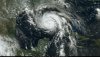
I guess you have to describe demise. The first map shows Morgan City in relation to New Orleans. The second shows the surge estimates for a cat3 storm. The entire area will be covered in water with the storm pushing surge into NO. Listening this morning to the manager of the "pumps", I didn't walk away with the feeling this was going to work. There are 96 pumps and they only pump 1/2 inch per hour. As with Harvey, we will have to wait and see whether demise is characteristic of wind or water,
We watched this identical process with Michael where the models lit up then backed off, then lit up again. I'm hoping for the best case scenario for any place on the gulf, bur don't think we are far enough along to call it an "underperformer". It gives people a sense of relief that has no place at this time. Preparation is key in saving lives with the information we have.