This is ida’s blob I be talking about … until it goes away or joins the circulation it’s going to keep her at bay .. as soon as you see it disappear I bet it’s off to the races IMO
-
Hello, please take a minute to check out our awesome content, contributed by the wonderful members of our community. We hope you'll add your own thoughts and opinions by making a free account!
You are using an out of date browser. It may not display this or other websites correctly.
You should upgrade or use an alternative browser.
You should upgrade or use an alternative browser.
Tropical Hurricane Ida
- Thread starter Snowfan
- Start date
HSVweather
Member
Northeast of NHC track
HSVweather
Member
Henry2326
Member
Webberweather53
Meteorologist
Henry2326
Member
Henry2326
Member
Crazy situation......it shouldn't be this difficult.
Henry2326
Member
Webberweather53
Meteorologist
Crazy situation......it shouldn't be this difficult.
They may not have had enough time to get everyone out of the city but doing something is better than nothing
Blue_Ridge_Escarpment
Member
Better than some evacuations I’ve seen in recent weeks. Sad both ways.They may not have had enough time to get everyone out of the city but doing something is better than nothing
Stormsfury
Member
See it time and time again with poleward tugging, battlegrounds when Ida is in blowup mode how the cyclone is tugged slightly right. When we had a phase overnight, where it was "repairing" itself so to speak, it seemed to turn a bit left (315-320 degrees NW)..
But overall, Ida has been consistently on the right edge of the consensus. This could put New Orleans directly on the eyewall or eye itself if these trends continue.
But overall, Ida has been consistently on the right edge of the consensus. This could put New Orleans directly on the eyewall or eye itself if these trends continue.
Btw, don't look at the steering currents if this can get to the 940's range. Lol. If so, they are def east of central LASee it time and time again with poleward tugging, battlegrounds when Ida is in blowup mode how the cyclone is tugged slightly right. When we had a phase overnight, where it was "repairing" itself so to speak, it seemed to turn a bit left (315-320 degrees NW)..
But overall, Ida has been consistently on the right edge of the consensus. This could put New Orleans directly on the eyewall or eye itself if these trends continue.
Cadi40
Member
Even with the eastern wobble this is undoubtedly going to be a Louisiana storm, and most definitely one NOLA will remember for a long time. With this latest NNW movement it puts the projected track even closer to NOLA, exactly where I don’t want it to be.
Webberweather53
Meteorologist
Looks like another area of disturbed weather may develop later this week in the same portion of the Caribbean where Ida developed late last week. Genesis also looks similar to Ida w/ monsoon trough, tropical wave, upper low over the Bahamas, and Kelvin Wave all interacting to potentially yield development in the western Caribbean. Environment is there as is some model support. Not quite as confident (yet) in this one as I was w/ pre-Ida, but it's going to have much better timing w/ the Kelvin Wave (most TCs form about 2 days after passage). Here's a mini-thread I made on it. Hopefully, this one stays down near Central America...
Stormsfury
Member
Btw, don't look at the steering currents if this can get to the 940's range. Lol. If so, they are def east of central LA
Well, I'm a bit anxious to see what next RECON will find. Apparently, I'm seeing mesovorticity action in the eye.. plus with the last convective blowup on the inner northern eye, you could actually see anvil blowoff forced down into the eye itself on that visible closeup someone posted.
The 976mb was an estimate at 2pm. I think we should see next RECON find sub 970mb. Realistically, a 25mb fall is quite probable considering Ida's remarked improved look.
Z
Zander98al
Guest
Governor ivy declared a state of emergency for parts of Alabama ahead of Ida.
Sent from my moto g power using Tapatalk
Sent from my moto g power using Tapatalk
Storm5
Member
Governor ivy declared a state of emergency for parts of Alabama ahead of Ida.
Sent from my moto g power using Tapatalk
Free off days for schools now
Sent from my iPhone using Tapatalk
accu35
Member

Jim Cantore and Levi Cowan stated they notice the a NNW jog in the past 6 hours.
CDO still swirling. Need it to ring out for RI.
Blue_Ridge_Escarpment
Member
Yep. TWC saying right now it’s very troubling that it’s outside the cone essentially now.View attachment 89515
Jim Cantory and Levi Cowan stated they notice the a NNW jog in the past 6 hours.
So I finally got back from a honey-do mission. I can't help but notice as others have pointed out that the storm has been riding the eastern edge of guidance the past few hours. Not to mention a rather substantial shift east on the EURO. New Orleans/Metairie may just find itself in the NE eyewall after all.
850mB winds. Not surface! But still. That eastward adjustment is concerning.

850mB winds. Not surface! But still. That eastward adjustment is concerning.
accu35
Member

Tornadocane
Member
I brought her name up to my friend in Baton Rouge, and he started laughing. Apparently, Cantrell had been advocating for a monument to herself in the City, and thinks the only reason she doesn't have one is cause she is black and a woman, even though the city is made up of a majority of black citizens that voted for a female mayor. Oh by the way... She's only been there for 2 years and half the city hates her. She also doesn't seem to realize that it's poor edicate for politicians to be given monuments during their time in office. She constantly plays political games.
When you live in a city is constantly under threat by hurricanes that could wipe out the lives and property of your friends and family, you vote for the civil engineer or the emergency manager. You don't vote for the candidate running as the first female mayor, unless she has a degree in civil engineering or experience as an emergency manager. You'd think that the people who experienced a humanitarian crisis like Katrina would elect someone that was qualified to handle such incidents.
HSVweather
Member
Cadi40
Member
Wow it’s almost like Ida knows where Bourbon Street is and she wants in.
Yeah honestly looks like the bands have wrapped around her nicely through the afternoon .. it’s coughed out that dry air almost fully now and right in time for a big ole pocket of very warm water … by evening time we will be looking at a major hurricane
Brent
Member
Yeah honestly looks like the bands have wrapped around her nicely through the afternoon .. it’s coughed out that dry air almost fully now and right in time for a big ole pocket of very warm water … by evening time we will be looking at a major hurricane
Yeah it seems like they usually bomb at night so I don't think the window is closed yet for sure. The loop current is still ahead of it
accu35
Member

Eye is trying to clear. It would take a good clip west to get back on track. TWC is concern for New Orleans or little east of there if this continues.
Storm5
Member
Still plenty of time for wobbles to the west it's not that far off the track
Sent from my iPhone using Tapatalk
Sent from my iPhone using Tapatalk
MichaelJ
Member
As I mentioned two days ago, I had a feeling the high would weaken enough to allow this to be a problem from NO to Mobile. While it may go through Eastern or central Tn, the bulk of the heavy rain and flooding will be to the east of the low passage, not the west. Therefore people in the NC/Ga mountains need to keep a sharp lookout for flooding rains if this takes a sharper NE turn after landfall than expected
DadOfJax
Member
?Still plenty of time for wobbles to the west it's not that far off the track
Sent from my iPhone using Tapatalk
this is still right on track to be just west of NOLA
The NW by NNW wobble is looking more and more like a heading.

lexxnchloe
Member
Luckily thats alot weaker than Betsy.So I finally got back from a honey-do mission. I can't help but notice as others have pointed out that the storm has been riding the eastern edge of guidance the past few hours. Not to mention a rather substantial shift east on the EURO. New Orleans/Metairie may just find itself in the NE eyewall after all.
850mB winds. Not surface! But still. That eastward adjustment is concerning.
View attachment 89518
I agree. While it does look like it will be east of the 11am track, the eye should still come in just west of New Orleans. Unfortunately it looks like a greater possibility that the city may at least get clipped by the eye wall.?
this is still right on track to be just west of NOLA
EMTime
Member
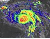
She's looking much healthier now.
Jessy89
Member
Be interesting to see how the new track is adjusted here in about 20 minutes or so.
Sent from my iPhone using Tapatalk
Sent from my iPhone using Tapatalk
Blue_Ridge_Escarpment
Member
Gonna have to go East for sure. Heck the eye is out of the cone now.Be interesting to see how the new track is adjusted here in about 20 minutes or so.
Sent from my iPhone using Tapatalk
Yes, it is thank goodness. Betsy was a much larger storm too.Luckily thats alot weaker than Betsy.
Unfortunately, after a sluggish night and early morning, Ida does seem to be putting on quite a show at the moment.