lexxnchloe
Member
Getting scary looking now.

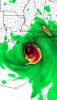
It looks more bad than 2017.Crazy how that bubble of extra high ocean heat content just happens to be in the perfect position for a relatively maximum usage from IDA … it just looks like a recipe for something spectacular to be witnessed .. but maybe it’s just more run of the mill … I think not View attachment 89280

The match is lit right next to the gasoline … tick tock… tuck tock BOOM ?This thing looks ready to go nowView attachment 89285
Significantly ..HMON coming in way stronger through 45hrs.
Edit: Cat 2 by 51hrs.
Recon is on the way. Let's see where the true center is. I expect a 50+ TS when they get there.
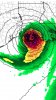
I WOULD HAVE TO AGREE, THEM CLOUDS ARE RACING TO THAT LLC AND THEM HOT TOWERS TO THE NORTH ARE FIRING OFF RAPIDLYIt sucks because it's night time but the vis/IR loop shows the low cloud field really accelerating into the LLC. Wouldn't be surprised if they find a much better LLC this time and a strengthening storm.
AF301 IS INBOUND SO IT WONT BE TO LONG, THAT SHOULD BE A LOWER LEVELI'm a goof. That was an upper level mission. I think we have to wait a little longer for recon.

Yep not good at all for several reasons.
THAT IT IS, I HOPE THOSE PPL HEED THE WARNINGS AND TAKE THIS SERIOUSLY
I'm a goof. That was an upper level mission. I think we have to wait a little longer for recon.
Grand Cayman Raadar.. OH MY.. Weather in Cayman - Radar
Wow. can see where the eye will be
THEY NEED MASH THAT SKINNY PEDAL AND GET ON OUT THERE. BUNCH OF PEPAW DRIVERS ?Much improved over yesterday but still work to do. The storms over the center look a little beat up still. Once we see that big symmetric CDO then we know it's really gonna take off.
Still wouldn't surprise me to see a 50mph storm when recon gets in there.

Yeah, this is nothing new, in fact it seems they are weaker than they were 30 years ago, and seem to have a hard time getting thier act together.As they did 10,20 and 30 years ago
Sent from my iPhone using Tapatalk