Round Oak Weather
Member
Question what website it this with?
Question what website it this with?
Question what website it this with?


GFS has another black hole after day 10. The cold shots just keep coming.Then GFS has NW flow show for the mountains after wave two. This is a great white Buffalo setup here

Western slopes are gonna get creamed as it stands
 ?
?


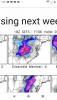
Man that wave has my interestFWIW the GEFS has a little action with wave 2View attachment 53823

The way I look at things, we gotta wait and see what wave 1 does because it will ultimately have some influence on what wave 2 does.Man that wave has my interest
Sent from my Pixel 3 using Tapatalk
Someone correct me if I'm wrong, but this looks to be at least part of the reason the precip died out with the second wave.. our upstream "moisture" source is bone dry
View attachment 53824


Hopefully the ull can keep on shifting south of us so we can get in on the action as wellThat first wave is good for Georgia but not South Carolina
Sent from my iPhone using Tapatalk
Hopefully the ull can keep on shifting south of us so we can get in on the action as well


Only problem is that there’s many things that can go wrong with this setup and you need it to be exactly perfect, things that can go wrong is 1. that the cold source (which is the UL trough) decays to fast so we lose our cold air source and stuff phases to our west leaving us vulnerable to WAA 2. you could also run into the UL trough being to far south so it squashes stuff 3. It’s not just threading the needle this setup, it’s threading a viral molecule as you have to get the most perfect track possible and cold air in the right spot, this is probably the reason the EPS/GFS hasn’t been so good with wave 2, I guess things could change thoIf you’re in the northern Mississippi, northern Alabama, North Georgia, the Upstate, through North Carolina that second wave is right where you want it to be. Developing a true winter storm in Texas and louisiana and getting destroyed down stream. That is perfect right now. The ULL is getting more and more interesting for SC and NC as well. All it takes is 2 or 3 more shifts further south and west and you’re gonna pull more of us in the snow and drive in more cold air. This has honestly been a great day for model trends.
Anyone has the chart for Blacksburg VA?View attachment 53827View attachment 53828
Went from 4 members at 12z to 8 at 18z for BHM. The gatlinburg chart is just absurd!!
This makes a lot of sense. Honestly it looks like that wave 2 could be a feast or famine scenario in that If there is a storm it would have the potential to be a big one, but there are so many pieces that have to come together the odds are it will get squashed.Only problem is that there’s many things that can go wrong with this setup and you need it to be exactly perfect, things that can go wrong is 1. that the cold source (which is the UL trough) decays to fast so we lose our cold air source and stuff phases to our west leaving us vulnerable to WAA 2. you could also run into the UL trough being to far south so it squashes stuff 3. It’s not just threading the needle this setup, it’s threading a viral molecule as you have to get the most perfect track possible and cold air in the right spot, this is probably the reason the EPS/GFS hasn’t been so good with wave 2, I guess things could change tho
You can't drive in the snow to go have your surgery ?Can't believe I'm actually rooting for this to be either a non- or minor event.. I gotta have dental surgery next week. ugh.
No, my mommy won't allow it.You can't drive in the snow to go have your surgery ?
It's probably not good since it hasn't been postedWho has 18z eps ? Unfortunately weather models doesn’t have 06z/18z
I believe the commercial version has itWho has 18z eps ? Unfortunately weather models doesn’t have 06z/18z
Can't believe I'm actually rooting for this to be either a non- or minor event.. I gotta have dental surgery next week. ugh.
I believe the commercial version has it
 Spann posted this on Instagram just a few minutes ago, not great, but it does appear to be from the 18z Euro