I got 1.5” from a clipper but other than that it was poop.Bad years for Ga. 98-99 was poop.
-
Hello, please take a minute to check out our awesome content, contributed by the wonderful members of our community. We hope you'll add your own thoughts and opinions by making a free account!
You are using an out of date browser. It may not display this or other websites correctly.
You should upgrade or use an alternative browser.
You should upgrade or use an alternative browser.
2020-2021 Winter: Early Thoughts
- Thread starter Fountainguy97
- Start date
Does anybody have Webber's NC "past winter storms" URL? I had it linked at my work, but I'm teleworking now.
Does anybody have Webber's NC "past winter storms" URL? I had it linked at my work, but I'm teleworking now.
ERIC WEBB'S NORTH CAROLINA WINTER STORM ARCHIVE
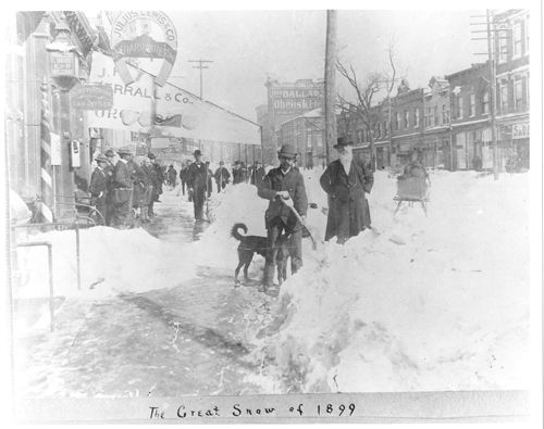
Fayetteville St. in Raleigh during the Great Blizzard of 1899 Obtained at : https://www.timetoast.com/timelines/historical-blizzards--2
www.webberweather.com
MichaelJ
Member
In GSO, the winter of 98-99 produced a whopping .6sn
Mr. Golf
Member
I guess I was wrong about Dr. Roundy. Kinda suprised he said that. Considering he knows alot about mjo stuff
Mr. Golf
Member
Larry, I know your adamant about it being a warm winter, but I read something from Dr. Roundy that the IOD has switched phases and expects a much different outcome coming up.
He probably wrong about that also. Mjo plays big factor like always. It dont get enough acceptance ?
He probably wrong about that also. Mjo plays big factor like always. It dont get enough acceptance

Honestly guys, the MJO is still a mystery. Not enough is known about its phases. I never look at MJO forecast past two weeks. Let alone this experiment model? We can’t even get hr240 and beyond accurate and this guy formed a model for two months out?
WWP are just for click bait and for viewers to tune into the 6pm news. Everyone has been burnt. When will Mets and hobbyists learn?
We have to go by the most proven factual data that is given and within the 240hr time frame is when we should analyze predictions.
There I said it. It had to be said.
Sent from my iPhone using Tapatalk
Thanks!ERIC WEBB'S NORTH CAROLINA WINTER STORM ARCHIVE
Fayetteville St. in Raleigh during the Great Blizzard of 1899 Obtained at : https://www.timetoast.com/timelines/historical-blizzards--2www.webberweather.com
We're starting to get closer to the beginning of "model winter." The EPS weeklies are beginning to approach that time, and I plotted all the airports with at least one member with snowfall. NC went up 2 from the previous run. SC and GA still have 0. This is also the first run where the Weatherbell algorithm puts non-zero totals in NC.


First CFSv2 member (two) that show snow in the SE.

Thank you all please follow me for the Latest I will have Information this winter on what looks like an exciting icy winter with snow in the west but mostly ice everywhere
FThank you all please follow me for the Latest I will have Information this winter on what looks like an exciting icy winter with snow in the west but mostly ice everywhere
B
Brick Tamland
Guest
It doesn't really matter anymore what kind of pattern we have. El Nino, La Nina, AO, NAO, on and on. We have had patterns that are supposed to produce good snow here end up producing zilch, and we've had good snow when the pattern was supposedly bad for it. I think what we used to count on for producing around here just doesn't work like it used to. We can't rely on it one way or another in winter.
cd2play
Member
I'll give him a D- out of the goodness of my shart.
")
B
Brick Tamland
Guest
Why y'all mad for me keeping it real?
Why y'all mad for me keeping it real?
Well, I mean we all have seen Anchorman. You don’t have the best accuracy when it comes to weather. Remember, you killed a guy with a trident.
Early start to winter!


Griteater over on 33andRain made some good points on the state of next winter. Basically saying that the +QBO favors more ridging over Alaska.


tennessee storm
Member
back in the good ole days when we actually had winters...
That was Dec '89, just bone dry cold here, then pattern reversed to mega warm Jan-Feb...back in the good ole days when we actually had winters...
I remember my dad running around going bat poop crazy because we had a dusting of snow on Christmas morning. It was very cold.That was Dec '89, just bone dry cold here, then pattern reversed to mega warm Jan-Feb...
tennessee storm
Member
yeah I remember that winter really well... got down below zero here, like you said mostly dry, but we did manage a decent clipper system here in west Tennessee for bout 3 inches of snowThat was Dec '89, just bone dry cold here, then pattern reversed to mega warm Jan-Feb...
Yeah, that's true, we did get .3 inches on Christmas...I remember my dad running around going bat poop crazy because we had a dusting of snow on Christmas morning. It was very cold.
D
Deleted member 1449
Guest
1989? I lived it on the OBX.Winter was done after that.
Brent
Member
Last time Dallas went below zero...
Dry as a bone though
Man we haven't even had single digits since 1996 what has happened to winter
This doesn't constitute for the start of the archive thread, but this is the furthest south in latitude that I've seen snow get to.

Look at that Wake Co. cutoff lol. Def legitThis doesn't constitute for the start of the archive thread, but this is the furthest south in latitude that I've seen snow get to.
View attachment 48557
Iceagewhereartthou
Member
CAE out of luck! ?Look at that Wake Co. cutoff lol. Def legit
This is the first time I’ve seen the LR new GEFS be available on Weatherbell. The mean is making its way into the mountains through October! I believe it gets implemented next Wednesday.

This is the first time I’ve seen the LR new GEFS be available on Weatherbell. The mean is making its way into the mountains through October! I believe it gets implemented next Wednesday.
View attachment 48635
The mean is just being mean by trying to fool us by sneaking in a “possible” taste of the good stuff. Not again King!! As former President George W. Bush said, “"There's an old saying in Tennessee, I know it's in Texas, probably in Tennessee that says, 'Fool me once, shame on ... shame on you. Fool me... You can't get fooled again!'"
Don't worry, I won't get fooled, especially by a mean 860hrs out lol. I'm just posting here because we haven't met our criteria for the archive thread. Although watch out in case the regular (384hr) GEFS gives central NC some snow.The mean is just being mean by trying to fool us by sneaking in a “possible” taste of the good stuff. Not again King!! As former President George W. Bush said, “"There's an old saying in Tennessee, I know it's in Texas, probably in Tennessee that says, 'Fool me once, shame on ... shame on you. Fool me... You can't get fooled again!'"
Don't worry, I won't get fooled, especially by a mean 860hrs out lol. I'm just posting here because we haven't met our criteria for the archive thread. Although watch out in case the regular (384hr) GEFS gives central NC some snow.
What’s the criteria?
1. if an ensemble model <384hrs (Most likely the GEFS) to have at least one member with snow outside of the mountains or the foothills eastward.What’s the criteria?
2. We get an operational run to show something in the SE, including the mountains.
Last edited:
1. if an ensemble member 2. We get an operational run to show something in the SE, including the mountains.
Thank you.
Psalm 148:8
Member
- Joined
- Dec 25, 2016
- Messages
- 345
- Reaction score
- 792
Ok... so crazy wildfires, a gazillion tropical systems... and it’s mid September and finally feeling like fall!!! Have we hit the reset button to bring us some snow???? Let’s hope so!!!
Give us another White Christmas this year Mother Nature and I can forgive all of the grievances that is the year 2020. lolOk... so crazy wildfires, a gazillion tropical systems... and it’s mid September and finally feeling like fall!!! Have we hit the reset button to bring us some snow???? Let’s hope so!!!
Fountainguy97
Member
I always enjoy using the tidbits SST analysis as an analog set. Here is the Analysis. It is a month long analysis of the current SST. Not my analogs, These are the years that are as close to this years SST's as possible. No other variables are taken into account.
.png")
All of these years are pretty strong analogs for the current SST pattern across the globe with an east based La Nina.
17-18 proved we can rock and roll in an East based La Nina and a lot of these analogs would make a lot of us happy.
Temps:


And I pulled out the snowfall maps for these years as well. Snowfall is much harder to predict due to the lack of events across a lot of our areas. Looks like feast or famine.


The common theme in all of my light research into this winter and East Based La Nina's in general seems to point toward January being the best shot for cold and snow. It seems that East based Nina's are more kind to us as a whole.
All of these years are pretty strong analogs for the current SST pattern across the globe with an east based La Nina.
17-18 proved we can rock and roll in an East based La Nina and a lot of these analogs would make a lot of us happy.
Temps:
And I pulled out the snowfall maps for these years as well. Snowfall is much harder to predict due to the lack of events across a lot of our areas. Looks like feast or famine.
The common theme in all of my light research into this winter and East Based La Nina's in general seems to point toward January being the best shot for cold and snow. It seems that East based Nina's are more kind to us as a whole.
Last edited:
^great post, I'm rolling with that....