• Hello, please take a minute to check out our awesome content, contributed by the wonderful members of our community. We hope you'll add your own thoughts and opinions by making a free account!

Tropical Major Hurricane Laura

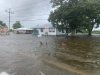
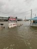
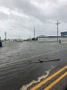
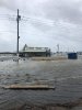
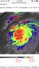
I’m pretty sure TWC will be moving farther inland after the updated forecast. The storm chasers better do the same with this monster unless they want to be stranded for a week or more.

Josh mergerman or whatever his name is will likely go after this surge. That guys crazy enough to do that


Sent from my iPhone using Tapatalk
 
Outflow looks great on all sides. But we're not seeing the whites and pinks, in terms of cloud tops encircling the eye, as much as we were earlier. Not sure if that indicates anything right now, but it appears the uplift is not as violent, currently.

Edit: And it looks to be currently on a due west heading. I'm sure that's temporary. But it's a significant little jog, nonetheless.
About an hour ago this tweet was on it too
 
Josh mergerman or whatever his name is will likely go after this surge. That guys crazy enough to do that


Sent from my iPhone using Tapatalk
I saw where he said he was studying for high points. It's going to be a hard place to find around there.
 
My god.. 30 miles inland seems insane.. is this normal or partly due to the speed at which Laura is traveling?

I have personally witnessed what a 20’ storm surge can do when I was with FEMA in NY after Sandy. If you have evac orders, do it. If not, leave your info with someone who can get it to authorities after the storm passes in case you don’t survive.
 
d2f9b5402bcc5e502c2f8c724c3e1f4b.png


Those are some pretty big swells. A lot have went off line. Even oil rigs.


Sent from my iPhone using Tapatalk
 
About an hour ago this tweet was on it too


Crankyweatherguy should NEVER be used for anything hurricane related. He is absolutely awful. He is calling this a cat 2 and saying it is weakening while pressure is falling and the storm is continuing to improve outflow, symmetry, structure, etc. He said Michael wasn't even a hurricane at one point and said it probably was a high end 1 or low end 2 at landfall. He's an absolute joke when it comes to hurricanes... just saying.

Regarding the warming cloud tops, this is quite typical in the process of a strengthening major hurricane and during the daytime as well when the cloud tops warm slightly. This storm is still strengthening quite rapidly as evidenced by the clearing eye and continued pressure falls.
 
Terrified would be the word Iwould use.....
Yeah. From a meteorology hobby/professional perspective, when we throw around words like beauty for storms it is almost always terrifying at the same time. An ugly looking storm is a relief for those in its path. Praying for those in Laura's path today.
 
Crankyweatherguy should NEVER be used for anything hurricane related. He is absolutely awful. He is calling this a cat 2 and saying it is weakening while pressure is falling and the storm is continuing to improve outflow, symmetry, structure, etc. He said Michael wasn't even a hurricane at one point and said it probably was a high end 1 or low end 2 at landfall. He's an absolute joke when it comes to hurricanes... just saying.

Regarding the warming cloud tops, this is quite typical in the process of a strengthening major hurricane and during the daytime as well when the cloud tops warm slightly. This storm is still strengthening quite rapidly as evidenced by the clearing eye and continued pressure falls.
Speaking of cloudtops look at them now. Colder tops bursting around the center now. You also don't need to see pinks for it to be a strong hurricane. So long as its constantly firing and outflow gets better and the eye rounds and shrinks some it'll intensify more.
 
Looks like the first tornado warned cell associated with the far outer bands of Laura. Tiny little cell.View attachment 47372
Yes, that's going to be passing just north of my location. I'm at the lower edge of the western side of the that box. I wouldn't be surprised to get some brief severe wx throughout today and tonight from the bands of rain.
 
Yes, that's going to be passing just north of my location. I'm at the lower edge of the western side of the that box. I wouldn't be surprised to get some brief severe wx throughout today and tonight from the bands of rain.
Being on the eastern side of the storm you will definitely have to watch out for any areas of rotation that develop.
 
What's an easy way to upload photos on this site? I haven't really done obs and pictures on this site for a real storm threat, so hopefully a more experienced member can direct me.
 
What's crazy is that the NAM and HWRF model runs from a couple days ago were shrugged off as model hype. But the current visible and IR satellite presentation looks very similar to what these models have been showing. I still don't think Laura gets below 910 or so, but that's still pretty strong.
 
I have personally witnessed what a 20’ storm surge can do when I was with FEMA in NY after Sandy. If you have evac orders, do it. If not, leave your info with someone who can get it to authorities after the storm passes in case you don’t survive.
I have a friend from New Orleans whose family intended to ride out Katrina, but changed their minds when a police officer insisted that my friend's mom write her social security # on her arm in sharpie while he watched when she was stopped at a road block headed back into the city the day before it hit, after doing an errand in Baton Rouge.
 
Is there a reason the 12z models are initializing with pressure at 971mb?

1598460410166.png

Hour 6 still has higher pressure than what it is now

1598460442663.png
 
From Firsthand Weather facebook.....

"It's already beginning. Take note that these photos were taken in Golden Meadow and Leeville, Louisiana, well to the east of where Laura will actually make landfall. Also, this is already happening, even though Laura won't make landfall until late tonight. Sadly, what's shown in these photos pales in comparison to what's about to happen in southeast Texas and southwestern Louisiana. Photos shared by the Lafourche Parish Sheriff’s Office -Matthew"
 

Attachments

  • FB_IMG_1598460394683.jpg
    FB_IMG_1598460394683.jpg
    358.5 KB · Views: 73
  • FB_IMG_1598460401277.jpg
    FB_IMG_1598460401277.jpg
    280.8 KB · Views: 74
  • FB_IMG_1598460405342.jpg
    FB_IMG_1598460405342.jpg
    286.7 KB · Views: 70
  • FB_IMG_1598460409994.jpg
    FB_IMG_1598460409994.jpg
    278 KB · Views: 66
What's crazy is that the NAM and HWRF model runs from a couple days ago were shrugged off as model hype. But the current visible and IR satellite presentation looks very similar to what these models have been showing. I still don't think Laura gets below 910 or so, but that's still pretty strong.
Happens every time.....I tend to view them with a 15 to 20 point margin. If they are bombing still after I add 15 to 20 points, I go with it.
 
First time I’ve had a chance to look at IR since morning and shear may be just close enough to take a bite out of Laura before landfall. May not weaken it, but may be enough to stop strengthening. Have to wait and see.
 

Attachments

  • 7D7A034F-5FEE-4EF7-88C4-FF423AB38964.jpeg
    7D7A034F-5FEE-4EF7-88C4-FF423AB38964.jpeg
    845.8 KB · Views: 45
Last edited:
Back
Top